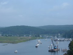
Old Lyme Marina-FLUKE in middle
As I write this latest update, the fourth installment of the 2006 Journey north, on August 13, 2006, I am sitting in the pilothouse on FLUKE at the Old Lyme Marina in Old Lyme, CT using my travel journal to organize my thoughts. We have been here since August 1, and the time has flown by. Note: it is a gorgeous day (clear, high 70's), with hundreds of boats passing by on the Connecticut River, so it is difficult to focus on the task at hand. We regret the absence of interesting photos from our travels in the Chesapeake and Delaware Bays, but there were so many days of light fog which wasn't conducive to getting any nice outdoor shots. Since then we have so many pretty shots it will be difficult to choose which ones to post.Internet access, as a whole, has been more difficult than we originally anticipated. We have only been to land a small percentage of the time, and most of those times we have had a full agenda of tasks to tend to. Then too, we have faced time limitations on computer use at some locations. Even though I can create the text for the blog at my leisure while we are underway, posting to the blog for on-line viewing can be time-consuming. The photos have to be uploaded and then inserted into the text at appropriate spots, all on-line. We don't want to just use the small format photos, so inserting for the large format use is what takes the most time. Answering personal emails is very doable, as we can just post with a regular text answer. So, keep those questions and comments coming, and we'll get back to you when we can get on-line. Sign up with the blog update feature by entering your email address in the box on the right hand side of the blog page to get notification when a new installment is posted rather than counting on getting an individual notification from us.
Now, going back in time:
MAY WE USE YOUR CAPE?
We were heading into the Cape May Canal on July 28 at the same time of the day that the local fishing boats, tour boats, and ferries were heading to their ports, so there was a lot of congestion, complicated by low tide in an area with relatively low water anyway. Fat FLUKE needs to stay in the middle where the water was the deepest, so there was some tight squeezing going on with the local boats. Our destination marina was in a dredged area that needs continual dredging, so we had the low water alarm buzzing just trying to get to our none-too-large slip at the marina. We had elected to stay in a marina because it was a Friday night, in a resort area with a lot of potential for weekend boaters, and we didn't feel quite clear on where we could find a place to safely anchor anyway. It was a good decision, as shortly after we were in our slip a thunderstorm squall line passed closely by, bringing some high winds and rain. Being tied in to the pilings felt good. Ursa jumped off the boat and bolted at full speed down the dock to a destination she didn't even have in mind-she was just going. Fortunately she ran into a dead end and was able to be trapped. Sitting and staying is actually one of her two dozen or so tricks, but when her wild streak gets turned on, there is no switch to turn it off. This is a common problem with Schipperkes according to other owners we have talked with. Laundry (6 loads) and posting to the blog were the main priorities. I figured no one would be doing laundry at the marina laundry facility on a Friday night, but I still had to wait! I had the laundry going on the boat too, but with so much to get done, I wanted to use the shore machines too. The marina boasts of having wireless internet service, but it is a very large facility, and we were informed that we may not be able to pick up a connection at the dock we were at, which proved to be true. We had to sit on a picnic table under a street light to make the chapter 3 postings, with the connection fading in and out-very frustrating since we wanted to get up at 0500 to make the long run to Sandy Hook, NJ on Saturday.
WE WERE HOOKED!
We enjoyed settled seas for our 15 hour run to Sandy Hook, but it was quite hot and we were attacked by thousands of house flies, forcing us to put up the screens and be even hotter. As we got closer to Sandy Hook we could see large freighters and commercial ships laying up at anchor, waiting their turn to go into New York Harbor, our intended destination the next day.We had decided to anchor off the Coast Guard Station: guide said good holding in settled weather. Plus, it looked like a large area and had good navigational aides which we needed with our 9:00 p.m. arrival. We were so tired, and just wanted to get the anchor set and get a good night's sleep so we could feel alert the next day. The anchor held tight on our first try, and we shut everything down and went to sleep. Sometime in the wee hours of the morning a tremendous wake hit us and practically knocked us out of bed. Despite rising early, we were surprised to see many boats already out on the water, at anchor fishing in the bay or headed out the channel to the ocean. Initially I thought there must be some kind of event taking place since they were pouring into the bay by the hundreds. Turned out to be a typical NJ/NY nice weather weekend boating day for those locals.We wanted to time our trip through New York Harbor to travel going with the current to make steering easier and more predictable, so we were anxious to get the anchor up and head up the East River. When we went to pull up the anchor we felt more resistance than usual, but kept on hauling until we saw that the anchor was hooked to a large, underwater cable that was tightly pulling downward against our upward efforts on that morning of July 29. Early on in the 2006 Voyage North, we had added a trip line and float to our anchor: to mark our anchor so others could see its position and to have an alternate way of being able to pull the anchor loose in the event it hooked on something laying on the bottom, most likely a log or rock. We never imagined we would need it to release a cable, but we were so glad to have it. Grabbing the trip line and cleating it off on the bow, enabled the anchor chain to have enough slack in it to where the cable could be pushed off the anchor. I'm not sure how we would have gotten rid of the cable without the trip line.
NEW YORK, NEW YORK: THE THRILL OF IT ALL
Despite being one of the world's busiest harbors, traveling through New York Harbor can be enjoyable and exciting with proper planning, paying attention, and observing the rules of the road (basically go slow, give way to everything bigger and faster than you). Absence of fog, rain, or wind helps too.
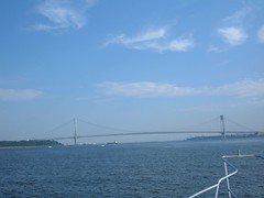
Verrazano Narrows Bridge
We crossed under the Verrazano Narrows Bridge at around 9:30 a.m. From the water, VNB looks very impressive, spanning the mile wide opening between Staten Island and Brooklyn.
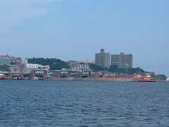
Staten Island Ferry
We passed by the quarantine area, where many commercial ships were lying in wait, mostly tended by tugs, for clearance to their docks. We were on alert for the giant freighters with limited maneuverability and slow stopping ability. There was much other water activity: ferries, harbor cruisers, water taxis, and pleasure craft. It was difficult to be able to enjoy the sights of the New York skyline, waterfront, even seeing down the streets while worrying about our own navigational situation.
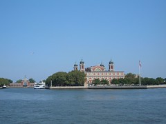
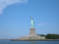
Beautiful Ellis Island
MS Freedom
We intended to use the 14 mile East River to gain passage into Long Island Sound. The East River is only one of two rivers in the world with two mouths and no source. It is well marked, and there are lots of sights to see traveling through Manhattan, Brooklyn, and Queens, going under eight high level bridges, including the most famous, Brooklyn Bridge.
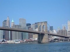
Brooklyn Bridge
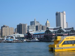
NYC Waterfront Transportation
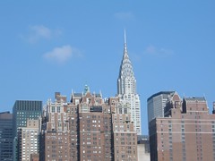
Chrysler Building
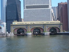
Ornate Ferry Terminal
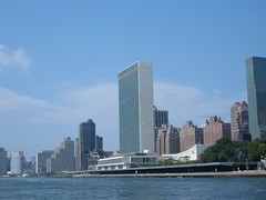
United Nations Building
We passed safely through Hell Gate, the most dangerous area of the East River. Currents can run as much as 5 knots, with lots of unpredictable eddies, whirlpools, and crosscurrents caused by water depths ranging from 34 to 107 feet in a few hundred yards. Maximum strength currents can produce 2' high waves, so timing the passage is critical for boating safety. Holding the helm wheel steady even under our good passage conditions was challenging. Shortly after that we passed Rikers Island (where bad boaters are sent to prison!) and the runway to LaGuardia airport (certainly looks different from ground level).
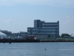
Place for Bad Boaters-Rikers Prison
A couple of gallons of diesel later, we entered into beautiful Long Island Sound, same water as the East River, but a 100% different boating vista. Catching our breath, we all agreed it was an exciting passage that would be enjoyed again on other trips, and even better if someone else was piloting the boat, so we could all take more time to see everything.
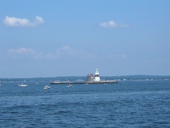
Execution Rocks Light - Long Island Sound
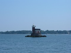
Stepping Stones Light - Long Island Sound
OYSTERS AND COLD SPRINGS
Checking our guide book, we decided that we would head into Oyster Bay, located on the south side of Long Island Sound. Since leaving the East River at an early time we figured it was still early enough in the day to be able to find a spot to anchor, despite being a beautiful Sunday. When we motored into the Bay off the Sound we were surprised to see all the boats already in the Bay. The inner harbor was packed tightly-we didn't even think of going in there, but even the outer harbor was crowded, with what mostly looked like day boaters. We found a more isolated spot on the outskirts of all the “action” and only dropped 100' of chain, but the guide book said it had good holding. Right. We couldn't get the anchor to set, but figured that later in the day, most people would leave and we could try to reset the anchor. So, throughout the afternoon, boats came and went. Several boats dropped anchors around us, disregarding our large, obvious float marking the anchor, and put out so little line with their anchors that if the wind had picked up, FLUKE would have passed their anchors and engulfed them like a whale eats krill. Finally people starting leaving, but 6:00 p.m. was approaching and we needed to get hooked properly. We tried again and failed, so we decided to try the holding around the corner in Cold Spring Harbor. Both OB and CSH are in beautiful settings with hills (180'), wooded, sparsely populated (because there are large estate homes that have enormous pieces of property) set around long-fingered inlets that come off Long Island Sound. CSH was so named in 1653 because the settlers found icy, freshwater springs in the harbor (Eddie went in the water to check out the bottom of FLUKE and said he agreed with the early settlers because he could feel pockets of frigid water swirling around him at times). In the 1800's CSH was one of Long Island's leading whaling ports and today sports a whaling museum set right amongst period homes, now converted to gift shops. We were able to find good holding in a nonpopulated area of water. Because we were still tired from the run to Sandy Hook and wanted to do some boat chores, we ended up spending July 30 and 31 peacefully hooked in the serene setting.
HOME SWEET HOME
Finally on August 1, 2006, we reached another intermediate destination of the 2006 Voyage North: Old Lyme, CT. This was the birthplace of one person near and dear to too few: Eddie. His brother and sister, have resettled nearby, and Carol's brother (who has graciously loaned us a vehicle) lives in neighboring Niantic. Plus, we have friends living in close proximity. It has been great seeing everyone, but best of all, it just feels good not to be on the move and wondering where we will be able to safely stop next. Old Lyme is mainly a residential community (approx. 8000 people), founded in the 1600s. It fronts Long Island Sound for about 5 miles and extends 12 miles north up the CT River. Old downtown is typical of many of the old New England towns, with picturesque old homes that have become too expensive to keep up, but are wonderful to look at. We have been staying in Old Lyme Marina, located just off the Connecticut River, on the north side of the I-95 bridge. OLM is not normally used by transient cruisers like ourselves, catering mostly to locals and weekenders. The facility provides repair services of various sorts for smaller boats and is a family owned business. We love it because of the low-key atmosphere and ideal location for things we like to do. Of course, we have trade-offs, like no internet service, but the library is not far away and we can do what we need there. The setting is what is really ideal. We get to watch all the boating traffic on the CT River. There are so many vintage vessels in this part of the country, and they are our favorites. Boating history abounds along the CT river, affording the opportunity for day cruises to interesting harbors, like Essex and Deep River. Hundreds of boats of all sizes and types pass by on the weekends. We are protected from wakes from Calves Island, visible in the photo. The area is tidal, so we see dramatic changes along the shoreline a couple of times a day. Various wading birds, shoreline birds, geese, and a swan family come to feed among large mud flats. We have watched fledging ospreys leave the nest and capture their own first meals instead of counting on Mom for a handout. With the cooler weather, turtles pull themselves up on the mud shore to heat up in the sun.Even the marsh grasses and plants have been beautiful to see. Purple loose strife and rose swamp mallows provide striking contrasts of purples and pinks to the brilliant greens of the grasses. Gentle breezes off the river make the colors dance about. The sounds of the water lapping the edges and wind going through the reeds are so peaceful to the senses.
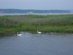
Our Marsh Friends
We have visited Gillette's Castle, built by William Gillette, actor who created the stage character of Sherlock Holmes. The home was designed by him, with a creative and artsy flair, which you would expect from an actor. The home has 47 doors, no two alike. The wood working and stone work are fascinating.
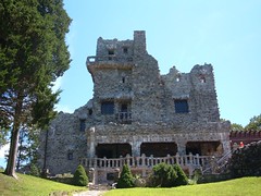
Gillette Castle
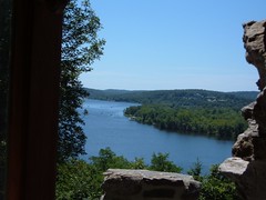
View From Window of Gillette Castle
Not far away is Devils Hopyard State Park. This picturesque park was the site of a grist mill in the 1600s, easily imagined by the natural falling waters.
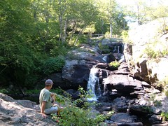
Devil's Hopyard
While we are comfortable here and have been spoiled by gorgeous weather, conveniences, and comforts of familiarity it is time to move on towards Maine, our final destination for the great voyage north and our intended haven of safety for the remainder of the 2006 Atlantic Hurricane season. We hope to be back here at OLM and spend more time as we head south in the Fall.


