APRIL 22-APRIL 30, 2007
Yes, it is worth the effort to get here.
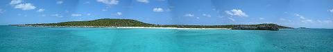
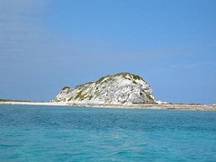
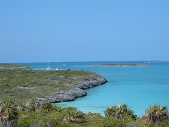
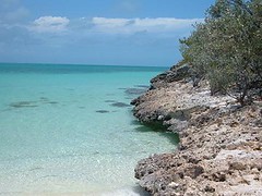
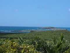
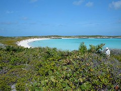
Flamingo Cay Anchorage PanoramaFlamingo Cay lies at a latitude of 22.53' N/75.52'W. We are actually further south than Havana, Cuba! We are too far south now to pick up satellite TV, so we will finally get some reading done and catch up on watching some DVDs. The uninhabited island is about 1 ½ miles long and ¼ mile wide at the widest point with the highest point being a peak of 90', pretty high for this part of the world. The western shore, facing the calmer, shallow Banks, has 4 pretty little coves with small sandy beaches.
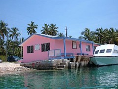
 FLUKE at anchor
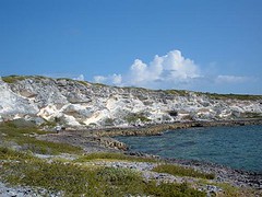
The eastern shore endures a violent existence open to the ocean; the shoreline is all sharp, gigantic limestone boulders, littered with flotsam and jetsam from both Mother Nature and us, indestructible plastic and rubber obsessed, humans. You might as well just drown yourself rather than to try to land on the shore. We can see the windward side of the island to the south of us, and waves are crashing the shore with water spraying 20-30' high when the wind is peaking. Even from our distance it is a formidable sight.
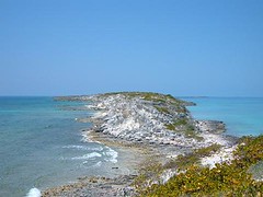
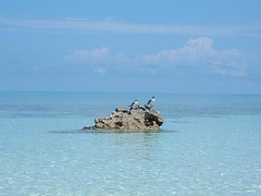
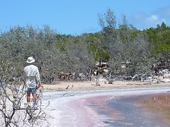
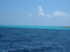
 View to the south
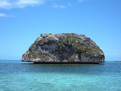 Rock off southern end
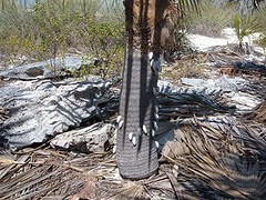
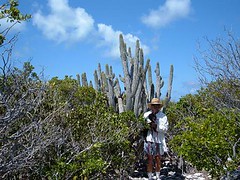
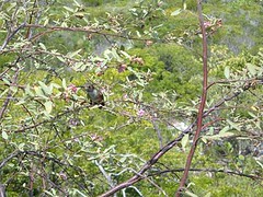
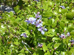
Vegetation is now nice and green, but everything is more bonsai-like because of sparse rain, tiny amount of soil, and constant wind. Some of the "trees" look ancient; they are gnarled, bent over, and their roots are anchored tightly into the cracks and small holes through the rocky substrate. The plants have thick, waxy coatings to protect from the salt air and drying heat. There are a few species of plants in bloom, and their colors are vivid in the brush with butterflies making frequent forays for nectar.
 Island hues
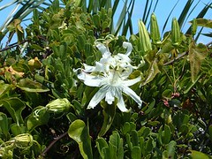 Wild passion flower
Like many of the islands, this one has the resident number of cactus plants and poisonwood which makes it essential to watch where we walk.
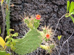 Blooming cactus
Several species of birds (no flamingos now!) make the island their home, and their songs are ever present in the air. I have taken sugar ashore for the bananaquits, birds we've had land on our boat and take sugar out of our hands while in the Exumas. Apparently the ones here haven't turned into beggars yet. There is a resident hawk who we have watched chase other birds for an evening meal right out of the sky. The lower parts of the island have a couple of inland ponds and even a blue hole.
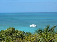
We have good holding in a sandy bottom, close in to one of the beaches; we call it our beach, since no one else is around us. We can only stay here if the winds continue to blow out of the N, NE, SE, and a little S, for if we get a westerly wind we will be blown upon the shore. We have 200' of chain on the bottom, and our anchor sits within 200' of the shore. Eddie and I actually snorkeled in the water to find the right spot to drop the anchor as many places are just a thin layer of sand over a hard bottom and the anchor won't hold us tight in areas like that. We are always watching the weather. We have been getting mostly reliable weather information from our NAVTEX system, which is being broadcast by short-wave radio out of Miami. Because the island is small, with ocean cuts on either end, our anchorage is prone to the dreaded ocean surge which sometimes comes from the north or other times, the south. We just roll back and forth and hold on to everything. The potatoes were rolling in the microwave, so I had to judge the roll to get them properly positioned. Yes, it is still worth that inconvenience too.
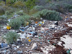
This is considered a remote area by cruising standards, so it is with much sadness that I will speak of how much garbage abounds, on land and in the sea. There are huge bags of garbage left up in the brush along the shore. Some people have had the sense to burn it, but not everyone is willing to make that extra effort. The sea floor is littered with bottles, cans, personal items, and cast off boat parts. This is a popular stopping area for Bahamian fisherman, as evidenced by the piles of hundreds of conch shells that litter the sea floor in areas where the mother ship anchors for the night or day to clean conch and rest. We would like to hope that the natives are leaving the trash rather than our fellow cruisers.
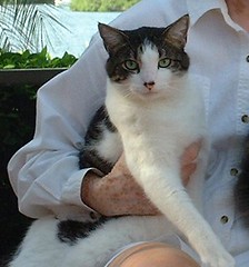
On a more positive note, the waters surrounding Flamingo Cay abound with numerous isolated coral heads, many of which are close enough to FLUKE so that we can swim to them from the boat. They are in water ranging from 8-20', so it is easy to see the habitat and even swim down and look under ledges and into holes. So many different species of sea creatures find shelter in these isolated coral heads since they provide good shelter from the open water predators. While, the water is still pretty cool by my standards, I have a new wetsuit that is working great, and I can stay in the water as long as I want without feeling uncomfortably cold. Plus, I can leave the boat on my own and don't have to listen to my crewmates tell me to hurry up because they aren't taking the time to see the undersea wonders that I seek. Oh, Jacqueline Cousteau is my nickname, in case you hadn't heard!
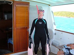 Jacqueline Cousteau
Eddie and I have continued to try our luck fishing from the dinghy over the isolated coral heads using the same technique that we tried over in Andros. We have been more challenged here though.
We still need to catch our bait by trying to use tiny hooks so that we will only get tiny fish. However on one coral head we ran into some large queen triggerfish (they all have giant buckteeth) who just kept getting the bait before the little guys could latch onto it. We brought up a couple of them, but didn't want to keep them for food and didn't want to cut them up for bait because they were just too beautiful so we threw them back. One even bent our hook with those big teeth! There are 3 large (3') remora that are hanging under FLUKE's big belly. They are the sleek fish with the funny grooves on the top of their heads that you always see stuck on the undersides of sharks. They eat whatever scraps we throw overboard and would be easy to catch for bait, but now they seem like pets, and we're not desperate enough to have to do them in. We are NOT ruthless hunters!
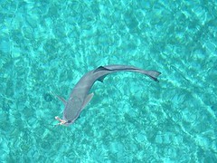
We are fishing in about 20' of water, and all the fish look smaller than they really are as we peer through the looking bucket. I had a BIG surprise when I was looking down at the bait when it was eclipsed by only the head of a nurse shark. Nurse sharks breed in nearby waters in May and June. That beast was so big I had to move the bucket back and forth to see the whole length, and Eddie thought it was almost as long as the dinghy. We haven't ever seen one larger. Yet, that shark was so determined to get that little snippet of bait-it would be like one of us eating a single M & M. I kept yelling at Eddie to get the line out of the water since we would definitely loose that battle if the shark got a hold (we've already had that happen, and it's just frustrating to lose everything).
When Eddie would bring up the bait, the shark would go right to the bottom where the bait had been and scoot its snout into the sand in a circular motion just trying to find the little piece. This behavior was so persistent that we had to move to another coral head. In the edible species department we did manage to get a nice red snapper which was filleted and put in a tequila-lime marinade, covered with bread crumbs and baked until flaky. Real yummy.
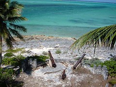
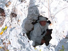
The Cave of Enlightenment
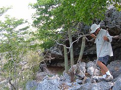
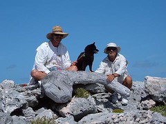
I've told you before that a big part of our cruising adventures involves land exploration. Flamingo Cay offers a lot to see if you put on a good pair of durable walking shoes, lots of sunscreen and a hat, and watch where you step. We hike right after breakfast before the heat of the day becomes too overbearing for all of us. Ursa scampers along like a mountain goat, but we don't want to let her get overheated. Walking is difficult: the rocky limestone ground is sharp with lots of loose rocks. Some places feel like you are walking on the points of dull knives. You can't afford to slip or your skin will be sliced open, even through your clothes. There are a lot of cacti in some areas. Eddie brushed up against some with his leg and bent over to try to pull out the barbed spines, only to get a bunch more stuck in his rear end!
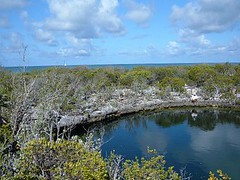
We have hiked to the highest peak on the island where a navigational beacon is located. It works by a solar panel to generate power for a flashing light so sailors can use it as a good reference point from the sea or the Banks. The view is so beautiful: down into the leeward cove where FLUKE rests, out into the roiling ocean, over the green of the landscape below dotted with colorful salt ponds, and right down the rocky chain of islands to the south.
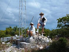 At the peak
The island is best known for a large sea cave that you can actually drive your dinghy right up into. The cave is also accessed from the landward side through a small opening in the rocky cliff. 3 holes in the roof of the cave provide light to the darkness below and make for an interesting effect on the waters splashing within.
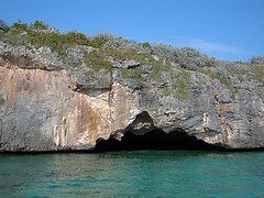 Sea cave
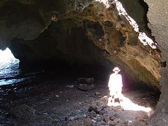 Eddie's enlightenment
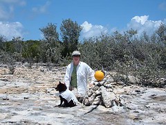
There are some ruins of an old homestead, walls made of some cement mixed with pieces of shell and rock. A big pit in the rock near the site is an old well which was the home's water source. Grave sites are nearby. You can't dig in the ground, so bodies are just laid out and piles of rocks are stacked thickly on top. The area is pocked with vacant cavities-you have to be careful not to fall down in any. One hole is big enough for one person at a time to climb down into and can hold 5 people under the ground.
 Indiana Jones
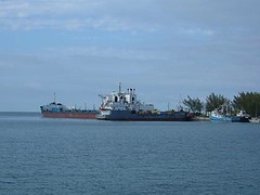
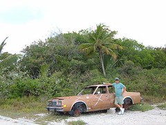
In the cove nearest to the homesite sits the wreck of the John T. Davis, an island freighter who made its last, probably unscheduled, delivery to Flamingo Cay when it was wrecked upon the shore.
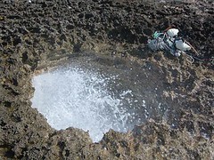
We always want to try to get to the far side of the island from that which where we are located. So, we sited the land, looked for a trail and made the effort to try to get to the cove located on the north side of the island. We walked through a lowland area that was pocked with several small irregularly shaped ponds circled with shimmering silver buttonwoods and red hued succulents. Two of the ponds contained 2" long shrimp, brilliant orange in color. There was also a blue hole, only about 3-4' in diameter, but whose bottom was not visible even in the crystal clear water.
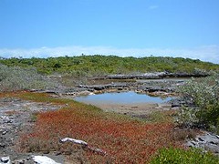 Lowland pond
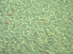 Orange shrimp in pond
There were a few cairns (piles of rocks) haphazardly marking a trail but we managed to get to our destination. We named the cove, airplane beach because of the amphibious plane wreck that sits in the cove.
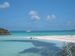
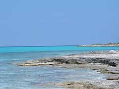
 Beach at northern anchorage
From there we hiked over some exceptionally rocky terrain with a couple of burial mounds (probably from the plane wreck) to the ocean.
 If I had a hammer
No sand here, just lots of rocks and whatever the ocean has thrown upon them. We collected a couple of dozen shoes (the number one human item, besides plastic garbage, we see in the islands). On the way back we clearly remarked the trail with the shoes, so future hikers could easily follow the way using the new “footpath”. A few days later some friends we met tried out the new marks and said they were great.
Black Hawk DownSince the Bahamian Defense Force (a kind of Navy) is mostly non-existent (they are too poor to keep up with the overhead) the U.S. government pays the Bahamian government some probably ridiculous sums of money so that we can fly drug interdiction flights along their coastline in the never-ending battle to combat drug smuggling. The little remote area of the world that we are floating in used to be an easy place to offload drug cargo from small ships or planes for transport to attractive ports. So, frequently we have seen a Black Hawk helicopter skimming just over the top of the island. We always give them a friendly wave, and they wave back.
One day, while Wayne was making lunch I heard the helicopter approaching from its northern flight path. Here is what I said: "Wayne, it's coming in lower than usual today. I think it is beginning to turn over the southern end of the island and is banking hard to the right, bringing it toward our beach. I think it's going to land!" Sure enough, the pilot slowly lowered the chopper onto the thin strip of sand, causing the sand to violently swirl upward and outward to where we wondered if it was all going to blow onto FLUKE. Fortunately the wind was in our favor and kept it away. Two men got out of the chopper, one wearing a gun strapped on his leg. They began to walk toward the cave of enlightenment. Another man got out and stood in a guard position outside of the open door to the fuselage. The two pilots remained at the controls. We waved at them, and they waved back. After a short period of time the two men who went to the cave area came back, laughing and smiling, one pulled a ski mask over his head so the sand that was still being kicked up from the rotating blades didn't cover him, and then all 3 piled back into the chopper and took off. It was the week's biggest event in this tiny speck of paradise.
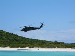 Black Hawk down
We haven't been totally alone in this little corner of the world.
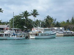
The afternoon we arrived there were 5 boats already anchored, to our surprise, although because it had been so windy, Flamingo offered better protection than some of the other islands in the chain. 4 of the boats left within a couple of days. 2 more showed up, 1 of which only stayed 2 days.
The boat that remained was Highlander, a beautiful sailboat belonging to John and Mary Ann Cowell, land home Geneva, NY. They are the same age as Wayne and I, have traveled to places we hope to visit, retired early, and love the Bahamian islands. It was fun visiting each other's boats and sharing stories about adventures.
The day before we left Veda L, a Krogen 48 (it has the same hull as FLUKE, but different superstructure) with Bob and Linda Turrentine from Stillwater, MN arrived. We enjoyed talking with them, and it is always useful to see how other boaters with a boat like yours run things.
The Bahamian fisherman have been using the western side of this island for anchoring their mother ship while the fisherman go out in their launches to get conch from either the Banks or shallow areas around the islands. Their mother ships are a varied sort of boats in the 50-60' range, some wood, some fiberglass with open deck spaces to store fishing supplies. They have generators to run their refrigeration units so that they can store their catch while they are out 7-10 days before having to head back to port to sell their catch. We hear them talking on the radio with island names such as Green Lizard or ones you wonder how they come up with, like San Diego. The launches are small skiffs about 15' long with 25HP outboards. Usually 2 fisherman go out in each skiff and have to free dive in water 15-25' deep to hand pick conch which they throw into the skiff. We have seen them cleaning the conch while underway or waiting until they get back to the mother ship. This year the Bahamian government has issued a new fishing regulation saying that cruisers are prohibited from getting any conch at all. What all the cruisers in a single season combined would catch is probably less than what one of the fishing boats takes back after a single trip. There is no question that the conch population has been seriously depleted: we see few mature adults now compared to even 5 years ago and the fisherman are having to go to farther, more remote areas to find them. However, cruisers are not the problem, but at least regulating their catch may be a start in the right direction.
We watch the Bahamians do their work while we do our work too: all is not just fun in the sun. We sat at anchor for 3 days before we launched our dinghy; it was just too windy. So, we have spent some time trying to modify our launching technique, with our safety and that of the dinghy and FLUKE in mind. Last year our winch motor failed and the boom crashed into the upper deck railing, bending the railing and scaring us to death, so that event is always on our minds.
Wayne and Eddie had to spend an entire morning working on the sewer system, which included the totally disgusting job of disassembling the pipes (heavily coated with you-know-what) to the master head to determine that the bellows had a crack in it, so the system was not getting the adequate amount of air to create a vacuum to move the waste through properly. Having a spare bellows on hand is not part of a normal inventory item, so we had to declare that toilet to be inoperable. So now we will all have to use Eddie's, and he is less than thrilled about that.
This is the second sewer problem we've had on this trip. When the guys start talking sewer issues I make it a point to say that I need to work on food preparation. That always works to get me out of having to help them with that nasty job. The position of head chef carries a lot of clout on FLUKE, and I reward them dutifully. After the bellows episode they were treated to one of their favorites, taco salad and cold beer. Oh, but I like it too!
We've had a couple of rain showers and have managed to collect about 15 gals. of rainwater from drains we hooked up to the pilothouse roof. Eddie has gotten out his camp shower and suspended it over the swim platform and delights in taking outdoor showers-it reminds him of his Cub Scout days, before they kicked him out. We also use the water to rinse the salt off our gear and the cockpit floor where we always step with our wet feet or clothes that have gotten salt water on them.