The Open Window
May 26 – May 28, 2007
Here it is, already June 2. I'm sitting in the pilothouse with the wind howling, intermittent rain tapping on the windows, and FLUKE straining at her home dock lines as the remnants of tropical storm Barry are blowing by. You didn't miss anything by not being with us for our great escape from the Bahamas.
On May 26 we felt like a weather window was beginning to open up enough for us to consider making the jump from the Exumas chain over to the big island of New Providence, which most of you would know better by the name of its principal tourist port, Nassau.
We endured a sloppy, mostly uncomfortable ride in seas of only 2-4', but directly on the starboard side which kept us pushed back and forth more than we like. After being underway for 7 hours, as we neared New Providence, we decided to try to drop anchor in Southwest Bay. The bay is located off a residential area near the airport and would give us a good head start on the westward path we would have to take the next day. Most cruisers choose to just go into Nassau harbor, but we didn't want to expend the effort or money to get into a marina and be hampered the following morning if we wanted to leave very early.
We put out 200' of chain, backed down tight on the anchor and knew that the winds would remain mostly the same and felt secure enough. The anchorage was fairly comfortable in the 15-20 knot winds until it got a bit rolly around 0400. We needed to get going early anyway and were underway by 0630.
From the VHF chatter it was apparent other cruisers were trying to decide to make a move westward too. Their boats had been restrained much too long. We wanted to get us much distance under the keel as we could to try to stage ourselves to take advantage of the tiny crack in the persistent pattern of the relentless blowing winds that looked like it might open within the next 24 -36 hours.
So, we beat ourselves in 3 – 5' seas across the deep water of Northeast Providence Channel and anchored in a sand bore area of the Banks west of Chub Cay. The shallows of the sand bores gave us some protection from water surge, but virtually none from the wind. It was so noisy in the bow area from the anchor chain, water slapping, and wind howling, I elected to sleep on the settee in the salon. I didn't worry about the anchor dragging since we were in the middle of nowhere with no one around to run into and plenty of open Banks area to move through without getting hung up on anything.
We were underway by 0615 on May 27 and headed toward Bimini with an eye to the NAVTEX and VHF to try to gauge incoming weather reports to see if we should stop at Bimini as we approached mid afternoon or just keep going and try to make the jump across the Gulf Stream. Weather info indicated we had about 12 hours of the same weather we had been enduring and within 24 hours, winds were likely to pick up more and the little weather window would be closed for 3 days or more. That meant we would be stuck in Bimini for an undetermined amount of time. Since FLUKE was doing such a fine job of dealing with our conditions, we elected to make the jump across the Stream. Poor Eddie had been seasick for 2 days, but he was going to be sick under most any choices that lay ahead anyway.
So, we passed north of Bimini not taking long to leave the last sight of land behind us, angled northwest, sometimes approaching speeds of almost 11 knots as the Gulf Stream current pushed us along. We were thankful that the winds had shifted more easterly, taking some of the northern edge off the waves and giving us a better ride in 4 – 6' seas. I felt safe knowing that FLUKE could handle the conditions even when we were hit by errant waves that heeled us way over to port. Some dark clouds and a bit of rain briefly crossed our path. We cautiously watched a waterspout form from a tiny spike out of a black cloud, growing a long tail until the force of its vortex was enough to draw up the water from the sea into its swirl of activity. Fortunately it was moving predictably to our west, well out of our path. I posed the questions "Do they form at night, and if so, how are you supposed to see them?"
Our 22 hour straight passage, although rather uncomfortable, was mostly uneventful. Wayne and I got in a big argument when the lights from the port of Palm Beach were clearly and closely in view just before midnight. I wanted to get out of the rolling ocean and go into port to anchor and rest for 5 or 6 hours and then spend the following day getting to the home dock via the calm waters of the ICW. Both guys outvoted me by saying they wanted to just keep going and get back ASAP. So, we pulled into the fuel dock in Ft. Pierce at 0400, got a couple hours sleep, took on 550 gallons of diesel fuel and made the 2 hour trip to the home dock, tired but safe and secure.
Sunday, June 03, 2007
The Exumas: Black Point, Shroud Cay
Is the Coast Clear?
The May 19 weather forecast indicated that the very unsettled, potentially dangerous, system that had been hanging over Cuba for the last week was not going to head our way after all. So, despite cloudy skies, intermittent rain, and more wind than we wanted, we decided to begin making passage northward. We were still going to be "trapped" in the Exumas by the high winds but we could gain some northward distance with a short passage in Exuma Sound and then cutting over to the protected Banks such that when we had the opportunity to make a jump across one of the seas whose waves were still too big for us to cross we would be in a better position with less distance to cover. What had appeared to originally be a leisurely cruise back to Florida, dropping anchor for some play days and easily getting to the home dock in time for the appointments we all had scheduled for the last week of May was now looking like we had "missed the boat" and had little chance of getting back in time. This type of weather in late May is not what boaters, or even natives, ever expect to see. Radio chatter comments all say that it seems like the calender has been turned back to February.
The seas in Exuma Sound were surprisingly calm so we put out the fishing lines, hooked two dolphin, but only got one in the boat. Just getting the fish to the boat is a lot of fun as they are really aerial acrobats, wildly jumping out of the water, their blue, yellow, and green colors flashing brilliantly. Just when you think they are tired, and you reel them close to the boat, they take a look, make one last violent thrash or deep dive to try to break free. Landing them is always good for a lot of yelling aboard FLUKE.
Skies looked menacing as we moved northward: we could see scattered thundershowers in the distance and heard VHF reports that waterspouts had been spotted. As we were eating our lunch of BLTCPs (bacon, lettuce, tomato, cheese, and pickle sandwiches) thunder rumbled in the distance. Ursa's ears perked up, and she ran downstairs. I could hear that she had jumped up in the bed and was clawing (we call it digging) furiously at the sheets. Through a mouthful of my sandwich I remarked that someone (presumably Wayne, since Eddie was at the helm) needed to go get her before she tore the sheets or wet the bed. Ursa's anxiety towards thundershowers has intensified in the last couple of years to where it seems like she is having a panic attack. She pants, whimpers, digs into cushions or under pillows, and is just plain terrified, usually resulting in loss of bladder control if we have not recently taken her out to use her mat. This activity sets up the blog for its next episode:
The Princess and the Pee
No, that isn't a misspelling of the title of that wonderful fairy tale about the princess and the problem she was having with a pea under her mattress causing a miserable night's sleep. That would be too simple.
The skies opened up, the rains came down (we collected 30 gallons of water in 10 minutes, could have had much more, but we filled all our buckets on the upper deck), thunder rumbled, and the Princess continued to dig.
When Wayne finished his BLTCP, he went downstairs and yelled up that Ursa had peed right in the middle of the bed. I thought he was joking, but he said he wouldn't joke about something like that. His damage control report indicated that the top and bottom sheets and the mattress pad were wet. Immediately I questioned the condition of our brand new, ultra-expensive mattress. Still dry! I closed my eyes and silently thanked that mattress salesman for talking us into looking at the demonstration for that $100, at the time, seemingly ridiculously priced, high tech, microfiber mattress pad that was guaranteed to hold back all human and animal fluids. It had already been "christened" with some cat puke, but that was of more solid substance, so its pure liquid holding capabilities were now being put to the true test, and it passed with flying colors. No warranty claim needed for this product!
OK, now the big clean up at sea would begin. With the rain subsiding, Eddie plugged up one of the deck drains to retain water. I put laundry detergent into one of the large buckets and dipped in the sheets, swishing them more violently than my washing machine sitting at home in Vero could. Then, I handed them over to Eddie who did a pre-rinse in the standing water on the plugged deck by swishing them with his feet. These are queen size sheets, so they are a bulk to handle to say the least to wash and rinse by hand or foot. After the prerinse was completed, they were put in a bucket of clean rain water. The "spin cycle" consisted of Eddie and I twisting them tightly to wring out as much water as possible. Maybe not as good as the true Whirlpool treatment, but by Bahamian standards it would have to do. We layed out the sheets on the deck chairs to dry as much as they could and then put them in the dryer when we ran the generator after we anchored.
Ursa doing it the right way
The magic mattress pad presented more of a drying problem since it was so thick. To hasten its drying, we rigged a line on the bow from the burgee pole to the bridge railing (no room in the aft deck since the dinghy was there and the pad needed a lot of free flying room) and hung the pad on it. I thought it was a great place for it since we could keep an eye on it in the event the wind started to blow it off. The guys thought it looked stupid, having it billowing on the bow while underway. I suggested they think of it as a spinnaker and quit worrying about being seen by other cruisers. Besides, who cares what the likes of a yachtsman who owns a megayacht named HOOTER PATROL, which passed through the cut where we anchored for the night, would think of our spinnaker?
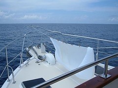
FLUKE's spinnaker
Great Guana Cay, Exumas
May 19 – May 20, 2007
We crossed over from Exuma Sound through Dotham Cut to access the harbor where we decided to anchor off the town of Black Point. We had visited here in 2000, felt comfortable in the anchorage (it is huge, with a nice, sandy bottom and good holding for the bad weather we're faced with), and liked the town which is why we stopped here again.
We enjoyed another meal of fresh fish from the sea; even Ursa and Visitor were treated to some raw tidbits during the lengthy cleaning process. Long, hot, showers were everyone's treat since we knew we had ample water to last the rest of the cruise.
An inter-island freighter arrived, a real community event. It is interesting watching the cargo get off loaded: plants, produce, lumber, engines, boxed goods, and even people. Locals show up to watch the activity even if they aren't getting anything from the boat.
A Sunday morning walk around the small town found the doors of the church wide open and the parishioners singing loudly. All the businesses, as few as there are, were closed as we expected. A friendly man, named Willie Rolle, stopped to talk to us to give us some local information and said "I'm dee one in dee guide book". Since our guide book is over 10 years old, and he is in it, it's obvious he is the town greeter of great longevity.
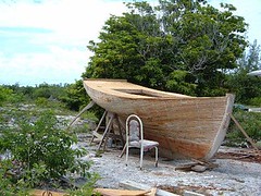
Native boat building project
Shroud Cay, Exumas
May 21, 2007 – May 25, 2007
Shroud Cay is one of our favorite islands in the Exumas. We fell in love with it when we were here in 2000 so we were looking forward to making the 35 mile trip northward from Black Point and getting reacquainted with its natural landmarks. The entire cay is unpopulated and criss crossed with mangrove-lined tidal creeks, some of which flow all the way to the ocean. It is so fun to kayak or dinghy through the creeks when the tide is right.
Shroud Cay anchorage
This cay is within the boundaries of the Exumas Land and Sea Park. All cays and waters that lie within the park are deemed "no take" zones. That means visitors can't take anything, living or dead, from the environment: no fishing of any kind, no lobstering, no shelling, no cutting vegetation on land. This policy helps visitors see the area in a less spoiled light, particularly because it protects many of the fish, lobster, and mollusk species which are being depleted throughout all the Bahamas.
There are moorings for rent for $20/night that can accommodate boats even larger than ours, so we felt safe being tied to one of them while we rode out the squalls with their high winds and sometimes heavy rains. This weather was so persistent we were unable to launch Fin the 5 nights we were here. Our satellite TV reception is back again, but the boat is swinging so quickly the receiver can't keep up with the signal. We were only about 100 yards from shore, so we could swim to the shore from FLUKE and snorkel along the lee shore and still have a great time (if the sun was shining!) despite the nasty wind.
This "neighborhood" is very popular with the megayacht crowd, and we have seen many beautiful yachts at anchor in the area west of us. They are 2 or 3 times the length and height of FLUKE and light up the sky at night. One afternoon a sea plane landed right next to us and offloaded 3 passengers who went aboard one of the yachts. Another time, a sea helicopter with pontoons for landing on the water passed eye level right in front of our bow and had to go upward to clear the cay.
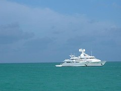
Our megayacht neighbors
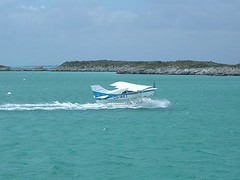
Touching down
One afternoon I look out onto the misty Banks and see an inter-island freighter headed south with numerous tall white "sticks" on its deck, unusual looking cargo. Looking through the binoculars I realize that those sticks are really many masts of boats, probably the elegant island sloops being taken to Long Island for the regatta that is coming up. No shortage of wind for their event: things really be jumpin' there, mon.
I'm saddened, knowing we will have to keep moving north, and all too soon, make the big crossovers over open oceans to the west and back to the coast of Florida. I haven't done enough snorkeling, fishing, or beach combing. The days have flown by despite our weather woes. The guys really get the message when they see me clean out the downstairs freezer and transfer the remainder of the frozen food to the galley freezer which had emptied enough to hold all the food we have left. "Hey, are we going to run out of food?" they ask. " You will be able to eat your ways back to Florida, just as you have all through the southern Bahamas. Tick tock, eat by the clock. No be worried, mon."
The May 19 weather forecast indicated that the very unsettled, potentially dangerous, system that had been hanging over Cuba for the last week was not going to head our way after all. So, despite cloudy skies, intermittent rain, and more wind than we wanted, we decided to begin making passage northward. We were still going to be "trapped" in the Exumas by the high winds but we could gain some northward distance with a short passage in Exuma Sound and then cutting over to the protected Banks such that when we had the opportunity to make a jump across one of the seas whose waves were still too big for us to cross we would be in a better position with less distance to cover. What had appeared to originally be a leisurely cruise back to Florida, dropping anchor for some play days and easily getting to the home dock in time for the appointments we all had scheduled for the last week of May was now looking like we had "missed the boat" and had little chance of getting back in time. This type of weather in late May is not what boaters, or even natives, ever expect to see. Radio chatter comments all say that it seems like the calender has been turned back to February.
The seas in Exuma Sound were surprisingly calm so we put out the fishing lines, hooked two dolphin, but only got one in the boat. Just getting the fish to the boat is a lot of fun as they are really aerial acrobats, wildly jumping out of the water, their blue, yellow, and green colors flashing brilliantly. Just when you think they are tired, and you reel them close to the boat, they take a look, make one last violent thrash or deep dive to try to break free. Landing them is always good for a lot of yelling aboard FLUKE.
Skies looked menacing as we moved northward: we could see scattered thundershowers in the distance and heard VHF reports that waterspouts had been spotted. As we were eating our lunch of BLTCPs (bacon, lettuce, tomato, cheese, and pickle sandwiches) thunder rumbled in the distance. Ursa's ears perked up, and she ran downstairs. I could hear that she had jumped up in the bed and was clawing (we call it digging) furiously at the sheets. Through a mouthful of my sandwich I remarked that someone (presumably Wayne, since Eddie was at the helm) needed to go get her before she tore the sheets or wet the bed. Ursa's anxiety towards thundershowers has intensified in the last couple of years to where it seems like she is having a panic attack. She pants, whimpers, digs into cushions or under pillows, and is just plain terrified, usually resulting in loss of bladder control if we have not recently taken her out to use her mat. This activity sets up the blog for its next episode:
The Princess and the Pee
No, that isn't a misspelling of the title of that wonderful fairy tale about the princess and the problem she was having with a pea under her mattress causing a miserable night's sleep. That would be too simple.
The skies opened up, the rains came down (we collected 30 gallons of water in 10 minutes, could have had much more, but we filled all our buckets on the upper deck), thunder rumbled, and the Princess continued to dig.
When Wayne finished his BLTCP, he went downstairs and yelled up that Ursa had peed right in the middle of the bed. I thought he was joking, but he said he wouldn't joke about something like that. His damage control report indicated that the top and bottom sheets and the mattress pad were wet. Immediately I questioned the condition of our brand new, ultra-expensive mattress. Still dry! I closed my eyes and silently thanked that mattress salesman for talking us into looking at the demonstration for that $100, at the time, seemingly ridiculously priced, high tech, microfiber mattress pad that was guaranteed to hold back all human and animal fluids. It had already been "christened" with some cat puke, but that was of more solid substance, so its pure liquid holding capabilities were now being put to the true test, and it passed with flying colors. No warranty claim needed for this product!
OK, now the big clean up at sea would begin. With the rain subsiding, Eddie plugged up one of the deck drains to retain water. I put laundry detergent into one of the large buckets and dipped in the sheets, swishing them more violently than my washing machine sitting at home in Vero could. Then, I handed them over to Eddie who did a pre-rinse in the standing water on the plugged deck by swishing them with his feet. These are queen size sheets, so they are a bulk to handle to say the least to wash and rinse by hand or foot. After the prerinse was completed, they were put in a bucket of clean rain water. The "spin cycle" consisted of Eddie and I twisting them tightly to wring out as much water as possible. Maybe not as good as the true Whirlpool treatment, but by Bahamian standards it would have to do. We layed out the sheets on the deck chairs to dry as much as they could and then put them in the dryer when we ran the generator after we anchored.
Ursa doing it the right way
The magic mattress pad presented more of a drying problem since it was so thick. To hasten its drying, we rigged a line on the bow from the burgee pole to the bridge railing (no room in the aft deck since the dinghy was there and the pad needed a lot of free flying room) and hung the pad on it. I thought it was a great place for it since we could keep an eye on it in the event the wind started to blow it off. The guys thought it looked stupid, having it billowing on the bow while underway. I suggested they think of it as a spinnaker and quit worrying about being seen by other cruisers. Besides, who cares what the likes of a yachtsman who owns a megayacht named HOOTER PATROL, which passed through the cut where we anchored for the night, would think of our spinnaker?
FLUKE's spinnaker
Great Guana Cay, Exumas
May 19 – May 20, 2007
We crossed over from Exuma Sound through Dotham Cut to access the harbor where we decided to anchor off the town of Black Point. We had visited here in 2000, felt comfortable in the anchorage (it is huge, with a nice, sandy bottom and good holding for the bad weather we're faced with), and liked the town which is why we stopped here again.
We enjoyed another meal of fresh fish from the sea; even Ursa and Visitor were treated to some raw tidbits during the lengthy cleaning process. Long, hot, showers were everyone's treat since we knew we had ample water to last the rest of the cruise.
An inter-island freighter arrived, a real community event. It is interesting watching the cargo get off loaded: plants, produce, lumber, engines, boxed goods, and even people. Locals show up to watch the activity even if they aren't getting anything from the boat.
A Sunday morning walk around the small town found the doors of the church wide open and the parishioners singing loudly. All the businesses, as few as there are, were closed as we expected. A friendly man, named Willie Rolle, stopped to talk to us to give us some local information and said "I'm dee one in dee guide book". Since our guide book is over 10 years old, and he is in it, it's obvious he is the town greeter of great longevity.
Native boat building project
Shroud Cay, Exumas
May 21, 2007 – May 25, 2007
Shroud Cay is one of our favorite islands in the Exumas. We fell in love with it when we were here in 2000 so we were looking forward to making the 35 mile trip northward from Black Point and getting reacquainted with its natural landmarks. The entire cay is unpopulated and criss crossed with mangrove-lined tidal creeks, some of which flow all the way to the ocean. It is so fun to kayak or dinghy through the creeks when the tide is right.
Shroud Cay anchorage
This cay is within the boundaries of the Exumas Land and Sea Park. All cays and waters that lie within the park are deemed "no take" zones. That means visitors can't take anything, living or dead, from the environment: no fishing of any kind, no lobstering, no shelling, no cutting vegetation on land. This policy helps visitors see the area in a less spoiled light, particularly because it protects many of the fish, lobster, and mollusk species which are being depleted throughout all the Bahamas.
There are moorings for rent for $20/night that can accommodate boats even larger than ours, so we felt safe being tied to one of them while we rode out the squalls with their high winds and sometimes heavy rains. This weather was so persistent we were unable to launch Fin the 5 nights we were here. Our satellite TV reception is back again, but the boat is swinging so quickly the receiver can't keep up with the signal. We were only about 100 yards from shore, so we could swim to the shore from FLUKE and snorkel along the lee shore and still have a great time (if the sun was shining!) despite the nasty wind.
This "neighborhood" is very popular with the megayacht crowd, and we have seen many beautiful yachts at anchor in the area west of us. They are 2 or 3 times the length and height of FLUKE and light up the sky at night. One afternoon a sea plane landed right next to us and offloaded 3 passengers who went aboard one of the yachts. Another time, a sea helicopter with pontoons for landing on the water passed eye level right in front of our bow and had to go upward to clear the cay.
Our megayacht neighbors
Touching down
One afternoon I look out onto the misty Banks and see an inter-island freighter headed south with numerous tall white "sticks" on its deck, unusual looking cargo. Looking through the binoculars I realize that those sticks are really many masts of boats, probably the elegant island sloops being taken to Long Island for the regatta that is coming up. No shortage of wind for their event: things really be jumpin' there, mon.
I'm saddened, knowing we will have to keep moving north, and all too soon, make the big crossovers over open oceans to the west and back to the coast of Florida. I haven't done enough snorkeling, fishing, or beach combing. The days have flown by despite our weather woes. The guys really get the message when they see me clean out the downstairs freezer and transfer the remainder of the frozen food to the galley freezer which had emptied enough to hold all the food we have left. "Hey, are we going to run out of food?" they ask. " You will be able to eat your ways back to Florida, just as you have all through the southern Bahamas. Tick tock, eat by the clock. No be worried, mon."
The Exumas: George Town, Great Exuma Island
May 12, 2007 - May 18, 2007
Well, we finally arrived at the cruiser's mecca of the Bahamas. At the height of the winter cruising season there may be up to 600 boats seeking safety, refuge, companionship, reprovisioning opportunities, and several months of winter accommodations in Elizabeth Harbour, the large body of water lying between Stocking Island and George Town, Great Exuma Island. Since the "season" is over now we have avoided said congestion, yet by our cruising standards there are still a lot of boats here, perhaps 100. Now we can take up all the anchoring space we need without getting labeled as harbor "pigs".
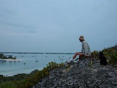
Harbor overlook
We stopped here for several reasons: it's someplace new to us, bad weather is on the way and we need to seek a safe place, we need to get the extension on our immigration permit and George Town is strategically located on the path of our return trip towards the north. We want to see all the things we've read and heard about.
Community Hotline
At 0800 each morning the cruising community holds a VHF radio "talk show" called a cruiser's net. The net starts off with the weather, foremost on everyone's mind, then follows with local business announcements of cruising interest, cruiser community information, a help needed segment, and cruiser arrivals and departures. People can call in with questions and answers and try to link up with their friends and other boats. For people who are winter residents here, it is really the start of their social agenda each day. They can find out about book and DVD swaps, volleyball games,volunteer projects, board game activities, beach exercise programs, special dining events, sharing cab rides, religious meetings, group discussions about chosen topics and other "must do" activities for the most gregarious souls. No man need be an island in George Town!
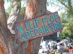
Island humor
Red Tape and Carbon Paper Blues
Our first order of business is to get the extension on our immigration permit. It seemed logical to us that the immigration office, usually tied in with the customs office, would be located in the government building, of the obligatory pink color. It is easy to find; it is the largest, cleanest building, and in the center of everything. We see the sign for customs, but not immigration so just assume that it must be the same office since it has been on the other islands we have checked in with in the past. We were second in line, behind someone who was trying to import an important repair part for their boat and really getting the run around from the woman behind the plexiglass wall with the little hole that is at your waist level, but her eye level, making for inconvenient conversation. Finally another woman comes out from behind the closed door and I rush over to verify that we are at the correct location. But of course not, immigration is no longer here, it is at the other end of town now, in a new office building, NOT a government building. Oh, that makes sense, not! Decentralization of government duties being attempted even in this tiny island community doesn't make it convenient for the people who use it the most.
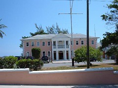
Government Building
Finding the new building was as easy as following one pothole to the next along the only road in town and then looking for the new office building with no architecturally unique island features that glaringly stood out from all the beat up hovels, most of which you can't tell if they are occupied or not. At least the inside of the immigration office was a pleasant tropical peach color with a cool ceramic tiled floor. There were even 3 cafeteria-looking chairs in a bare-walled waiting area that could have easily held 20 of those chairs without being crowded. The 2 people that came in after us just leaned up against the wall.
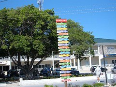
Colorful island signage
Fortunately the lady behind the counter, on a high stool, with no plexiglass window, was cheerful and helpful. She knew right away what was needed to extend our immigration permits and set out to get the paperwork. "Oh, I'm sorry" the nice lady said, "we only have 2 pieces of carbon paper, so only 2 of you will be able to fill out your papers; the other will have to wait until one of you finishes". No problem, mon, we be in no hurry; we be cruising in the Bahamas. I remarked to the two other people that we had dibbs on all, 2 sheets, of the office carbon paper, and they might have to wait a while. I had already had it on my list for our next visit to bring over some of the coveted legal sized carbon paper in hopes of immediately getting into the good graces of any government official we have to deal with.
Free Enterprise
The remainder of the morning was spent walking around the rest of the town, all of which surrounds Lake Victoria where the large dinghy dock is located, and thankfully well-protected from all the high winds we are experiencing. We browsed through some shops, visited the straw market ladies and their wares, and couldn't pass up a stop at Mom's Bakery van. Mom pulls into town proper 3 days/week selling breads and sweets; we bought a yummy marble pound cake. All of Mom's purchases come with free warm hugs and cheerful praises about how wonderful life is. I picked out the least yellow bunch of celery I could find at the grocery store in the corrugated metal building with no windows (purely functional, no island aesthetic appeal considered in its design) and an extremely overpriced bag of croûtons, a strictly luxury purchase for the guys. The grocery store maintains the dinghy dock and has a hose on the dock for free water for cruisers to fill whatever containers they can carry in their dinghys. Very importantly, the store also lets cruisers dispose of their trash in dumpsters conveniently positioned just past the front door to the store. Out with the old, in with the new in 5 easy steps.
Dinghy entrance to Lake Victoria
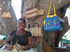
Straw market vendor
Regatta sloop
WiFi Rasta Man
After 2 days in the harbor Wayne finally managed to make contact with the operator of Harbor WiFi by reluctantly calling him on the cell phone at $2/minute when reaching him via VHF was unsuccessful. To get connected you have to purchase a "card" from him that has unique log-in and password characters to access the wifi system to get internet connections from your boat at anchor. At only $15/week it's one of the best deals in the whole Bahamas, when it works.
Wayne was told there were no cards this afternoon, come in the morning.
Wayne and I brave the windy, choppy conditions for the long dinghy ride across the harbor to go get the card. What seemed like easy directions, turn off the road by the yellow realty building and look for the antenna, required clarification from a person who I could see sitting in the back of a business with the front door ajar. Up the hill, he said. Up the hill we went, past Munchies, a local Rasta snack shack with strange odors other than food lingering in the air, and several colorfully dressed men with properly coiffed Rasta dos poking out from their knit caps. I said, "WiFi?" And they pointed farther up the road. Ah, we could see the antenna, but it was coming out of a, a what? house? shack? animal pen? abandoned building? I regretted not having the camera (too rainy) because this place is difficult to put into words. There was nothing about it to even suggest it could house anything hi-tech enough to connect the whole boating community to the outside world. There wasn't even a sign, and it wasn't clear that the building had an entrance from the road we were standing in. I told Wayne I would stand out by the road, near the chicken coop (or so I thought) with Ursa while he checked things out. Wayne craned around one side and voiced the inquiring hoo-yoo, hellooo, anybody there? "Just a minute" came from some part of the building. Right about then, a movement from the "coop" caught my eye, a large, scarred nose stuck out followed by a low, deep growl. "Hey Wayne, Ursa and I need to move farther out in the road". Then I could see the front of what was really a set of individual pens housing pit bull variety of dogs, who now could see me and Ursa. A white one got up and starting snorting and barking at my little sweetie. Then, to my other side, under tattered blue tarps, were more pens with more of the same beasts that started singing the same tune. By then the proprietor had come out to the gate and told them all to shut up. One look at his high, conical, colorful knitted cap with the wiry hair poking out from all sides and I dubbed him the WiFi Rasta Man.
Speaking over a chest high gate, WiFi Rasta Man told Wayne that he still hadn't been able to get the cards, but he had all the id numbers off the cards, and he would just write the numbers on the a piece of paper. No problem, mon, we be willing to go along with that. Meanwhile, he is giving Ursa a serious look over. I smile and say "Oh, don't worry she's not here for any competition with your dogs". He says "I like dat dog. How much do one of dem cost?" Then he leaves the gated area to come out to Ursa, slowly bending down to pet her and let her sniff him. No telling what she was smelling, but she was behaving nicely, despite the barking coming from under the tarped pens. He asked several questions about the breed and remarked that "One of dem be good for inside dee house" I asked him if he wanted me to write down the name of the breed so he could get the correct spelling to look it up, but he was confident he could easily find what he needed to know on puppyfinder.com, a website he frequented on a regular basis.
The Other Side of the Harbor
Now that you have an idea about the business side of the harbor, let me tell you about the other side, where we are anchored and like the best, closest to Stocking Island which separates Elizabeth Harbour from the open ocean of Exuma Sound. Cruisers have named all the parts of the island: Volleyball Beach, Monument Hill, Hamburger Beach, Sand Dollar Beach, Holes 0, 1, 2, and 3. Learn the names, so you know where to meet someone.
Meeting place
Stocking Island is tropical eye candy, sweet. The shorelines on both sides range from pure white sand to rocky outcroppings, fun to walk along and beachcomb for treasures from the sea. The hilly (up to 110') verdant land is covered with tropical vegetation of all sorts, from lowland salt pond area species to that which can easily survive a constant windswept environment. A few coconut palms dot the hill sides completing the real out island look. Breathtaking views of Exuma Sound or the harbor await the lucky and energetic cruiser who wants to hike one of the many trails (maintained by the cruising community) that transverse the island, running along the shores or along the spines of the hills.
Tools of the trade
We spent several mornings, dodging rain showers, to hike some of the trails. It would be difficult to say that one is better than another because they all offer something special. Getting across the island to the Sound side at low tide is worthwhile so you can see the interesting onshore reef formations and the sea life in the tidal pools. One trail is a 2.5 mile loop, taking you across the island, along a ridge fronting the ocean shore, down into a lowland area where you have to wade through standing water, all the way to the southernmost point of the island and then along the harbor side, where if you don't time the tide right, you have to wade out into the shallow of the harbor to round the island and complete the loop. We enjoy these walks much more than dodging the potholes and noisy, stinking traffic in town.
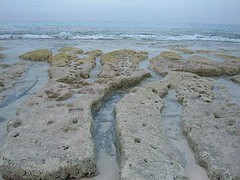
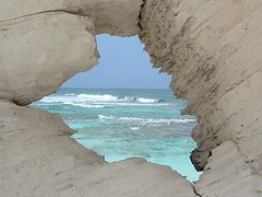
Beach reef
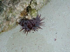
Sea urchin
All play and no work can turn FLUKE into a scow, so we keep up with boat chores, rain or shine, mostly rain during our stay here. Eddie (a.k.a. Water Boy) hooked up the roof drains to the water tanks, and we filled them all the way up. We hold 500 gallons and had depleted most of it before our arrival in George Town , so we thought we were going to have to buy water, but that issue has been taken care of. Early one morning when I took Ursa out to do her duty, the port deck drain had clogged up with hair and debris and the water was ankle deep on the port side upper deck all the way to the pilothouse door from the overnight rain. So, while it was steadily raining, I put on the foul weather gear and washed all the outside decks, getting off the salt and accumulated sea grime from a month in the out islands. FLUKE was shining brightly when the sun came out, and it felt so good not to have to walk on the gritty decks. Eddie and I reward ourselves by jumping off the pilothouse roof, 17' above the waterline, and laughing like teenagers when we pop back up to the surface. We argue what makes the biggest splash: my fat butt or Eddie's fat gut! That stunt is an annual tradition, a sure sign we still have the right stuff!
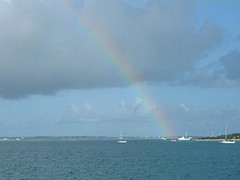
Elizabeth Harbour rainbow
Well, we finally arrived at the cruiser's mecca of the Bahamas. At the height of the winter cruising season there may be up to 600 boats seeking safety, refuge, companionship, reprovisioning opportunities, and several months of winter accommodations in Elizabeth Harbour, the large body of water lying between Stocking Island and George Town, Great Exuma Island. Since the "season" is over now we have avoided said congestion, yet by our cruising standards there are still a lot of boats here, perhaps 100. Now we can take up all the anchoring space we need without getting labeled as harbor "pigs".
Harbor overlook
We stopped here for several reasons: it's someplace new to us, bad weather is on the way and we need to seek a safe place, we need to get the extension on our immigration permit and George Town is strategically located on the path of our return trip towards the north. We want to see all the things we've read and heard about.
Community Hotline
At 0800 each morning the cruising community holds a VHF radio "talk show" called a cruiser's net. The net starts off with the weather, foremost on everyone's mind, then follows with local business announcements of cruising interest, cruiser community information, a help needed segment, and cruiser arrivals and departures. People can call in with questions and answers and try to link up with their friends and other boats. For people who are winter residents here, it is really the start of their social agenda each day. They can find out about book and DVD swaps, volleyball games,volunteer projects, board game activities, beach exercise programs, special dining events, sharing cab rides, religious meetings, group discussions about chosen topics and other "must do" activities for the most gregarious souls. No man need be an island in George Town!
Island humor
Red Tape and Carbon Paper Blues
Our first order of business is to get the extension on our immigration permit. It seemed logical to us that the immigration office, usually tied in with the customs office, would be located in the government building, of the obligatory pink color. It is easy to find; it is the largest, cleanest building, and in the center of everything. We see the sign for customs, but not immigration so just assume that it must be the same office since it has been on the other islands we have checked in with in the past. We were second in line, behind someone who was trying to import an important repair part for their boat and really getting the run around from the woman behind the plexiglass wall with the little hole that is at your waist level, but her eye level, making for inconvenient conversation. Finally another woman comes out from behind the closed door and I rush over to verify that we are at the correct location. But of course not, immigration is no longer here, it is at the other end of town now, in a new office building, NOT a government building. Oh, that makes sense, not! Decentralization of government duties being attempted even in this tiny island community doesn't make it convenient for the people who use it the most.
Government Building
Finding the new building was as easy as following one pothole to the next along the only road in town and then looking for the new office building with no architecturally unique island features that glaringly stood out from all the beat up hovels, most of which you can't tell if they are occupied or not. At least the inside of the immigration office was a pleasant tropical peach color with a cool ceramic tiled floor. There were even 3 cafeteria-looking chairs in a bare-walled waiting area that could have easily held 20 of those chairs without being crowded. The 2 people that came in after us just leaned up against the wall.
Colorful island signage
Fortunately the lady behind the counter, on a high stool, with no plexiglass window, was cheerful and helpful. She knew right away what was needed to extend our immigration permits and set out to get the paperwork. "Oh, I'm sorry" the nice lady said, "we only have 2 pieces of carbon paper, so only 2 of you will be able to fill out your papers; the other will have to wait until one of you finishes". No problem, mon, we be in no hurry; we be cruising in the Bahamas. I remarked to the two other people that we had dibbs on all, 2 sheets, of the office carbon paper, and they might have to wait a while. I had already had it on my list for our next visit to bring over some of the coveted legal sized carbon paper in hopes of immediately getting into the good graces of any government official we have to deal with.
Free Enterprise
The remainder of the morning was spent walking around the rest of the town, all of which surrounds Lake Victoria where the large dinghy dock is located, and thankfully well-protected from all the high winds we are experiencing. We browsed through some shops, visited the straw market ladies and their wares, and couldn't pass up a stop at Mom's Bakery van. Mom pulls into town proper 3 days/week selling breads and sweets; we bought a yummy marble pound cake. All of Mom's purchases come with free warm hugs and cheerful praises about how wonderful life is. I picked out the least yellow bunch of celery I could find at the grocery store in the corrugated metal building with no windows (purely functional, no island aesthetic appeal considered in its design) and an extremely overpriced bag of croûtons, a strictly luxury purchase for the guys. The grocery store maintains the dinghy dock and has a hose on the dock for free water for cruisers to fill whatever containers they can carry in their dinghys. Very importantly, the store also lets cruisers dispose of their trash in dumpsters conveniently positioned just past the front door to the store. Out with the old, in with the new in 5 easy steps.
Dinghy entrance to Lake Victoria
Straw market vendor
Regatta sloop
WiFi Rasta Man
After 2 days in the harbor Wayne finally managed to make contact with the operator of Harbor WiFi by reluctantly calling him on the cell phone at $2/minute when reaching him via VHF was unsuccessful. To get connected you have to purchase a "card" from him that has unique log-in and password characters to access the wifi system to get internet connections from your boat at anchor. At only $15/week it's one of the best deals in the whole Bahamas, when it works.
Wayne was told there were no cards this afternoon, come in the morning.
Wayne and I brave the windy, choppy conditions for the long dinghy ride across the harbor to go get the card. What seemed like easy directions, turn off the road by the yellow realty building and look for the antenna, required clarification from a person who I could see sitting in the back of a business with the front door ajar. Up the hill, he said. Up the hill we went, past Munchies, a local Rasta snack shack with strange odors other than food lingering in the air, and several colorfully dressed men with properly coiffed Rasta dos poking out from their knit caps. I said, "WiFi?" And they pointed farther up the road. Ah, we could see the antenna, but it was coming out of a, a what? house? shack? animal pen? abandoned building? I regretted not having the camera (too rainy) because this place is difficult to put into words. There was nothing about it to even suggest it could house anything hi-tech enough to connect the whole boating community to the outside world. There wasn't even a sign, and it wasn't clear that the building had an entrance from the road we were standing in. I told Wayne I would stand out by the road, near the chicken coop (or so I thought) with Ursa while he checked things out. Wayne craned around one side and voiced the inquiring hoo-yoo, hellooo, anybody there? "Just a minute" came from some part of the building. Right about then, a movement from the "coop" caught my eye, a large, scarred nose stuck out followed by a low, deep growl. "Hey Wayne, Ursa and I need to move farther out in the road". Then I could see the front of what was really a set of individual pens housing pit bull variety of dogs, who now could see me and Ursa. A white one got up and starting snorting and barking at my little sweetie. Then, to my other side, under tattered blue tarps, were more pens with more of the same beasts that started singing the same tune. By then the proprietor had come out to the gate and told them all to shut up. One look at his high, conical, colorful knitted cap with the wiry hair poking out from all sides and I dubbed him the WiFi Rasta Man.
Speaking over a chest high gate, WiFi Rasta Man told Wayne that he still hadn't been able to get the cards, but he had all the id numbers off the cards, and he would just write the numbers on the a piece of paper. No problem, mon, we be willing to go along with that. Meanwhile, he is giving Ursa a serious look over. I smile and say "Oh, don't worry she's not here for any competition with your dogs". He says "I like dat dog. How much do one of dem cost?" Then he leaves the gated area to come out to Ursa, slowly bending down to pet her and let her sniff him. No telling what she was smelling, but she was behaving nicely, despite the barking coming from under the tarped pens. He asked several questions about the breed and remarked that "One of dem be good for inside dee house" I asked him if he wanted me to write down the name of the breed so he could get the correct spelling to look it up, but he was confident he could easily find what he needed to know on puppyfinder.com, a website he frequented on a regular basis.
The Other Side of the Harbor
Now that you have an idea about the business side of the harbor, let me tell you about the other side, where we are anchored and like the best, closest to Stocking Island which separates Elizabeth Harbour from the open ocean of Exuma Sound. Cruisers have named all the parts of the island: Volleyball Beach, Monument Hill, Hamburger Beach, Sand Dollar Beach, Holes 0, 1, 2, and 3. Learn the names, so you know where to meet someone.
Meeting place
Stocking Island is tropical eye candy, sweet. The shorelines on both sides range from pure white sand to rocky outcroppings, fun to walk along and beachcomb for treasures from the sea. The hilly (up to 110') verdant land is covered with tropical vegetation of all sorts, from lowland salt pond area species to that which can easily survive a constant windswept environment. A few coconut palms dot the hill sides completing the real out island look. Breathtaking views of Exuma Sound or the harbor await the lucky and energetic cruiser who wants to hike one of the many trails (maintained by the cruising community) that transverse the island, running along the shores or along the spines of the hills.
Tools of the trade
We spent several mornings, dodging rain showers, to hike some of the trails. It would be difficult to say that one is better than another because they all offer something special. Getting across the island to the Sound side at low tide is worthwhile so you can see the interesting onshore reef formations and the sea life in the tidal pools. One trail is a 2.5 mile loop, taking you across the island, along a ridge fronting the ocean shore, down into a lowland area where you have to wade through standing water, all the way to the southernmost point of the island and then along the harbor side, where if you don't time the tide right, you have to wade out into the shallow of the harbor to round the island and complete the loop. We enjoy these walks much more than dodging the potholes and noisy, stinking traffic in town.
Beach reef
Sea urchin
All play and no work can turn FLUKE into a scow, so we keep up with boat chores, rain or shine, mostly rain during our stay here. Eddie (a.k.a. Water Boy) hooked up the roof drains to the water tanks, and we filled them all the way up. We hold 500 gallons and had depleted most of it before our arrival in George Town , so we thought we were going to have to buy water, but that issue has been taken care of. Early one morning when I took Ursa out to do her duty, the port deck drain had clogged up with hair and debris and the water was ankle deep on the port side upper deck all the way to the pilothouse door from the overnight rain. So, while it was steadily raining, I put on the foul weather gear and washed all the outside decks, getting off the salt and accumulated sea grime from a month in the out islands. FLUKE was shining brightly when the sun came out, and it felt so good not to have to walk on the gritty decks. Eddie and I reward ourselves by jumping off the pilothouse roof, 17' above the waterline, and laughing like teenagers when we pop back up to the surface. We argue what makes the biggest splash: my fat butt or Eddie's fat gut! That stunt is an annual tradition, a sure sign we still have the right stuff!
Elizabeth Harbour rainbow
Saturday, June 02, 2007
LONG ISLAND
May 10 – May 11, 2007
No, not New York!
Long Island, Bahamas is 45 miles mostly northeast from Water Cay in the Jumentos. We crossed some shallow areas over the Banks; our depth gauge beeped when we had less than 2' of water under our keel. We anchored in the southern part of Thompson's Bay near a settlement area called Salt Pond. Right now we are the only cruising boat in this area of the bay, but in the fisherman's area we can see several of the native vessels that we saw over in the Jumentos. One of which is actually sinking in the bow area, and they have 3 gas powered pumps on the upper deck actively pumping water out of the bilge to try to keep it afloat. Houses and business buildings are visible along the waterfront and in the hilltops, cars are noisily rushing by on the nearby road, and a couple of pieces of heavy equipment are grinding away at construction sites. It isn't thrilling to be back in civilization.
We learn that Long Island is 76 miles long and 4 miles wide. It was the third Bahamian island Christopher Columbus stopped at in 1492. There are 40 communities along the length of the island made up of people from varying ethnic backgrounds, descendants of slaves, pirates, French missionaries, and Greek sponge fishermen. The people we saw on our walk were pleasant and helpful answering the questions we asked. You have to look and listen to when most of them speak as their “accents” can be difficult to understand.
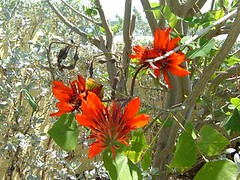
Tropical Blossoms
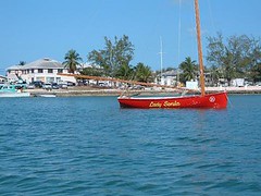
The local residents are preparing for their annual big event, the Long Island Regatta being held in a couple of weeks. Several of the Bahamian islands host a similar event. It is an opportunity for the residents to showcase their boat building and handling skills by competing in sailing competitions. The graceful little sloops have beautiful lines and magnificent paint jobs. It is a real honor to win an event in the regatta. I hope we will be able to time one of our trips to catch a regatta.
We are able to walk around the entire settlement in one morning. We see that the dentist works here a day or two a week, visiting other communities on the other days. Walking over to the windward side of the island we find that there is no community beach clean up effort – plastic garbage litters what would be a very picturesque beach, and oh, the usual number of washed up shoes.
Peaking out
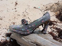
It's a real Versace!
We buy a few items at the tiny, but well-stocked local market. Overall, prices are double or triple for most items compared to what we would pay in the states. These stores make us realize how much we take for granted for the prices, selection, and convenience of every day shopping at home.
We also bought a phone card, .50/minute to call the USA, went to the ONE phone booth, and after 4 attempts managed to get a call through to my Mom and Wayne's Mom. Between having poor dialing instructions, busy Bahamian lines, and bad buttons on the keypad we were happy to get the call through at all. No problem, mon. Be happy.
No, not New York!
Long Island, Bahamas is 45 miles mostly northeast from Water Cay in the Jumentos. We crossed some shallow areas over the Banks; our depth gauge beeped when we had less than 2' of water under our keel. We anchored in the southern part of Thompson's Bay near a settlement area called Salt Pond. Right now we are the only cruising boat in this area of the bay, but in the fisherman's area we can see several of the native vessels that we saw over in the Jumentos. One of which is actually sinking in the bow area, and they have 3 gas powered pumps on the upper deck actively pumping water out of the bilge to try to keep it afloat. Houses and business buildings are visible along the waterfront and in the hilltops, cars are noisily rushing by on the nearby road, and a couple of pieces of heavy equipment are grinding away at construction sites. It isn't thrilling to be back in civilization.
We learn that Long Island is 76 miles long and 4 miles wide. It was the third Bahamian island Christopher Columbus stopped at in 1492. There are 40 communities along the length of the island made up of people from varying ethnic backgrounds, descendants of slaves, pirates, French missionaries, and Greek sponge fishermen. The people we saw on our walk were pleasant and helpful answering the questions we asked. You have to look and listen to when most of them speak as their “accents” can be difficult to understand.
Tropical Blossoms
The local residents are preparing for their annual big event, the Long Island Regatta being held in a couple of weeks. Several of the Bahamian islands host a similar event. It is an opportunity for the residents to showcase their boat building and handling skills by competing in sailing competitions. The graceful little sloops have beautiful lines and magnificent paint jobs. It is a real honor to win an event in the regatta. I hope we will be able to time one of our trips to catch a regatta.
We are able to walk around the entire settlement in one morning. We see that the dentist works here a day or two a week, visiting other communities on the other days. Walking over to the windward side of the island we find that there is no community beach clean up effort – plastic garbage litters what would be a very picturesque beach, and oh, the usual number of washed up shoes.
Peaking out
It's a real Versace!
We buy a few items at the tiny, but well-stocked local market. Overall, prices are double or triple for most items compared to what we would pay in the states. These stores make us realize how much we take for granted for the prices, selection, and convenience of every day shopping at home.
We also bought a phone card, .50/minute to call the USA, went to the ONE phone booth, and after 4 attempts managed to get a call through to my Mom and Wayne's Mom. Between having poor dialing instructions, busy Bahamian lines, and bad buttons on the keypad we were happy to get the call through at all. No problem, mon. Be happy.
Subscribe to:
Posts (Atom)


