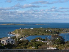
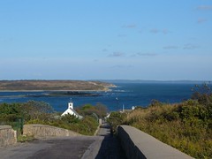
In the last posting of our BLOG we told you that we were getting hints from Mother Nature that our time to head south had arrived. Well, we got up on the morning of October 14 to find ice on the aft deck of FLUKE! We were so. . .o cold. Like the geese we had been seeing flying overhead in vee formation, it, too, was truly our time to follow them south.
CUTTING THE CORDCharles and Louise invited us to go with them to a dinner at the local VFW on October 14. It was a fun time with family style dining and lots of food to eat, and thank you, a warm building. We all bought tickets to their customary raffle, and Eddie won the raffle! Even if he didn't win, we on FLUKE, are still winners of a wonderful 2006 adventure.
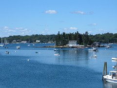
At first light the next morning we dropped the mooring lines at Old Lyme Marina to head out into Long Island Sound. Windy weather with rain and high seas the previous couple of days made us to decide to travel in the Sound and take the East River in NYC out to Sandy Hook, NJ. The weather forecast had indicated we should have good traveling weather in the Sound. Unfortunately that proved to be false, and we had somewhat pounding seas and cold temperatures that fogged up the windows 80% of the day, making it a tiring run.
We had made the decision to try to anchor close to the north side of the City so that we could get an early start through the East river with a favorable current. We chose City Island, NY. To our relief, we were the only boat seeking anchorage, so we had our pick of the limited room available. As we were trying to anchor, with me at the helm and Wayne and Eddie on the foredeck in position to deploy the anchors, I could hear voices coming out of our speakers, not on the VHF. It was annoying and puzzling, and E & W accused me of hearing things! It turned out that we were anchoring right next to a radio station tower and somehow we were picking up some of their communications. We had good holding and felt secure for the night.
IT ALL BLENDED TOGETHERMonday, October 16 at 0730 had us getting underway towards the East River. Our transit through the City went without incident: minimal harbor traffic, favorable current, smooth waters, and fairly clear skies. The skyline views were just as thrilling as on our northbound transit. We could easily see the building that the NY Yankees pitcher had flown his plane into the week before, and we wondered how he managed to fly between the buildings before hitting the one he ended up hitting.
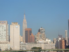 Find the Helicopter in New York City
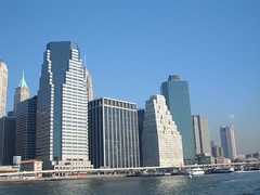 East River Skyline
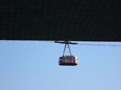 Aerial Tram Over the East River
We rounded Sandy Hook and headed out into the Atlantic Ocean with the intent to travel all day and all night, thus avoiding having to stop somewhere in NJ this time. Twilight came a lot earlier than on our northbound transit, when the days of summer had so much more light. Our oasis in the night was Atlantic City which we could see for many miles approaching and passing. We were traveling 8 miles offshore most of the time, so we were able to see some of the bigger buildings fairly clearly. One building was particularly fascinating: the whole building changed through all the colors of the rainbow and even had pattern changes, one of which made the whole building look like an American flag.
As daylight began to approach, weather and sea conditions worsened, and FLUKE began getting bounced around, making its crew feel pretty uncomfortable. Daylight brought a fine misty rain that stayed with us all day, making us cold and damp. Traveling up the Delaware River was a dreary experience, the montony broken up by having to keep our eyes carefully alert watching for the enormous freighters, tugs and barges, and cargo ships that were transiting the same area.
 Waiting for Lunch on the Lido Deck
We couldn't wait to get into the C & D Canal (the shortcut connecting the Delaware River to Chesapeake Bay) where we knew that the water would be calm. We had a peaceful, but damp transit all the way to our anchorage at Veazey Cove on the Bohemia River where we had to deploy the anchor in the cold rain. Fortunately Eddie had a new rainsuit that worked well for that job. We had reached a new travel record: 234 nautical miles with a 34 hour straight run. We were dead tired and needed a good night's rest.
THE VEILED GREETING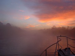 Foggy Sunrise
Mother Nature gave us a veiled greeting to the Chesapeake on October 18, 2006. We awoke to find FLUKE engulfed in thick fog. We delayed pulling up the anchor, but even when we did get underway visibility was still less than 0.5 mile. We had to rely solely on radar and our electronic charts in hopes of staying out of the way of the gigantic commercial vessels, other cruising boats, and remaining in deep water. We had our fog horn set to sound regularly: 6 eyes and 6 ears were in full operation. The fog stayed with us until 2:00 p.m. Some visual excitement ensued when we had to detour around a sailboat race. We came a bit to close to a couple of the boats and their occupants were yelling and signally for us to get out of their way; we knew we would not jeapordize their progress in the race. We set the anchor in the Rhode River, with the sun out, and we felt the warmest we had been in 6 weeks!
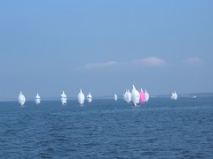 Chesapeake Sailboat Race
October 19, 2006 was Carol and Wayne's 28th wedding anniversary. I don't know how he has stood me that long! Anyway, now that we are heading south in the Chesapeake it is apparent that the fall migration of cruisers heading south, mostly to Florida and the Bahamas, is in full swing. There is so much radio chatter between boats with questions and comments pertaining to getting from here to there, boat types, destinations, and summer happenings. When we set the hook for the night at Sandy Point on the Wicomico River there were 12 boats in the anchorage.
The next day we endured a miserable pounding ride the whole day. We were too shaken up to eat lunch underway, and by the time we finally got the anchors set in Mobjack Bay at the southern end of the Chesapeake it was almost time for dinner. THE CREW WAS HUNGRY!!
SOMETHING FOR NOTHINGWe have an 0530 wake up call on October 21 so we can get underway ASAP and try to make time to Great Bridge where a limited number of free docks are available. However, between our point of origin and those docks we will have to traverse the busy harbor sections of Norfolk and Portsmouth. We will have to deal with needing 4 bridge openings and going through one lock which can add a lot of time to the passage, especially if bridges have restricted openings, like only on the hour or half hour. Having to wait in the waterway with other boat traffic, current, and wind pushing us around can by very trying.
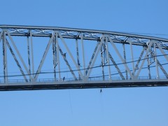
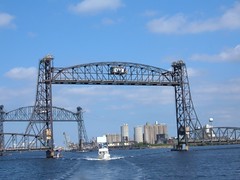 Jordan Bridge Norfolk
We successfully navigate through the bridges, pass through mile zero on the ICW (meaning we are now entering the "ditch" as it is referred to by cruisers), and head into the Great Bridge Lock. The GBL separates the salty tide waters of the Norfolk area from backwaters of the Albemarle Sound of North Carolina. It is the northern end of what is known as the Albemarle and Chesapeake Canal, the alternate route of the Dismal Swamp Canal which we took on the voyage north. The A & C Canal is maintained to a depth of 12', twice that of the DSC; really great for us. But that doesn't come for free: there is an enormous amount of barge traffic, some of which can almost take up the whole waterway. At least the barge captains are really great about trying to help us pass them, offering suggestions for speed, passing positions, and even laying up.
As we pull out of the Great Bridge Lock we can see several boats already at the free dock on our side of the Great Bridge. Hoping there is space for us we call ahead on the radio to "any boat at the free dock" to ask if there is room for us. We get an affirmative, and the crew of FLUKE breathes a sigh of relief. We have the rest of the afternoon to relax, do boat chores, go ashore for some shopping (critical needs, like DQ Blizzards), watch the activity at the Great Bridge area, and even order a pizza.
The town of Great Bridge was the site of a pivotal battle in the Revolutionary War that took place on December 9, 1775. The Patriot troops defeated the British when they were trying to get through the swampy area of Great Bridge, forcing them to evacuate Norfolk. The defeat demoralized many Loyalists, converting them to the Patriot cause. Today a beautiful new bridge (one of the prettiest small bridges we've seen) and park stand tribute to that effort.
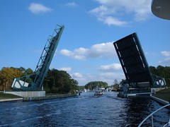 Great Bridge Bridge
As the 6:00 p.m. hour approaches, traffic through the lock gets heavy. Two barges compete for space, crowding out some fellow cruisers, forcing them to wait until the 7:00 p.m. opening. That means they will have to continue on in darkness or stop at the free dock, not knowing if space is available. We of FLUKE can relate to the anxiety they must be feeling, so we send a VHF call to "cruising boats in the Great Lock wanting free dock information". We tell them that two spaces are still available at the dock, and we will help them secure their lines. They are SO relieved. We meet them on shore with flashlights in hand to get them tied off. Help others not expecting it.
I never combed my hair today! Cruising turns you into a real slouch.
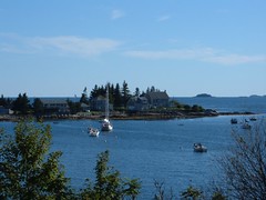
SEEKING PROTECTIONA windy frontal system was dogging us on October 22 and 23, but we still elected to anchor out in protected harbors for those nights. We had two bow anchors out on the 23rd and the flakey winds got them crossed in the night, but we were able to untangle them successfully without too much conflict.
By the time the 24th rolled around winds were forecast to be in the 30mph range during the that night and possibly the next, so we decided to seek refuge at a marina so we could sleep during the night without having to worry about FLUKE taking off under the ill guidance of the wind. We went in to Whittaker Creek Marina in Oriental, NC. Despite having barely enough water to get to their docks, we fueled up ($2.23/gal), pumped out the holding tank, gave FLUKE a much needed hosing off, and tied her up tight.
All the radio chatter and a walk into town where the other marinas are located indicated most other boaters were trying to secure themselves for the windy forecast. Oriental is a boater friendly little town, having about only 800 residents, but 2400 boats registered there. We see many cruising boats with Oriental as their home port. A friendly woman pulled over and offered us (including Ursa) a ride back to the marina, which we happily accepted. Not that we couldn't have used the walking exercise!
TAGGED BY A WARSHIPThe forecast for October 25 sheds an optimistic shine to our morale. We think that the winds have subsided enough and the seas offshore look small enough for us to head out of the inlet at Beaufort, NC and make an overnight crossing to Charleston, SC. We aren't in a hurry to get anywhere, but we would like to avoid the congestion, shallow water, and slow bridges in the areas we experienced along the stretch of the ICW between Oriental and Charleston (look back in the log and see what I'm talking about).
With our positive attitudes we exit the inlet and head out to sea. We will have to travel about 25 miles offshore most of the time, so that we can avoid the treacherous shoals of Cape Fear, NC. That means we won't have the comfort of those shore lights during the night. I know I will miss them.
Within an hour of exiting the inlet we see a lot of activity from large ships looming on the horizon. As our gaps close, and we hear the radio chatter we realize that there are naval maneuvers taking place involving 6 warships, helicopters, and hovercraft. Warship #5 contacts us on the VHF and tells us they want to reposition their ship and don't want us to be near their intended path and tell us the heading they want us on until they are where they want to be. We oblige and alter our course even though it is in the wrong direction for us. Like what choice do we have?! After about 20 minutes I begin whining about how much time we are wasting, and seeing Warship #5 still going in its original direction, I insist we contact #5 and ask what's going on before we get halfway to France. #5 responds "oh, we've had a change of plans and won't be making our turn; you can resume your original heading". Right. They wouldn't have cared if we saw the Effiel Tower.
We have a beautiful sunset, with a green flash, but darkness brings sloppy seas and an uncomfortable ride. I am thankful to have the crew of COSMO, on a large sailboat traveling just ahead of us, to chat with throughout the long night. It is a relief to see the sun rise and bring calmer seas. Even better is getting into Charleston harbor where the waters are more settled.
MAKING THE BEST OF BAD WEATHER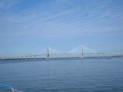 Arthur Ravenel, Jr. Bridge
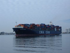 Passing a Big One
High winds and rain kept us dock bound at the Cooper River Marina in Charleston for 3 nights. The day after we arrived the rain set in for the entire day, a light drizzle with a driving wind. Eddie and I hitched a ride into town with a marina staff member and visited the South Carolina Aquarium. Its theme is "From the Mountains to the Sea". Different aquatic habitats are displayed showing life in mountain streams, piedmont rivers, coastal swamps, salt marshes, and ocean waters. Plus there was a special Amazonian exhibit. Overall, a great place to spend a rainy day.
While the rain had let up by October 28th, the wind hadn't, so we were still land bound. Sailboaters with a rental car gave Eddie and I a ride into town. Our goal was to walk to sightsee some of the older sections of the city. We happened upon an old church where a funeral was taking place. One of the older funeral attendees had his car stop running in the middle of the street so we pushed him 2 blocks to a nearby parking lot. We were so glad it wasn't uphill. Feeling we did a good deed, and having spent all our energy, we pigged out on a good, too expensively priced lunch, in a quaint cafe. With our systems recharged, we continued onward browsing through the vendor wares at The Market, where Eddie bought one of the sweetgrass baskets. The skills to make these baskets were brought over from Africa by the black slaves who were brought here to work in the rice plantations. The tradition continues today with a village industry handed down through the generations, producing baskets that are both utilitarian and works of art.
POETRY IN MOTION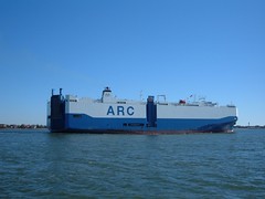 Automobile Transport Ship
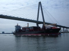 Going Under the Bridge
FLUKE and her crew exited Charleston Harbor the morning of October 29, 2006 and headed out to sea again for an all night crossing to St. Marys inlet at the Florida Georgia border. Finally, we had perfect night weather with calm seas, light wind, and a beautiful half moon that kept the seas lit a shimmering silver glow until midnight. To pass my midnight shift, writing in the darkness of the pilothouse, here is my creation, reflective of my thoughts at the time:
The Night Crossing
Tick tock, tick tock.
The ship's clock chimes twelve o'clock.
Each of the men has gone to his berth,
Dreaming with thoughts not of this earth.
Now I alone sit at the helm
To keep watch on the ocean's realm.
Staying awake is not hard to do
For orders I have to follow through
The radar screen shows a few blips,
But none of them bring shrieks from my lips.
I know how to fix and track,
And keep watch both front and back.
Our lat. and long. are right in line,
So I know FLUKE's position is just fine.
I'll be keen to the cross track error,
So the guys don't awaken to a state of terror.
Speed over ground is a steady seven;
We don't care that it's not eleven!
The VHF has little chatter,
But for me, at this hour, it doesn't matter.
All the gauges are positioned right
As the moon slips slowly from my sight.
Now I can enjoy the solitude of the ocean deep
While I wait for my turn to sleep.
TWO WHEELING ITWe pulled in to St. Marys inlet at 0900 on Oct. 30, very tired, but glad to be dropping the hook in familiar waters and looking forward to a land adventure. We were disappointed in our failed attempt to get into a new anchoring spot, but it was low tide and we ran aground twice so resorted to anchoring where we did on the way north.
The next day we packed a picnic lunch, offloaded the bicycles into the dinghy and headed to shore. We rode 7 miles along the hard packed oak canopied road, enjoying the sights and sounds of the nature's beauty. Wild horses were numerous, some scampering out of our way.
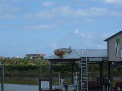
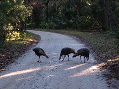 More Turkeys (Besides the 3 on Bicycles!)
Our destination for lunch was Plum Orchard, a Georgian Revival style mansion. Andrew Carnegie built Plum Orchard for his son George in 1898. Carnegie family members donated it to the National Park Foundation in 1971. Today, it is being renovated and will be open for public tours when completed. The building contractor we spoke with said that we could look around inside, so we took a peak at our leisure, marveling in the beautiful woodwork, enormous rooms, and fascinating layout of the home. We were surprised by the opulance of the main quarters compared to the absolute plainness of the rooms and back corridors used by the wait staff.
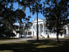 Plum Orchard Main House
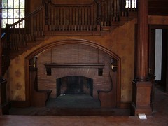 Cozy Sitting Area in Plum Orchard Mansion
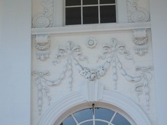 Exterior Artwork on Plum Orchard Mansion
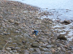
On the return trip we sidetracked through the undulating coastal dunes to the seashore. To our surprise, there was a beached marker buoy at the high tide line. We had always passed them in the water, but it was interesting to get such a close up view to see how big and heavy they are, how they are weighted, and how they are powered. Like children, we just had to climb up on it!
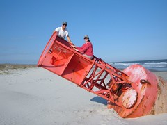 Beached on a Buoy
Our wonderful day was topped off with 3 flat tires from sand spurs and 15 miles worth of sore legs, but it was worth the price!
FAMILY REUNIONNov. 2 heard the radio alive with chatter from all the boats heading into St. Augustine, the nation's oldest city. It is usually a popular stop because of all the tourist amenities it has to offer, but this day brought concern from boaters heeding the weather forecast for later in the day: extremely high winds, up to 40 mph. Everyone was seeking safe haven. We had planned to spend the night anyway at the Conch House Marina because Wayne's parents live in town, and they had not yet had the opportunity to see FLUKE, and it had been almost a year since we had last seen them anyway.
An early arrival to the Conch House allowed us to have Wayne's Mom over for lunch. For dinner, we had Wayne's Dad and his wife and Wayne's brother-in-law. It was the most company we had had at any one time during the 2006 Voyage. It was fun seeing everyone, catching up on news, and answering questions about the Voyage and FLUKE.
Extremely bad weather persisted through the following day, forcing us to spend another night at the dock. At $130/night it was not our first choice, but we couldn't have left the slip if we wanted without damaging our boat and who knows how many others. Water was crashing over the dock; we kept checking our boat lines several times a day.
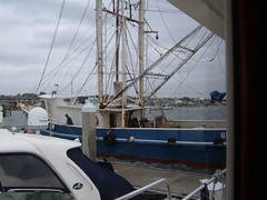
Late morning brought a surprise to our eyes. A shrimp boat was edging its way toward the marina, like it was wanting to come into the face dock on the opposite side of us. You have to just see the contrast of this beat up, dilapidated hulk of steel and cables to the shiney white fiberglass of the yachts at this high end marina. It was just too out of place! However, it inched its way into the dock and began to try to tie off. It wasn't long before the marina staff members arrived at the scene and started yelling at them to go away. The captain said he had no where to go under the current weather conditions (seas were at 15') and by then couldn't turn back into the wind to even get off the dock. Everyone was getting soaked from the water splashing over the dock. Marina staff continued to insist he leave. He tried to turn off the dock, breaking a horn off a cleat and sending it flying like a lethal weapon and stripping the rub rail off the dock, but he couldn't make the turn and decided to sit tight. The police and Coast Guard showed up, followed within a couple of hours by three men from the Customs and Border Protection. The story was that the shrimp boat was being delivered from Texas to Cape May, NJ and the weather had forced them inland. Later a tug came and took them off the dock to a remote anchorage.
 Any Port in a Storm
While the shrimp boat incident was occurring, 2 Sea Tow boats had arrived on the scene to move a large wooden Trumpy (classic old style yacht - the Presidential yacht Sequoia was a Trumpy) that was sitting on the same face dock, getting beat up from the wind. The tow boats had to pull from bow and stern to keep control of the Trumpy while it got moved to a safer location.
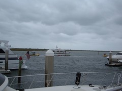 Two Boat Tow
Feature #3 showed us a moderate sized motor yacht with lots on top windage and no weight underneath the keel trying to get into an inner area slip. The wind kept pushing the boat sideways until it pushed over a piling altogether and went right over it. The captain gunned the engines hard (we have no idea how he didn't wreck a prop) to get back into open water. We wondered how anyone could even be out traveling under those conditions, much less think they could dock into a tight slip.
Needless to say, the bad weather wasn't boring for us and by late afternoon it was time for us to disembark, dodge the dock waves, and walk over to Wayne's Dad's house for one of his yummy specialties, chicken pie. We always arrive hungry, pig out, and then complain that there is always too much to eat. It was no different this time. The sad part is that when everything is so good, you have to try it all. Plus, there is never just one thing for dessert, so you even end up eating multiple desserts; like you need them by that point in the meal. Obviously we never take our friend, Will Power, with us.
THE FINAL APPROACHNovember 4 brought winds down to the 15 - 20 mph range, so we got our courage up and exited our slip at the Conch Inn without damaging us or anyone else.
We anchored out at Rockhouse Creek again, just off the inlet in Daytona. The wind was blowing so hard this time the noseeums couldn't feast on us like they did when we stopped there on the Voyage north. We dropped the hook the following night just off the north side of the Melbourne Causeway, a short sniff away from the home port, but too far to make that in the same day.
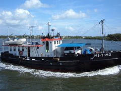
 ICW Sight
So, here it is, November 6, 2006. My crewmates have relieved me from helm duty so that I can finish this section of the blog. We should be in the home slip around midday. We are being passed by a multitude of fast motor yachts, the most that have passed us the entire summer. A few comment that we are almost home when they see VERO BEACH,FL on FLUKE's transom.
 Taking the Car For a Boat Ride
What lies ahead? We have much to do to get our land home in order; we plan to sell it as we have realized that we cannot emotionally or financially take care of both FLUKE and a land home. There are many seas to cross and ports to visit. We need to remain at sea while we are able. Handling FLUKE takes a lot of physical and mental stamina, which most of our current readers know, doesn't last forever.
FLUKE has needs to attend to: a thorough cleaning and waxing, haul-out for bottom inspection and stabilizer maintenance, and some minor repairs and changes for future voyages.
Stay posted to the BLOG. We plan to post a financial summary of the 2006 Voyage North that we think most readers will find interesting