Time For a Schedule
Birthdays are always on the same schedule, year after year, whether you want one or not. So our last day, Sept. 18, at the Eddy Marina was spent celebrating Wayne's 56th birthday: chocolate cake, chicken enchiladas, and an Old Lyme Marina hat (he really needed a new hat; I'd been threatening to throw his favorite old one, heavily ladened with sweat and hair oil, overboard since we left Florida!).
We needed to allow some time for potentially poor weather when we would not be able to travel and still get to Solomons, MD by Oct. 4. So, we left at 0600 on the following day. Luck was with us as we had an outgoing current. We don't want to travel on the Sheepscot River at a high tide because the lobster buoys get pulled under the surface of the water, and then we can't see them, making it more likely that one or more at the same time could get tangled in our prop.
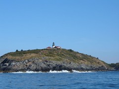
Seguin Island Lighthouse
3' swells off the port beam made for a rolly start to our southern journey, but we still enjoyed seeing a myriad of ocean creatures: whales, schools of tuna, a shark, and an ocean sunfish. Since I couldn't get my own photo of this unusual creature I am posting one I found on line because you have to see one to believe my description when I tell you it looks like a fish that has been compressed from end to end. They can get up to 5000# in weight and 11' long. Since they like to lay right at the surface (sunfish!) they can be a hazard to boats. King Neptune was with us all day as we managed to safely run over 2 lobster buoys with just a loud thwack sound on the hull and no fatal prop entanglements. Since we were able to leave so early we made it all the way to Isles of Shoals, on the Maine/New Hampshire border. Calm conditions meant we could pick up one of the free moorings at 1630, making for a long day.
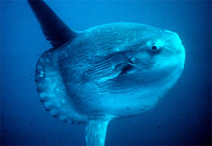
Ocean Sunfish
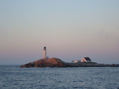
White Island, Isles of Shoals
We anchored at Provincetown, MA again. The harbor was much less crowded than during our visit in August. A lot of the moorings had already been removed for the winter. Tour boats were still operating, and there was the usual recreational boating activity associated with this lovely harbor. Noisy terns were feeding on baitfish and roosting on untended boats.
Cute Little Visitors
Despite having a perfectly smooth ride across Cape Cod Bay we were still anxious to get into the Cape Cod Canal, one of our favorite places to rubber neck; there is always something happening. Sept. 21 brought a fisherman's dream day. Stripers were hitting on baitfish, making the water white, sometimes kicking up spray 4-5' high. Many people were fishing from shore, and I could see them hauling in fish. Fishing from boats in the canal is prohibited, but it was fun for us just to look in the water at the huge schools of fish, watch the feeding frenzies and the other people reeling them in.
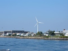
Massachusetts Maritime Academy Windmill
We had discussed making it a point to try out new places to anchor when conditions were favorable and our daily cruising schedule made it feasible. So, we decided to anchor at the Point Judith Harbor of Refuge. This “sheltered” anchorage, on the boundary of Rhode Island Sound and Block Island Sound, is just a mile of huge granite rocks in the shape of a big V. Getting in behind the V gives mariners a chance to get out of bad currents or rolling seas into some protected water. We found the holding to be good, but there is quite a bit of roll from commercial and recreational boaters that use the area to go into Point Judith, RI. It would not be a place to stop if the winds and seas were really high. We liked stopping here under calm conditions because it is easy to get out of in the morning when it is still dark, and with a stellar weather forecast we wanted to try to make it all the way to Cold Springs Harbor the next day, where we felt comfortable going into in the dark if we needed to.
What Is That Smell?
That question usually has negative connotations when uttered on a boat. When we woke up early on Sept. 23 in Cold Springs Harbor we could smell sulfur in the salon area, a truly bad sign since the engine room lies beneath that area. Inspections revealed that the generator battery had shorted out and was boiling the battery acid in the battery box. Not a good thing, but a fire would have been worse. So much for an early start.
Wayne called Tow Boat US to ask for advice and was told to contact Oyster Bay Marine Center, right around the corner from where we were anchored. OBMC said we could tie up to their face dock and look at the batteries they had in stock. While Wayne was in the store I took Ursa for a walk, her first trip to land in 5 days, so she was really excited. Eddie went off to ogle Billy Joel's beautiful, classic commuter boat, Vendetta, which was tied up at the end of the dock.
Wayne found a battery, smaller than ours, but he thought it would work. I went back to FLUKE when I saw Wayne heading in that direction. We had all used one of the side gates to get off the boat, so when I got back on with Ursa, I left it open for Eddie, whom I could hear out on the dock. I stepped inside to change my land shoes back to my boat shoes, leaving Ursa in the cockpit.
Since the wind was pushing us on the dock, the dock crew helped us get off the dock and we slowly pulled away. The OBMC has a very long face dock, and as we were slowly coasting by it Wayne asked where Ursa was since she wasn't up in the pilothouse, her usual place when underway. I looked out to see her running down the dock watching us pull away until she got to the end and just stared at us with a frantic “what about me?” look on her face. What we guess happened was that Ursa jumped off the boat when I went in to change my shoes and ran to the opposite end of the dock where Eddie wasn't looking, and he stepped aboard and closed the gate, not that she would have even considered following him back on the boat.
So, our second panic of the day ensued. Our first fear was that she would try to run off the dock area back up to land. Fortunately, the docks are set out in the bay by a long gangway, so a quick call to OBMC on the VHF asking them to keep her from leaving the dock was the first priority. We told them we would circle back to the face dock to pick her up.
By the time we had gotten back to the face dock another boat had already pulled into to our previous position. With the wind blowing quite a bit, and room limited, docking wasn't going to be as easy this time around. The girl who had captured Ursa saw this and suggested she bring Ursa out to us in the OBMC launch and do an on water transfer. We gratefully accepted her offer, and she made a skilled landing alongside FLUKE, and Ursa willingly jumped aboard.

Passing on the East River
Red Tape
We felt we still had enough time to traverse the East River, NY Harbor and get over to Horseshoe Cove in the Sandy Hook area before dark. However, the course was altered again when a Coast Guard vessel pulled up along side and told us that the north side of Roosevelt Island was closed for security reasons (this happens when there is an event at the United Nations building, and the Iranian president just happened to be in town, so we figured it was related to that), and we would have to pass on the south side. Since there is a low clearance bridge and narrow channel on that side we never go that way, but today we didn't have a choice. We found we could clear the bridge and just carefully watched the cluttered markers underneath and made way with no problem. It was interesting seeing the industrial side of the East River.

Keeping a Landmark
When we passed lower Manhattan there was a flurry of activity around a classic, elegant motoryacht filled with men wearing dark suits: security helicopter overhead, Coast Guard and NYC police boats, making sure no other vessels could get close to the motoryacht which headed up the north side of the East River. It was another interesting moment to this “exciting” day. Oh, it was also the first day we didn't have to wear sweatshirts!
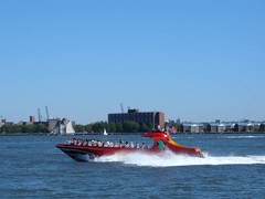
Fast NYC Harbor Tour

Lower Manhattan on a Clear Day

Resting Giant
Seeing the Light
Traveling along the New Jersey coast is a challenge to trawler cruisers. It takes at least 15 hours to get from Sandy Hook to Cape May , the two logical places to stop, meaning in late Fall you have to leave and arrive in the dark. We don't like the idea of anchoring in Cape May, so we have tried different methods to avoid it. The only safe inlet for us to use would be Atlantic City, and we have also avoided going in there because of limited anchoring area and extremely high dockage rates.
Because sea conditions were so benign on Sept. 24, we decided we would go into Barnegat Inlet and check out an anchorage area we had read about in other cruising logs.
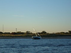
Bad Boating Day at Sandy Hook
Since the inlet had recently been dredged and properly marked, getting in was easy. However, we could clearly see the shoaled areas which, under high sea and outgoing tide, make this inlet dangerous even for those boaters with local knowledge and would be prohibitive for us under those conditions. Following the narrow, somewhat confusingly marked inner channel to the anchorage was accomplished without anguish even coming in at low tide. However, the “anchorage” has quite a few moorings, used by locals only, limiting the space to drop an anchor. Since it was only about 1300 we arrived ahead of other cruising boats, thankfully. Trying 2 different spots, we tried setting the Delta 3 times and then used the Super Max before we could even get any type of holding, taking about 1.5 hours for this task. When we pulled up the anchor, it was covered with stinking, sticky mud! Under calm conditions this situation was OK, but that's all I can say.
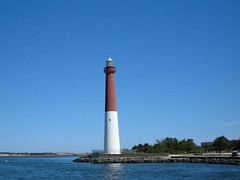
Barnegat Light
I was happy to make the 12 hour passage to Cape Henlopen on the east side of the entrance to the mouth of Delaware Bay. Seas were calm until we got to the mouth of the Bay where the seas of the ocean and bay merged creating confused, bumpy water. That's when a blue fish hit the trolling line, and we had to carefully watch the passages of the ocean going tankers and freighters entering and exiting the Delaware Bay. Everything always has to happen at once!
Cape Henlopen has two large breakwaters for a harbor of refuge and to help provide safe landing for the Cape May/Cape Henlopen ferry. Most cruising boats don't try this area because it is on the west side of the bay, and they elect to go into Cape May. It worked out fine for us though because it was easy to get into and out of and had good holding off the west side of the inner breakwater close to the ferry terminal. We wanted to check it out in case we decide to go offshore along the Virginia coast instead of having to go through the Chesapeake.
So, on Sept. 26 when we set anchor in the mouth of the Bohemia River, after transversing the C & D canal, we felt we were “home free”, i.e., we had made it to the Chesapeake and would be able to get to our Krogen rendezvous with time to spare. Gone were all the high pitched screeches from the ospreys we heard in July that had been nesting on every channel marker now to be replaced with the deep honking and swooshing wing sounds of the gigantic flocks of Canadian geese that were flying overhead. We breathed a sigh of relief with a contented feeling of good passages made, more things learned and another chapter of cruising about to begin.


0 comments:
Post a Comment