Friday, October 30, 2009
GROUNDED IN THE CAROLINAS
October 21-26 2009
We left the free dock at Great Bridge in time to make the 0700 bridge opening. Less than 100 yards through the bridge we pulled into the fuel dock at Atlantic Yacht Basin to take on fuel and water. We knew we needed to get the water hooked up right away because on the way north when we had stopped here to get fuel and water the water flowed so slowly it took forever to fill the tanks. AYB employs an interesting strategy with their water hose. The measly little 5/8” hose is so kinked and worthless no one would ever be interested in stealing it or accidentally taking it with them. While we have our own water hose that we use to enter the boat and hook up to our tank we still have to use their hose to get over to the boat.
So, I monitored the water tank while the guys took care of the diesel fuel. On August 8 we paid $1.97/gal. and this time we had to pay $2.43/gal. We only took on 250 gals, but that, and what we already had in the tanks, will get us back to the home dock. I never did get to finish topping off the water tanks; we would have probably had to stay there until lunch for that. I shouldn't complain since the water is free.
We had clear skies and no wind to make our run through the marshes of Virginia, Currituck Sound, Albermarle Sound and then into the long stretch of the Alligator River. I like traveling through those areas under good conditions. It is peaceful, scenic, and if it isn't the weekend, boating traffic is not bad.
We ran until dusk, and since there was no wind, we just pulled off the main waterway by Red 28, north of the beginning of the Alligator Pungo Canal, and dropped the hook. 14 other boats were anchored within a couple of miles from us. We tied a trip line with a float attached to the anchor. The area has a lot of sunken logs. If our anchor was to get caught on one we may not be able to pull it up with just our windlass. Using the trip line we would be able to grab the line and pull it in a different direction and hopefully free the anchor from the bottom.
With no towns in the vicinity, and surrounded by miles of swamp, the night sky was the blackest black. The stars showed up brilliantly in the clear sky. A crescent moon slipped out of sight, leaving the night to the stars alone. A beautiful sunrise greeted the glassy waters of the morning, reflecting the colors of the sky and the silhouettes of the trees along the shore. We were relieved not to have to use the trip line as the anchor came up with no problem.
When we rounded the southern point and entered into the confined waterway at the beginning of the Canal mist clung to the gnarled cypress trees and low lying swamp vegetation. I love that habitat, and always think the mist gives it a magical quality. The morning is a buzz of activity, and if you keep an eye out you will see a variety of wildlife. We have always seen at least one bald eagle in the neighborhood. We had a big surprise on this trip to see a pod of dolphins. The swamp is freshwater, and Albemarle Sound is 25 miles away, and then it is another few miles to the ocean.
Since we wanted to get an early start and the waters were calm, Wayne made pancakes underway. It was one week ago that we had pancakes, and Eddie had lost his in the Potomac, so he was looking forward to enjoying the new batch. Unfortunately half of Eddie's and mine were raw in the middle, so we will wait patiently until next Thursday when pancakes will be on the menu again.
We didn't pass this sailboat until the mists had lifted. Maybe this Halloween maiden hoped aboard when they weren't looking. She is colorful, but the best waterside decoration I saw was at a marina: a blowup Harley motorcycle being ridden by an evil looking skeleton!
We could have thought we were in a horror movie when we finally caught up to a tug towing a dredge and all of its equipment that we had to pass in a narrow section of the waterway near Hobucken, NC. The whole rig was at least 300 yards long; I called it THE BEAST. The huge dredge unit required a big tug to pull it, but 4 little tugs were also needed to help push all the nonpowered equipment in the correct direction whenever the waterway curved. We had to wait for the rig to go through a bridge that had a curve beyond it, so we were able to watch the little tugs in action. Two of them had to help maneuver the long dredge, and two had to deal with the long string of piping. They looked like worker bees diligently attending to the big queen bee. When the rig was running straight again, Wayne called the tug captain to coordinate a pass. He gave us as much room as he could, but we had to go far to one side where the water under our keel was only 1.5' deep, and the depth alarm went screaming. The powerful tug props generate turbulence that tries to pull FLUKE into it. Lots of anxiety until the pass is over. Since the tug captain runs the rig 24/7 until he reaches his destination, we had to pass him again the following day, but it was in a much more open section of water. Wayne asked the captain where he was going, and the captain said Jacksonville, FL We wished him luck.
In the photo you can see part of the big dredge which is connected by a towline to the main tug, not visible in the photo. You can also see two of the little tugs on our side, one right next to the dredge. Ursa is sticking her head out one of our windows to see what all the commotion is about.
When we reached the area near Beaufort, NC the weather forecast was not favorable for us to be able to go out the inlet and travel offshore to Wrightsville Beach, NC where we could safely enter another inlet to anchor again. That meant we were stuck having to go down the ICW if we wanted to keep moving. It had been several years since we had last taken that route, so we decided to give it a try. We are such boating morons at times.
One of the big problems about traveling along the coastal area is trying to deal with the areas where the inlets empty right into the waterway. They are constantly filling in the ICW, and dredge funds are not readily available to keep the ICW adequately cleared to reliable depth. You have to be really careful if the tide is low or flowing hard to where you can get pushed onto a shoal or sandbar.
As we were approaching Carolina Beach Inlet we were watching the sailboat ahead of us. He said he was getting into shallow water. Eddie was at the helm and saw him bump hard. We could see we were getting in shallow water too, so Eddie slowed down to try to find the deeper water and not run up on the sailboat if he became stuck. The tide was coming in fast and pushed us to the far side of the channel onto a sandbar. The satellite photo at the beginning shows our track, marked in red, coming from the north and the spot where we went aground and then our track heading south again. On the right hand side you can see the opening for the water coming into the ICW, and on the left you can see a big sand bar. We sat there for about a half hour until we were able to get free again by using our bow thruster to try to spin our bow into the incoming tide and wind and get as much water under us as possible.
We were lucky the tide hadn't been falling or we would have had to call for towing assistance or wait 6 hours for the next tide change. We probably scraped the paint off the bottom of the keel where now barnacles will be growing, but at least no damage was done to FLUKE. It was particularly humiliating since one of our sister ships, ALLEGRIA, went by, and Greg and Susan couldn't do anything to help except offer sympathy and tell us about some of their grounding experiences. They said they had just been warned about the area by a tug& barge they had passed that was also headed our way. We REALLY didn't want to be sitting there when the T & B arrived. There would not be enough room for both of us! The T & B ended up running aground in the same spot after we left anyway!!! The flood tide caught him and pushed him to the side just like us. Later on we could hear him talking to the captain of THE BEAST, telling him to wait until slack tide before he tried to get his rig through the area. We had our depth alarm go off a couple of more times in other stretches, but we didn't touch the bottom a second time.
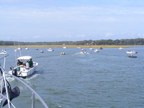
It didn't take long again to realize why we hadn't been that way in a few years. Boating traffic was heavy, cruisers and weekend locals. You had to worry about being waked and always watching for small boats zipping back and forth, weaving between other traffic. The ICW channel near Lockwood's Folly inlet and Shallotte's inlet, NC was jammed with fishing boats, netters and pole fishers, trying to catch a species of fish that was running heavy with the tide. We had to pick our way through the mess, and it was dangerous.
We heard the southbound T & B that had run aground at Carolina Beach inlet call the Coast Guard to tell them that a northbound vessel had told him that the channel was blocked by the fishing boats at both of the locations, and he wanted the CG to clear the channel before he got there. The CG seemed to be hesitating, so we got on the radio and said it was really true and that we had had a difficult time getting through the crowd, with FLUKE only being 18' wide. The T & B was 250' long and 56' wide,and he was fully loaded to 17' high. We could hear him issuing a security warning announcing the areas he was approaching and that vessels needed to clear the areas. When he was 5 minutes from Lockwood's Folly he announced he was approaching and a nervy fisherman got on the radio and said “What is your authority?” The tug captain gave him the specifications of his rig and added that he had limited maneuverability. Since we didn't hear any maydays we assumed the CG had managed to clear the channel.
Bridges are a real problem because most of them have timed openings, some just once/hour. If you miss the opening you have to wait in traffic, wind, and the current. Maneuverability is limited in the tight quarters, and it's stressful having to drift for so long. Timing your approach to reaching the bridge is complicated by shallow water, traffic, and currents as you pass the inlets. Fortunately high rise bridges have been built to eliminate some of the old ones that require waterway openings. However, this dreadful little relic of a pontoon bridge still exists at Sunset Beach, NC. It only opens on the hour. That is assuming, they can get it open. If the tide is too low, the bridge can't be pulled over to the side to let the boats through. The picture shows our sister ship, ALLEGRIA, passing through. What looks like a pile of junk on the right hand side of the picture is really the bridge.
We were trying to reach another bridge that only opened on the hour, and it was going to be borderline. We had the engine revved up the highest we had ever had it. 5 go fast boats needed to pass us, and they were worried about getting to the bridge too. We decided to tell them to pass on plane, without us or them having to slow down at all. We figured we would let our stabilizers “save” us from rolling and we would carefully turn into their wakes, reducing the roll. 4 of them passed with minimal roll. The 5th one slowed down a bit and then sped up as he was right beside us, creating a huge gaping hole in the water right next to us. We crashed down into it, just like a gigantic ocean wave. FLUKE rolled violently as we all held on tightly, and we could hear things crashing down below. Eddie's TV had flown off the desk top and slid on the floor. Somehow it still worked. We managed to make the bridge, but the 2 sailboats trailing behind weren't close enough, and even though they begged the bridge tender to leave it open longer he wouldn't. They would have to wait another hour.
ALLIGRIA was leading the way when we came up to the Barefoot Landing swing bridge. Greg called the bridge tender on the radio to find out what his opening requirements were (he was on demand) and also what the water clearance was under the bridge and that both of us would need to get through. The tender told him that the depth was 31.5', and Greg said he needed 31' to get under. The tender said “You should try it” and Greg said “That's cutting it a bit close, and I could damage some equipment if I touch”. The tender said “This is a busy bridge. If I have to open it it will hold up a lot of traffic, so you should try it” I got on the radio and said “We are the second boat, and we need 34', so you're going to have to open it anyway”. Then Greg said “I guess that settles it”. Then the tender wanted our boat names and hailing ports, so we are probably being added to some new government dissenters list.
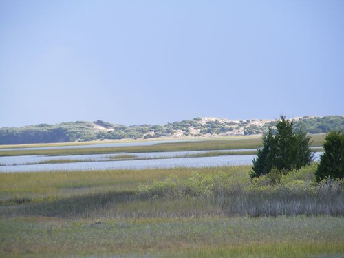
The coastal ICW is not all terror and no pleasure. Some of the scenery is just beautiful. The coastal dunes and vegetation are fascinating, and I never tire of looking at them no matter how miserable or frustrated I get with the waterway traffic. You can see the ocean and hear the roar of the waves in several places. Looking across the open golden marsh areas and tidal creeks is a pretty sight.
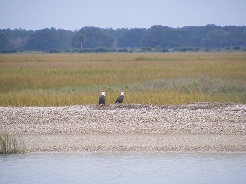
It is important to look high and low, in the water and on the land because you never know when nature will treat you to a special surprise. We have seen so many golden eagles and bald eagles on this trip, usually flying or perched in trees, so seeing this pair on the ground was interesting.
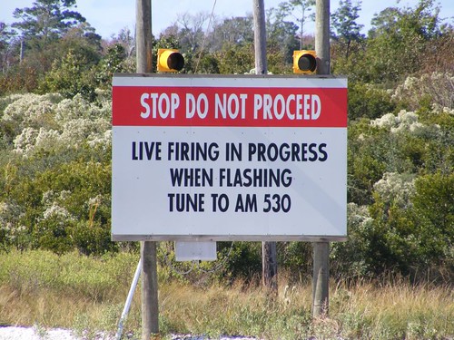
It is a surprise to see the Camp LeJeune firing range sign for the first time and think what an odd contrast to the peacefulness and splendor of nature all around it. We were lucky that no live firing exercises were in progress and we didn't get held up for that too.
You can easily see several of the practice targets that get fired at. They are old pieces of equipment riddled with dents and bullet holes, sitting out in an open area.
I enjoy looking at the waterfront homes and developments. We all have different tastes here in the U.S., and that is apparent in the variety of our homes. There is something to suit everyone's tastes, but all the homes along the waterfront in these areas command a high price tag. We have seen residential docks running out to the deeper water that are over ¼ mile long. Everyone takes a picture of this bright house, no matter if they like it or not since it sits all by itself and is so glaringly obvious.
In previous postings I've included some photos of yard art that I've found interesting for one reason or another. I would like to know the significance of putting a creature like this in the backyard of your expensive waterfront home since we're not in Africa or close to any zoo.
This fanciful aquatic creature is more my idea of keeping within the boundaries of the seaside art category.
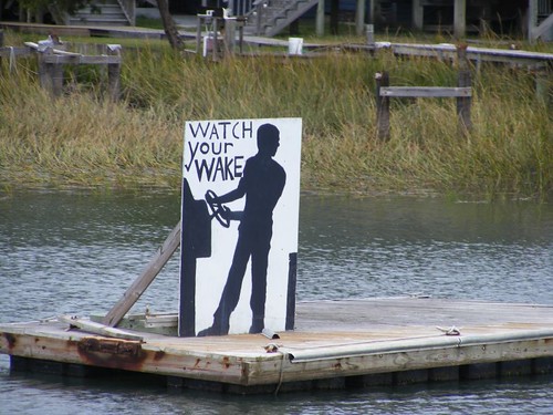
Dealing with passing wakes is very frustrating for waterfront residents who want to try to keep a boat docked along the busy ICW and not have it get beat to pieces by some of the tidal wakes. One resident “hired” this gentleman to try to help solve the problem.
When we got close to the Myrtle Beach, SC area there were no anchorages that we could feel comfortable with to drop the hook, so we decided to go to Barefoot Landing Marina. It is part of a big outlet mall type complex with lots of places to shop, eat, and be entertained. Since we arrived late in the day there wasn't time for shopping. Eddie decided to treat the crew to a delicious pizza called the Big Kahuna from California Ultimate Pizza. While we were waiting for our take out pizza we stopped in at Bullys Bar and sucked down a cold draft beer. It hit the spot after having to listen to that bridge tender. We further eased our pains of a hectic day by visiting Maggie Moos for ice cream treats. Wayne and I had something called Chocolate Extreme that was even extreme by my standards. I never thought I could say that about any ice cream concoction, but this thing actually had too many M & Ms in it to go with the chocolate sprinkles, chunks of brownies, and fudge that were mixed in with the dark chocolate ice cream. Eddie had something that had a couple of kinds of nuts in it, and he said there were too many of those too. We recommend that you visit Maggie Moos and make your own rating.
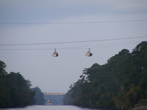
Myrtle Beach waterfront has lots of houses, condos, bars, marinas, and golf courses, plenty to gawk at as you go by. One golf facility has its parking lot on one side of the ICW, and the golf course on the other side. You take an overhead tram high over the waterway so you can tee off.
In previous postings of our other adventures through the Carolinas I described the fascinating parts of the waterway in more detail regarding the communities along the way. There is so much to see if you are lucky enough to be traveling at a leisurely pace like we do aboard FLUKE. Hilton Head and Beaufort,SC areas provide a lot of rubber necking opportunities. No stopping for us this time, though.
Despite several days of cloudy and misty weather, we continue to have a super time, just like this boat we passed south of Beaufort, SC.
We're hoping to try to get out in the ocean to avoid the shallows of the Georgia ICW and the same perils that we faced in the Carolinas.
Subscribe to:
Post Comments (Atom)







Yikes! Too much adventure. I hope the rest of the trip is uneventful and downright boring!
ReplyDeleteAs always, great pictures! The ICW is probably more scenic despite all the problems. Glad Fluke wasn't damaged...have a safe trip back home.
ReplyDeleteBob and Dorinda
Danielle says the Magical Mist picture looks like a fantasy. Awesome! Was the Milky Way out on that dark night? Great sunrise too.
ReplyDeleteWally