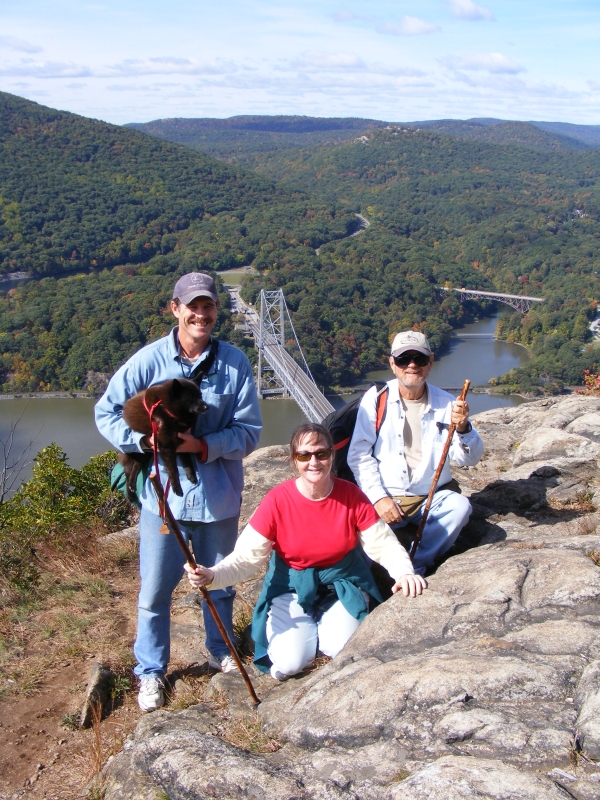
We're On Top of the Nose!
October 7-8, 2009
The water in the anchorage area at the base of Bear Mountain where we wanted to drop the hook was calmer, but the wind was still really howling when it gusted down between the mountains. The next day was supposed to be clear and nice, so we decided to anchor south of the dock for the night and stay with our plan to hike up to the top of Anthony's Nose the next morning if the winds calmed enough to where we felt safe to leave FLUKE unattended.
We had gotten anchored in the afternoon which would give us plenty of time to see how well we were going to hold before it got too dark to move somewhere else if we started dragging anchor. We clocked gusts as high as 40.6 KTS, but our 88# Delta and 200' of chain kept us in place. We saw a steady stream of cruising boats heading south. Imagine our surprise when we looked up to see this freighter loaded up with all the Dutch canal boats that we had seen when we went through Albany. In the background is Anthony's Nose.
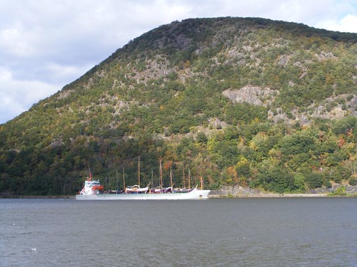
Goodbye Dutch Beauties
There was a lot of water slapping the hull when the tide changed and the wind and the tide were going against each other. Fortunately we weren't anchored farther out toward the river where the current was even swifter. Still, it was so noisy I decided to sleep in the pilothouse where I would just hear the wind. Plus, if we started to drag anchor during the night I would be able to quickly start the engine and yell for the guys to come up to help.
When we awoke the following morning the winds had died down and the sky was so clear. The high temperature was only going to be around 65°, so it would be perfect for hiking up the mountain. We had even come up with a new plan to get to the Bear Mountain Bridge without having to break the park rules again by taking Ursa through the no dogs allowed area. Wayne thought we could just walk along the railroad tracks until we got to the base of the bridge and then climb up the side of the mountain until we intersected the park trail leading over to Fort Montgomery that we had used on our previous expedition.
We packed a picnic lunch, launched the dinghy without mishap, and docked at the floating dock next to the big fixed dock where people were fishing and crabbing. This time we even remembered to bring the lock to lock the cable from the dinghy to the dock!
We found a path through the brush that took us over to the tracks. It was easiest to walk right down the middle of the tracks since we could stand on the ties or the flatter big rocks in between. No trains came in either direction. When we reached the base of the bridge we could see a faint path leading up the mountain, so we tried that and meant with success in intercepting the Fort Montgomery trail. We back tracked on it up to the sidewalks on the bridge.
You don't walk very far until you see this sign. It is a really LONG way down to the water, and it is closer to the parking lot..
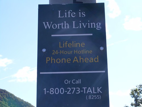
If You Need a Friendly Ear
It is also a LONG way over the bridge and is a cool, breezy walk, especially when it is early and the sun isn't shining enough to warm things up yet. The bridge intersects Anthony's Nose on the east side of the river and is visible in this photo.
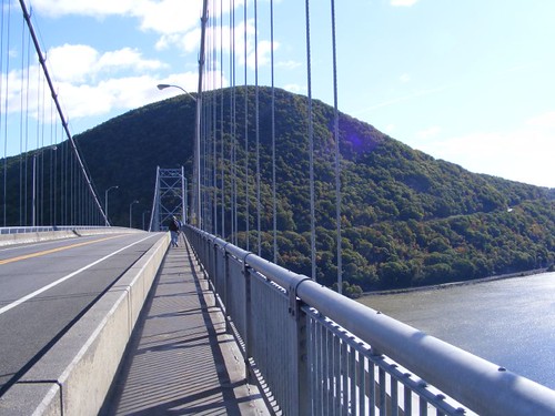
High Walkers
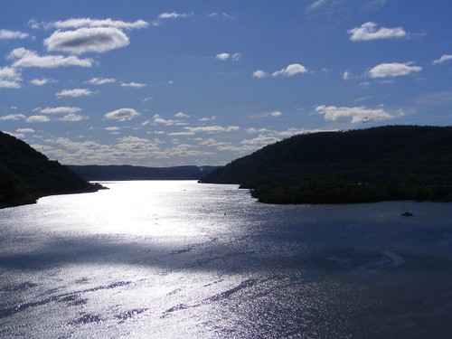
The views from the bridge were so interesting in the early morning light as it was rising up on the sides of the mountains and reflecting off the water. This photo exposure makes for an interesting effect off the water, almost looking like it could even be ice as the Hudson River flows south. FLUKE is at anchor on the right side, all alone.
What Time Is It
We saw several vessels of varying types and sizes pass beneath the bridge, but this one caught our attention. We don't get to see the tugs and barges from this angle.
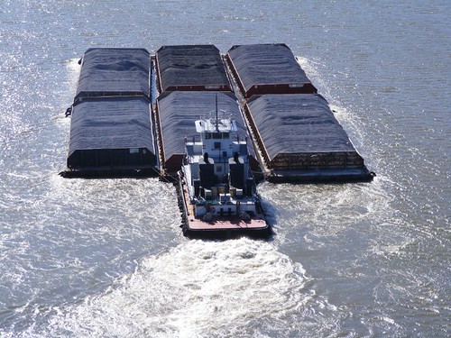
A Big Six Pack
When we finished crossing the bridge we were faced with two obstacles. The first was to try to figure out which way, north or south, the Appalachian Trail went once it left the bridge since we knew that the AT eventually intersected the trail we would need to take to get to the tip of Anthony's Nose. We would later see, on the return trip, where the trail marks for the AT were painted on the side of the mountain directly in front of the bridge, but were obscured by a patch of weeds. Once we guessed that we should go north, we had to figure out how to cross the highway to get from the south side of the bridge without getting run over. There are no crossing aids, and it is a weird intersection with one side being the rock of the mountain with no room to stand; you just have to wait and make a run for it.
The Appalachian Trail shared highway 9D for about a quarter of a mile before it began its way again up the side of the mountain, and the trail head was easy to find. We sure were surprised to see how steep the trail was to begin with. We had to climb for about 1.5 hrs mostly straight up the side of the mountain until we reached the intercepting trail. There were so many acorns on the ground in some places it was like walking on marbles, and you had to be really careful not to slip. Sometimes the rocks were just like stairs, but at least they were solid. The trail was clearly marked and well used, so there was no fear of getting lost. I must say it was quite a strain for Eddie and I compared to our hiking days of years past when we were much younger and more agile.
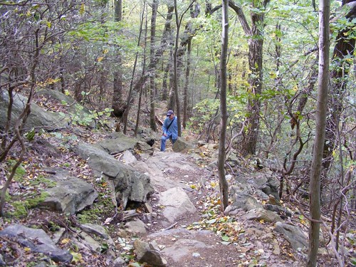
Rocky Stairs
We had relief when we reached the trail to Anthony's Nose. It runs along the top of the mountain, mostly flat with only a few ups and downs. It was so beautiful walking amongst the trees with their falling leaves, wide open areas, large boulders, and cool temperatures. There was even a small pond in one area, nestled in the trees.
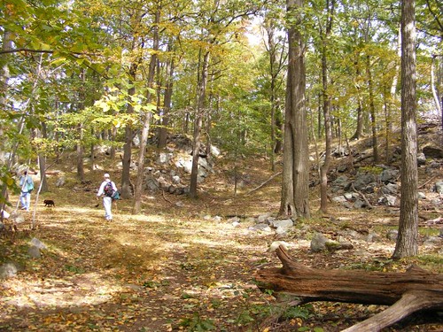
The Relief Trail
The high winds from the previous day had blown a lot of leaves , sticks, and branches off the trees and even blew over some dead trees. We were able to pass through all the debris easily. This tree caught our attention.
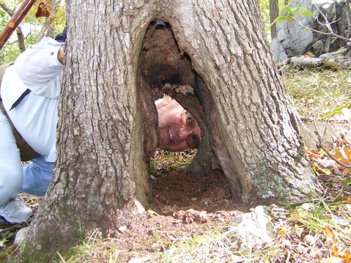
Checking To See If It Is Male or Female!
When we reached the end of the trail and were all the way out on the Nose's point we were not disappointed with the effort it had taken to get there. The view is breathtaking, from looking far in the distance over the other Appalachian Mountains, all the way down to the river and bridge below, and to the long vista to the south as the river winds its way through the other mountains. FLUKE looked like a little dot from our 950' perch.
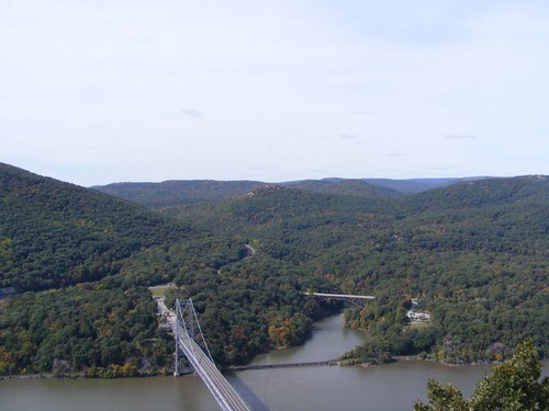
The Mountain Vista
This photo shows the west side of the bridge where our morning walk began way down below and many of the mountains in the distance. Bear Mountain State Park is to the left. We were told by some other hikers you can see the buildings of Manhattan from the top of Bear Mountain. That hike is on our list for the future, whether we arrive by boat or car.
Wayne used the video feature on our new camera to take a short panoramic video standing on the peak and scanning from the south until the view is blocked by vegetation to the north. Clicking on the image will play the video for you. Enjoy!
On Top Of Anthony's Nose
We found a sunny spot out of the wind to have our picnic lunch. We didn't have to have much conversation because it was thrilling sitting out on the very tip of the peak watching the world go by all around us. Plus, we were really hungry from the appetites we had worked up. I wish I could say we were dining with eagles, but we had to settle for the vultures, now at eye level, which were gliding effortlessly by us on the winds coming off the side of the mountain, a stone's throw from where we were sitting. We heard only the wind and the rustle of leaves.
During our ascent we saw a couple of side trails that warranted checking out. I thought this little trail was fascinating because it was so neatly lined with a thick moss border. You can see a lot of acorns on this trail, but they didn't pose any hazard since the trail was so flat.
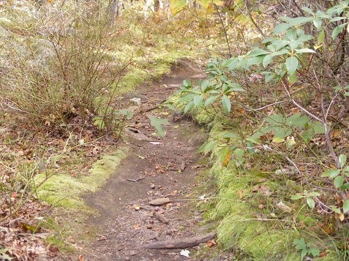
The Fairy Highway
Another side trail took us to a spectacular overlook that gave us a northern view up the Hudson River. We could see West Point (in the upper left), and several of the other mountains we had passed.
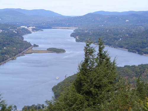
The Northern Vista
Gravity was our friend as we wound our way back down the mountain to the highway. Back across the bridge, down the mountain to the railroad tracks and back to the dock. The dinghy was still safely locked up and hadn't been molested and we made it safely back to FLUKE who had been in our sight most of the day, although from quite afar.
It was a grand day to remember with a sense of accomplishment and wonder. Plus, I carried two pieces of quartz in my pocket, souvenirs that I picked from the tip of Anthony's Nose, which I called the two boogers!


That's quite the travel documentary. Maybe these towns could grant you some of their stimulus money as a consideration for the promotional exposure...
ReplyDeleteOk, you're spoiling us now!
ReplyDeleteGreat pictures and a panoramic video!
Now that we've seen what you can do, your greedy audience (me) is going to be expecting this from now on...
Thanks so much - it's almost like I was there!
Jerry
We agree with Jerry!
ReplyDeleteBob and Dorinda