I have put a placemark at each place we stopped on our way from Vero Beach, FL to Oswego, NY, a distance of 1544 miles.
Click on the link below the map for larger view where it is easier to pan and zoom. You can also click on any of the placemarks for more details.
Wednesday, September 30, 2009
Saturday, September 26, 2009
CRUISING INTO FALL
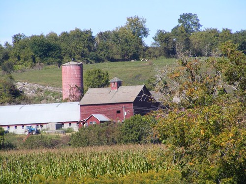
Canalside Dairy Farm
September 25, 2009
Posting from Waterford, NY
I hope you didn't think that just because we reached Lake Ontario our adventures were over, and you wouldn't be hearing from us again. Our return trip would include some other stops, and we would be able to see things we missed on the first pass by. We spent 19 days cruising from Waterford to Oswego, and it took us 5 days to travel back again from Oswego to Waterford. It would have taken us a lot longer if Wayne hadn't been paying attention when I was at the helm and came up to the Three Rivers intersection. I just kept going straight from the Oswego Canal into the Seneca River instead of turning east into the Erie Canal. Duh! Most other cruisers have commented that the 5 days was too long, and look at us in disbelief when we tell them about the 19 days. We think they just missed a lot by not stopping and exploring the canalside towns and historic sights. It has been so much fun waking up in the morning and saying when do we want to stop today?, even if it is just a few miles away. It's like being a kid during summer vacation!
Summer Vacation Canal Fun
September 18 was Wayne's birthday, and we celebrated with a cake. The FLUKE crew can never have too much cake! Wayne is making a double batch of English muffins as I write this, but he didn't have to bake his own cake.
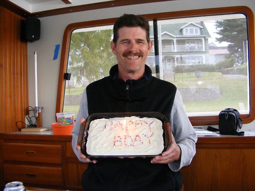
The Birthday Boy
Speaking of important dates, September 20 was National Pirates Day. We passed through Sylvan Beach and saw this pontoon boat with the crew all dressed up in pirate garb. We hooted and hollered at them and they yelled “Argh, Argh” back at us. Notice their pirate ship mast with “sails” attached is toppled over onto the pontoon boat roof. It was a cardboard tube and got bent from the wind. At least they had the spirit even though they weren't riding on the Black Pearl!
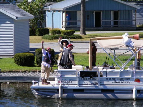
Canal Pirates
We saw a wind farm (we could count at least 30 windmills) on the high hills surrounding Oneida Lake that we had been unable to see during our first pass through. We had a conversation about all the clean energy sources we have seen on this trip, especially all the little hydroplants associated with the locks. We have discussed getting solar panels and a wind generator for FLUKE to help make us more energy efficient.
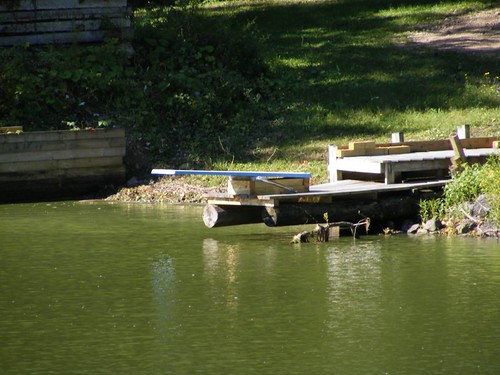
We can't complain about the weather either. There have been a few cloudy days, and one morning it was 33° when we took Ursa for her walk. A couple of travel mornings we had to deal with some thick fog that settled in after we had left the dock, and we were thankful there weren't other boats nearby before the fog lifted. We were only able to creep along at idle speed, 3 knots.
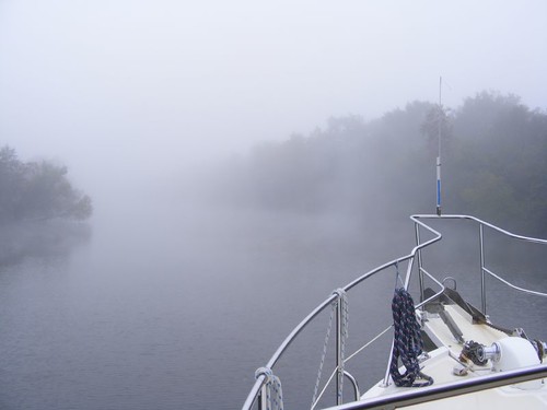
Poor Visibility
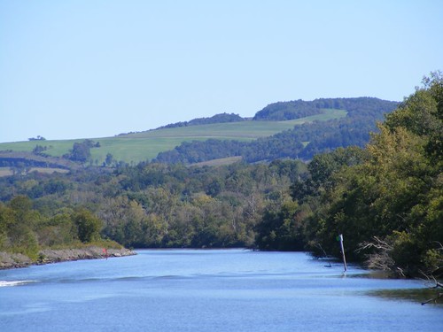
Most of the days have been beautiful, and you can never tire of looking at the water or surrounding hills. September 22 was the first day of Fall, and the leaves have started to change color on some of the trees. There is even a pile of colorful leaves on the dock I walk through to get back up to land. The fields of corn are being harvested, and we are seeing pumpkins and mums on doorsteps. We even have our own mum on a table in the cockpit: Eddie bought a pretty golden one with a gazillion blossoms.
Rolling Hills
We've furthered our enjoyment of learning about the lock system, talking with the lock attendants, and experiencing the locking through process. I learned that Lock O-7, at Oswego, placed third in the statewide lock competition based on how well the lock and its property is kept in order. I thought it would have been nice to have a visible sign posted, and I wondered if we had used the first and second place finishing locks too. The Lock 7 attendant (Joe) also told me that since there were budget cutbacks annual flowers were no longer supplied for landscaping, and it was up to the lock attendant to do whatever they wanted, if anything. So, Joe filled all the planters with vegetables, and gives them out to people who want them.
The Lock 23 attendant handed us a cucumber off the fence as we were locking through. He told us that he has the busiest lock, and on July 4 he had 90 openings.
We followed a small, trailerable boat into one lock. They tried to hold their boat in place with their boat hook hooked onto the safety ladder that hangs vertically the whole height of the lock. The woman holding the hook dropped it, and the boat shot all the way to the other side of the lock and had to have the bow fended off to minimize smashing it into the wall. They managed to get back to the other side again and grab hold of the boat hook. Someone blurted out on the radio “First timers”. I looked at the lock attendant, who was shaking his head and laughing, and I said “that boat looks like a ping pong ball”.
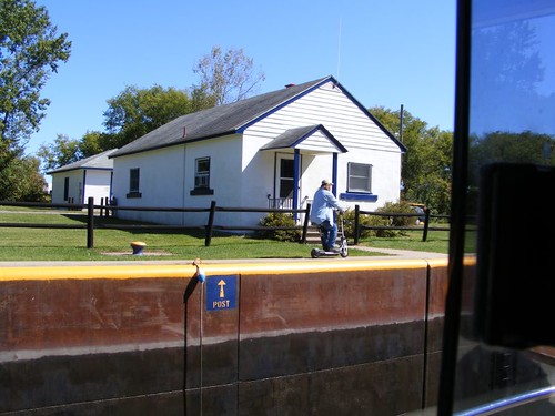
Scooter Man
This was the strangest sight we've seen locking through. The locks are 300' in length. The lock operator has to open the lock on the end you are entering, and then he has to go to the other end where you will exit to open the other gate when the lock is done emptying or filling. This guy used the scooter to go back and forth. Notice he is not wearing a Personal Floatation Device (PFD). The lock cap walkway he is scooting on is not very wide. None of the attendants wear PFDs, and I have wondered what would happen if one of them fell in while a boat was locking through. It is difficult to hold a big boat like FLUKE in place when a deep lock is filling, and it would be a challenge to try to help someone who fell in the lock.
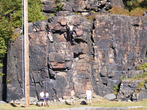
Climbers By Lock 17
We wanted to stop at Lock 17 (the deepest one, 40') again and tie up on the east wall, below the lock like we did on the westbound leg of our trip so that we could hike on Moss Island one more time. We had a big surprise when we exited the lock and saw two construction barges tied up in “our” spot. We crept over to have a look see and decided, with some effort, we could squeeze between the two of them. We needed the practice in tight docking maneuvering anyway.
A Rose Between Two Thorns
The most interesting new stop we made on the return trip was Yankee Hill (so-called by the locals and the facility signage), but known as Putnam Park in the cruising guide. It's seemingly small dock keeps people away, but we gave it a good test and can report it is worth the stop.
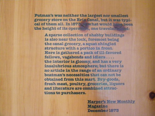
Historical Summary
The property was once the site of the Putnam store, which has been recreated using some of the original lumber. Inside the building you can find great historical photos of canal store scenes and information about what life was like at these stops. There are even restrooms in the building. Someone has painted a life-like mural of the shelved goods behind a counter.
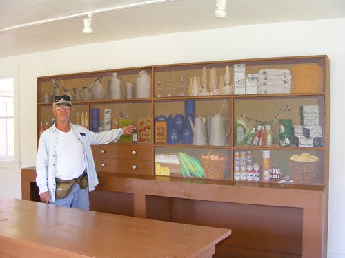
Eddie Tries To Make A Sale
The grounds have picnic tables, grills, and wide open spaces adjacent to the best preserved double lock from the improved phase of the Erie Canal we saw on the whole trip with informational plaques. The double locks were designed to be able to lock through barges that were going east and west at the same time so that neither barge direction had to wait for the other. The demand for quicker time was higher for eastbound barges because they were fully loaded with goods from the Lakes regions, so the locks were doubled in length in the eastbound direction to be able to take two barges at the same time.
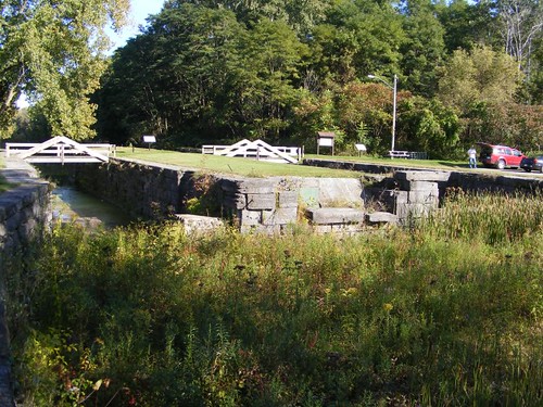
Two Is Better Than One
There are bike and walking paths that go through Yankee Hill, and you can walk all the way over to the Schoharie Crossing sight, about 2.5 miles, right along the old canal tow road. However, be careful, while the abandoned canal has been filled with rubble and debris there are still many places where water is held in place for a long time, and it functions as a prime breeding site for mosquitoes. It may be cooler in the shade of the trees along the tow road, but watch out for those voracious insects!
I managed to get a nice picture of a preserved portion of one of the original aqueducts used to carry the barges over the Mohawk River. Just look at the beautiful stone work. Wayne read where the pressure exerted by the weight of the water being carried over the aqueduct actually strengthened the blocks in the arch underneath.
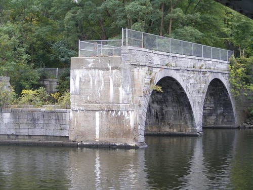
Aqueduct
We sure had a surprise when we pulled into Waterford again after our month's absence. The canal police had come through a couple of weeks earlier and gave out $100 tickets to any boat who had been here more than 48 hours, based on a NYS statute that says you can't tie up to a canal wall longer than that time. Remember when we were here a month ago, the Visitor's Center said the first 2 days were free, and then it was $10/day after that, which we gladly paid for our 9 day stay here. Word has it that other canal communities and private marinas are complaining that the cruisers all want to stop at Waterford and not stop at the other places. Well, duh, Waterford has so much to offer and goes out of their way to make it boater friendly. People gladly shop at the local stores and eat at the restaurants. Plus, the docks are right in town where it is convenient, safe, and fun to walk around. So, the canal police posted signs saying the stay is limited to 48 hours, and the Visitor's Center can't charge people. So, they have set up a donation jar where you can put in your money, and they don't make you put the date down when you arrived at the dock now, so the canal police will have a difficult time figuring out when anyone pulled in since they don't just hang out watching. We haven't seen one since we've been here, and no one has seen them since they gave out the tickets the last time. Our plan is to stay here as long as we want and see what happens. Our rap sheet may continue to grow!
Wednesday, September 23, 2009
Waterford Visitor Center Web Cam
Sep 23, 2009
We are back at Waterford Harbor 4 weeks after leaving. This is just a quick post to show you where FLUKE is on the web cam. A full post will follow before too long.
You might even see Eddie washing the boat (or BS'ing with people walking by).
FLUKE at Waterford Harbor Visitor Center
We are back at Waterford Harbor 4 weeks after leaving. This is just a quick post to show you where FLUKE is on the web cam. A full post will follow before too long.
You might even see Eddie washing the boat (or BS'ing with people walking by).
FLUKE at Waterford Harbor Visitor Center
Friday, September 18, 2009
THE END AND THE BEGINNING
Glad To Be Here
While we were all reluctant to leave Phoenix, we were also anxious to get to Oswego, where we would get to see Lake Ontario; none of us has seen any of the Great Lakes. There is really so much to see in this grand country of ours!
Well, we didn't have a good send-off from Phoenix. We planned an early start and got up on time, despite some fog. We had decided to pump out the holding tank (time for me to make myself scarce), and moved FLUKE over next to the pump out without incident. We all had our doubts about how effective the pump-out machine was going to be, but Eddie said he had tried out the sucking mechanism using a bucket of water, and the pump had sucked it dry. I commented that that wasn't a fair test since the pump would have to suck a long way up out of our holding tank. Plus, the end of the suction hose had been taped and rigged. All pump out holes aren't the same diameter, so you never know what to expect.
The pump worked itself steadily, but there were too many air leaks at the tip of the hose, so we couldn't maintain a good enough suction to empty the tank. I think we tried for over an hour. Since it's free we can't complain much. At least we hadn't reached “critical mass” in the tank, and we can make it back to Waterford where we had success the first time. Plus it is cool enough now such that the ports are closed and the sewer gases aren't asphyxiating us. I haven't even heard Eddie whining about it.
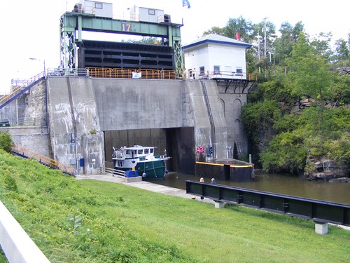
The Oswego Canal locks presented a couple of different issues to deal with. They all don't have the convenient ropes to hold off to, and instead you have to run one of your own lines around a fixed vertical cable set within the lock wall. We used these in the first lock at Troy, but we were going up which meant that the cable was right next to us when we pulled into the lock. In these Oswego locks, we are going down. We have to reach from the upper midships deck with the boathook extended way out and push the line through and pull it all the way back up. I push it through and Eddie grabs it with his boat hook, lifting it off my hook. One of the lock attendants even asked if we wanted him to loop the line through when he saw how far we were from it. He was impressed when he saw how we worked out the problem. Those guys are so nice!
Bridge Over Troubled Waters
The other thing that takes some getting used to are these fixed bridges that cross right over the top of the lock. When we pull up, FLUKE is higher than the bridge. However, we get lowered down 20' so then we can safely pass under the bridge. When you are locking up you have to make sure no part of your boat is under the bridge where it could get crushed on the way up.
It is a pretty river trip from Phoenix to Oswego. There are a lot of waterfowl, higher end modern homes, rural landscapes, and lots of foliage. I laughed when I saw this flock of plastic flamingos out of place on the shoreline. Maybe we should give them a ride back to Florida where they would be more at home.

Birds Out Of Place
My first impression of Oswego didn't get off to a good start. How things changed, and I ended up being sad to leave.
After we exited Lock 7 we needed to decide where to tie up to the canal wall in the half mile space before reaching Lock 8. At least we had already decided we weren't going to go through Lock 8 and stick our bow out in Lake Ontario (hopefully we will have a trip in the future where we will get to travel a lot out on the lake), but there was much discussion about exactly where to tie up along the wall.
I don't like to be where there is a lot of noise, and when we exited Lock 7 I immediately saw 3 bridges looming overhead within the next half mile. Bridges usually mean noise. I suggested we tie off on the newly done wall with a nice railing, good cleats, and a park-like mowed grassy area close to Lock 7. Wayne said he wanted to get a closer look at the area by Lock 8, so we continued to move forward.
That area had a beat up wall, just rings embedded in the wall, instead of cleats, to tie off to, and some other undesirable features like a huge (handicap accessible) porta potty (they always stink), and 4 homeless looking vagrants sitting under one of the picnic pavilions. I told Wayne and Eddie I liked the looks of the area by Lock 7 better, but if they wanted to be right next to the outhouse and get friendly with the vagrants I could probably adjust. We ended up by Lock 7.
Vagrant-free Zone
The following morning a police officer showed up and chased all the vagrants away; we never saw them again. I asked the officer if we and FLUKE were going to be “safe” docked where we were, and he said they had not had any trouble in the area where we were.
If you look in the photo pictured above you will see that we are docked across from a spill over. That's because the water in the foreground is the Oswego River, and the water we are on is the Oswego Canal which is 10' higher than the river. The spillover is designed to let the water that comes out of Lock 7 have a place to go when Lock 8 hasn't opened. All the locks have a bit of a flow coming out of them anyway even when they are closed. You can even see Lock 7 in the background if you look closely enough.
Two of the bridges I mentioned earlier carry road vehicles, but they have sides on them that dampen the noise. The other bridge was an old railroad bridge that has been converted into a very nice pedestrian walk over, linking the areas on the east and west side of the waterways. Both sides of the waterways have beautiful riverwalk areas that extend for over a mile and get a lot of use from walkers and fishermen.
Since the Oswego River flows into Lake Ontario salmon leave the lake to begin their migration up the river for spawning in the Fall. The migration had just begun, and we got to see some interesting fish action. I saw a big salmon jump high out of the water 3 times with a lamprey eel attached to its side. One of the fishermen hooked a salmon with an eel on it, and the hook fell out of the salmon and hooked the eel. The salmon can only go as far as the first dam they encounter which is connected to a power plant adjacent to Lock 7. Many people wade out into the water and fish right at the base of the dam. We ran into these guys early one morning as they were headed back to their cars.
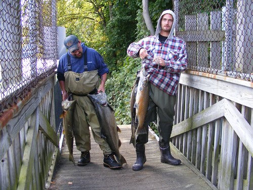
Salmon Buffet
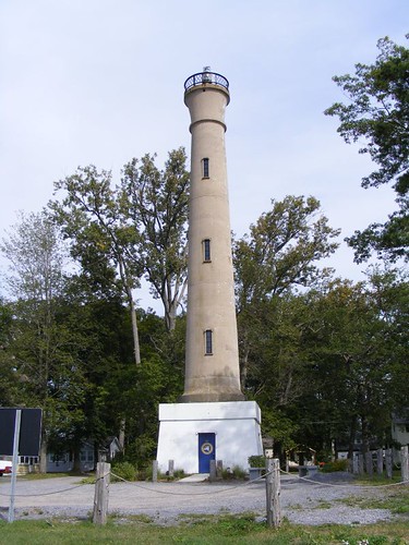
It is a nice walk all the way to Lake Ontario which looked like the ocean on a couple of days when the wind was really blowing. There is a gigantic breakwater designed to protect the inner harbor and mouth of the river. The picturesque West Pierhead Lighthouse marks the end of one of the sides.
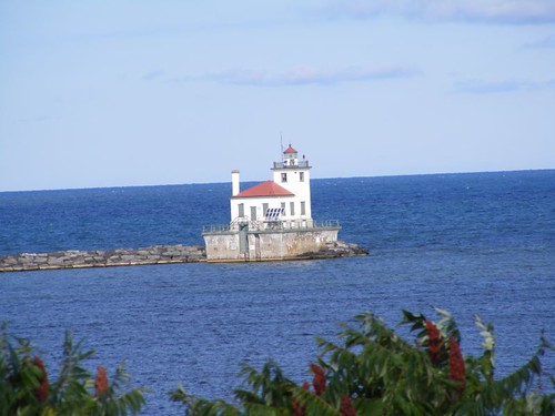
West Pierhead Lighthouse
The east side of the waterway has undergone a lot of urban renewal so there area lot of new buildings, residential and commercial, right along the waterway. The commercial port activities take up space on both sides on the northern most end, closest to the lake Several murals have been painted around town depicting some important events in Oswego history, each in an appropriate location. This one is down on the waterfront.
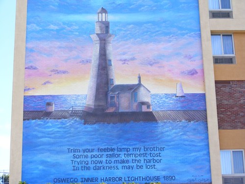
The Guiding Light
Fort Ontario is one of the important historical sights within walking distance. The British built a wooden fort on the present day site in 1755, but that fort was destroyed by the French. The British rebuilt the fort out of earth and timber, but it was destroyed in 1778 by the American Revolutionary troops that came over from our previous tour site, Fort Stanwix (where Wayne and Eddie received their cannon firing training!). The fort continued to change hands between the two sides until it finally wound up in American hands after the war ended. The earth and timber structure was further fortified with the stone mined from the lake shore and still stands today. Fort Ontario even had some use in modern times when it served as an emergency refugee center for victims of the Nazi Holocaust in 1944-46, the only one of its kind in the U.S.
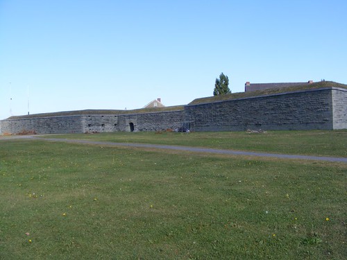
Fort Ontario
We had gone to the fort on Tuesday morning, only to find it locked up tight, and there were no signs indicating any operating hours. A grumpy old man walking around the outside grounds said he thought the fort closed after Labor Day. So, we were disappointed and decided to walk the perimeter of the fort. It is located on a high bluff overlooking Lake Ontario, so the view is captivating. We also decided to walk down to the shore of Lake Ontario.
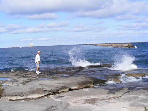
Eddie Checks Out The Rocky Shoreline
Since we already have “criminal” records and experience in B & E, I suggested we just break into the fort (there were a couple of places in the outer wall that we could have easily scaled) and look around on our own, but Wayne didn't think it was a good idea. Eddie and I would get into a lot of trouble if Wayne wasn't around to keep us in check. We just happened to be at the entrance to the fort when the door opened and a park employee stepped out. He said that cutbacks had necessitated that the fort be closed on Mondays and Tuesdays after Labor Day. I told him that we had come by boat all the way from Florida to see the fort, but he didn't buy that. We told him we would be back on Wednesday.
You have to take a self-guided walking tour of the fort. I hope during the “season” they have people present, like at Fort Stanwix, to answer questions because you can sure come up with a lot of questions that aren't answered on the walking tour guide map. There was one volunteer present, but he only had a limited scope of knowledge. However, it is nice to be able to go at your own pace. They are even dog friendly, so Ursa was with us. The fort is restored to its 1868-1872 appearance. The buildings are partially furnished and give you a good feel for life at the fort during that time period when it was garrisoned by the Veteran Reserve Corps, who were wounded or disabled Civil War veterans. It is well worth the time to visit.
It is easy to see how important the land around Fort Ontario was and why it was strategically important from a military perspective and how it played an important role in the development of the Port of Oswego.
Oswego started out as an important trading post. It was situated at the crossroads of Lake Ontario which led into the far northern reaches of Canada and the Oswego River which eventually led into the Hudson River and on to the Atlantic Ocean The Indians first frequented the area, followed by the early white tradesmen, then the permanent settlers, and numbers of different government troops. Water was always the key link to the port and continued on to modern times when sailing vessels packed into the port, followed by steamers, and then the railroad. Mills and industries of all kinds sprang up, using power from the river to drive the factory turbines. Oswego became a major railroad hub, linking New York and Ontario to the western railroads.
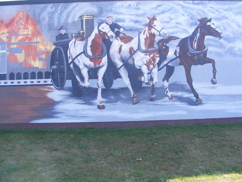
Early Firefighting Mural
Today Oswego has about 20,000 inhabitants; the largest town we have visited There are no longer any operating mills, and port activites are limited. The original downtown still has some of the old mill buildings, converted into various small business uses like we have seen at all the other towns. Some of the larger buildings, with their unique architectural details house present day government enterprises. There are many historic churches and well-kept period homes from the mid to late 1800s. You can't beat the weekly Farmers Market held throughout the summer months. One whole block of main street downtown is blocked off from 5-9 every Thursday for vendors to sell fresh produce, baked goods, locally grown wines, and other cottage industry products. There is something for everyone.
Here is a map that shows how far we got before it was time to turn around.
Sunday, September 13, 2009
NOT ARIZONA
September 13, 2009
After leaving Sylvan Beach, we had an easy cruise across 20 mile long Lake Oneida. It felt good to be out in the open waters again. The lake is well marked, and has plenty of depth. It is easy to navigate around all the lake fishermen. Fishing must be good judging by how many people were out fishing, despite being quite windy!
Brewerton is located right on the western shore of Lake Oneida, and we were stopping there to pick up parts for the auto pilot, or so we thought. Upon contacting Brewerton Boat Yard, who is supposedly a dealer for the parts we needed, we found out they couldn't get the parts. We had "ordered" them 2 weeks earlier, but the guy never bothered to tell us he couldn't get the parts.
We tied up on the western most wall of the canal, beyond both of the noisy bridges. We had been there for about half an hour when a state trooper pulled up in the parking lot nearby. He walked over to the canal wall, past FLUKE so he could see her stern, and then wrote something down on a pad of paper he was carrying. We assumed it was our name. There is a sign saying that you can't stay there more than 48 hrs. in one month (I can't imagine why anyone would even want to!), but that didn't seem like it would be a rule enforced by the state police. I was wondering if they had finally managed to track us down for our unlawful entry into Bear Mountain State Park!
The local canal cruise boat, the Mystere, uses the same terminal wall for its operation. Eddie went over to talk to the friendly captain and crew of the boat after they had let off their afternoon passengers and asked where we could buy some fresh produce. They said that there really weren't any places close by, but we could have all of their leftover food from the cruise: sandwich rolls, salad fixings, and half a lemon bundt cake. That was the best part of our stay in Brewerton. The captain did say that there had been some break ins on his cruise boat, and maybe that was why the state trooper had shown up.
Brewerton prospered as a boat building town in the early 1900s after the Erie Canal had been rerouted along its waterfront during the third phase construction. We walked around the area close to the waterfront, and it isn't very scenic, doesn't have any interesting buildings, and no shopping of any significance. Everyone was happy to leave after just one night.
The Erie Canal follows the path of the picturesque Oneida River once it leaves Brewerton. It is not just a straight ditch, but rather gently winds along going past small settlements and rural homesites.
Choices
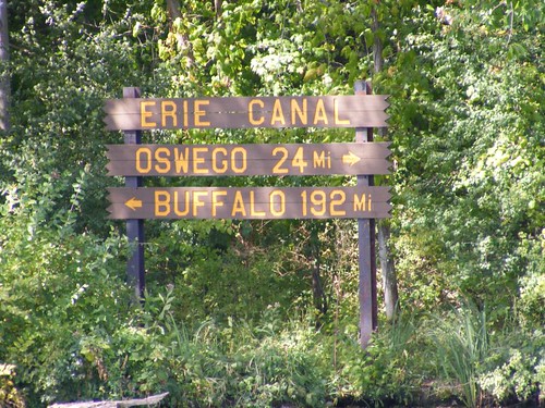
Mile 160 of the Erie Canal is at Three Rivers, the junction of the Oneida River, Seneca River (leads to the Finger Lakes) and the Oswego River, forming the beginning of the Oswego Canal, our next destination. This natural junction has played an important role in history as a meeting place for Indians and then troops during the French and Indian and Revolutionary Wars.
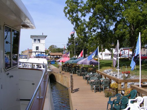
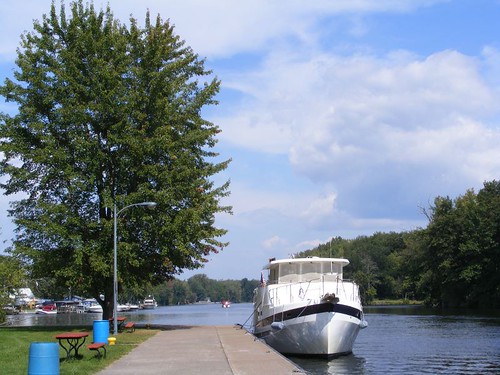
In just 3 miles we wound up in Phoenix, one of the friendliest canal towns we have visited. We are docked at Henley Park, located right next to Lock 1 of the Oswego Canal. The area dedicated for the canal right of way is quite large, and the small community has done a top notch job of making it civilian and boater friendly for docking, fishing, and just hanging out. They want to encourage boaters using the Oswego Canal to stop and spend some time infusing money into their struggling economy.
Tied Up
Lock 1 is unusual in that it is right in the town, not on the outskirts like all the other terminal wall areas we have used for docking. The town has fixed up the area with colorful landscaping, picnic tables, covered pavilions, and fishing platforms. There are free 15 Amp electrical hookups and water connections. The Bridge House Brats is a local organization for young kids (preteen) that cater to the boaters by carrying breakfast orders from the local waterfront restaurants, helping with errands and boat chores, and keeping the park clean and orderly.
The dock area stayed full, and many boats locked through while we were tied up. We were docked next to Ladyhawke, a Krogen 42. Like all Krogenites, it was easy to get to know her owners, Lynn and Dick and share our boating experiences and talk about the other Krogenites. We all ended up going to the local Masons weekly fish fry, just a few blocks up the hill from the canal. We pigged out on the greasy, but good, fried fish, clams, shrimp, and fries and topped that off with a nice, high calorie homemade dessert.
The park is the local gathering place for many of its friendly citizens and town functions. They meet for coffee in the morning and are happy to answer boater's questions and try to solve the world's problems. On September 11 the town held a candlelight vigil in remembrance of the Twin Towers tragedy. It was a moving experience to see the huge turnout of citizens and the presence of the fire, police, scout, and veteran groups. There were speeches, a 21 gun salute, youngsters read poems, a flag ceremony, a bugle reverie with taps, and patriotic songs. We were proud to be there with the locals and to be reminded how important it is not to forget that fateful day that so drastically changed our lives forever.
Phoenix Town History
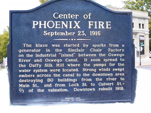
We think it is interesting that a town named Phoenix actually burned to the ground. Since most of the town was rebuilt after the big fire of 1916, the homes don't date back to the 1800s like we have seen in a lot of the other canal towns. In general, the town has a much better up kept look to it in the residential areas; although we think some of the sidewalks must have survived the fire and must be a a lot older than the present homes judging by how bumpy some of them are. There appears to be a real sense of neighbor and community as evidenced by how many people use the waterfront and the large groups of kids and adults we see congregated in their yards and on their porches. Even crime has a community feel to it as evidenced by these signs that are posted on the windows of many storefronts. We all stayed on our best behavior!
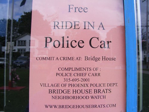
When Free Isn't Good
From here we have 7 locks to go through, from our present elevation of 363' down to 245' where we will be at the level of Lake Ontario, all in the span of about 20 miles. If we can get started early enough tomorrow we might make it in one day. The locks close at 5:00 now that it's past Labor Day. Eddie has expressed concern that we want to make sure we aren't here, upriver, when they start permanently closing the locks for the winter!
The ice cream truck is passing by playing “It's A Small World After All”, pretty appropriate for our journey and all the wonderful people we are meeting.
After leaving Sylvan Beach, we had an easy cruise across 20 mile long Lake Oneida. It felt good to be out in the open waters again. The lake is well marked, and has plenty of depth. It is easy to navigate around all the lake fishermen. Fishing must be good judging by how many people were out fishing, despite being quite windy!
Brewerton is located right on the western shore of Lake Oneida, and we were stopping there to pick up parts for the auto pilot, or so we thought. Upon contacting Brewerton Boat Yard, who is supposedly a dealer for the parts we needed, we found out they couldn't get the parts. We had "ordered" them 2 weeks earlier, but the guy never bothered to tell us he couldn't get the parts.
We tied up on the western most wall of the canal, beyond both of the noisy bridges. We had been there for about half an hour when a state trooper pulled up in the parking lot nearby. He walked over to the canal wall, past FLUKE so he could see her stern, and then wrote something down on a pad of paper he was carrying. We assumed it was our name. There is a sign saying that you can't stay there more than 48 hrs. in one month (I can't imagine why anyone would even want to!), but that didn't seem like it would be a rule enforced by the state police. I was wondering if they had finally managed to track us down for our unlawful entry into Bear Mountain State Park!
The local canal cruise boat, the Mystere, uses the same terminal wall for its operation. Eddie went over to talk to the friendly captain and crew of the boat after they had let off their afternoon passengers and asked where we could buy some fresh produce. They said that there really weren't any places close by, but we could have all of their leftover food from the cruise: sandwich rolls, salad fixings, and half a lemon bundt cake. That was the best part of our stay in Brewerton. The captain did say that there had been some break ins on his cruise boat, and maybe that was why the state trooper had shown up.
Brewerton prospered as a boat building town in the early 1900s after the Erie Canal had been rerouted along its waterfront during the third phase construction. We walked around the area close to the waterfront, and it isn't very scenic, doesn't have any interesting buildings, and no shopping of any significance. Everyone was happy to leave after just one night.
The Erie Canal follows the path of the picturesque Oneida River once it leaves Brewerton. It is not just a straight ditch, but rather gently winds along going past small settlements and rural homesites.
Choices
Mile 160 of the Erie Canal is at Three Rivers, the junction of the Oneida River, Seneca River (leads to the Finger Lakes) and the Oswego River, forming the beginning of the Oswego Canal, our next destination. This natural junction has played an important role in history as a meeting place for Indians and then troops during the French and Indian and Revolutionary Wars.
In just 3 miles we wound up in Phoenix, one of the friendliest canal towns we have visited. We are docked at Henley Park, located right next to Lock 1 of the Oswego Canal. The area dedicated for the canal right of way is quite large, and the small community has done a top notch job of making it civilian and boater friendly for docking, fishing, and just hanging out. They want to encourage boaters using the Oswego Canal to stop and spend some time infusing money into their struggling economy.
Tied Up
Lock 1 is unusual in that it is right in the town, not on the outskirts like all the other terminal wall areas we have used for docking. The town has fixed up the area with colorful landscaping, picnic tables, covered pavilions, and fishing platforms. There are free 15 Amp electrical hookups and water connections. The Bridge House Brats is a local organization for young kids (preteen) that cater to the boaters by carrying breakfast orders from the local waterfront restaurants, helping with errands and boat chores, and keeping the park clean and orderly.
The dock area stayed full, and many boats locked through while we were tied up. We were docked next to Ladyhawke, a Krogen 42. Like all Krogenites, it was easy to get to know her owners, Lynn and Dick and share our boating experiences and talk about the other Krogenites. We all ended up going to the local Masons weekly fish fry, just a few blocks up the hill from the canal. We pigged out on the greasy, but good, fried fish, clams, shrimp, and fries and topped that off with a nice, high calorie homemade dessert.
The park is the local gathering place for many of its friendly citizens and town functions. They meet for coffee in the morning and are happy to answer boater's questions and try to solve the world's problems. On September 11 the town held a candlelight vigil in remembrance of the Twin Towers tragedy. It was a moving experience to see the huge turnout of citizens and the presence of the fire, police, scout, and veteran groups. There were speeches, a 21 gun salute, youngsters read poems, a flag ceremony, a bugle reverie with taps, and patriotic songs. We were proud to be there with the locals and to be reminded how important it is not to forget that fateful day that so drastically changed our lives forever.
Phoenix Town History
We think it is interesting that a town named Phoenix actually burned to the ground. Since most of the town was rebuilt after the big fire of 1916, the homes don't date back to the 1800s like we have seen in a lot of the other canal towns. In general, the town has a much better up kept look to it in the residential areas; although we think some of the sidewalks must have survived the fire and must be a a lot older than the present homes judging by how bumpy some of them are. There appears to be a real sense of neighbor and community as evidenced by how many people use the waterfront and the large groups of kids and adults we see congregated in their yards and on their porches. Even crime has a community feel to it as evidenced by these signs that are posted on the windows of many storefronts. We all stayed on our best behavior!
When Free Isn't Good
From here we have 7 locks to go through, from our present elevation of 363' down to 245' where we will be at the level of Lake Ontario, all in the span of about 20 miles. If we can get started early enough tomorrow we might make it in one day. The locks close at 5:00 now that it's past Labor Day. Eddie has expressed concern that we want to make sure we aren't here, upriver, when they start permanently closing the locks for the winter!
The ice cream truck is passing by playing “It's A Small World After All”, pretty appropriate for our journey and all the wonderful people we are meeting.
Thursday, September 10, 2009
BACK TO THE BEACH
September 10, 2009
We've Got Our Ducks All In A Row
After leaving Rome we locked down the next two locks, 50' total. It sure is a lot easier going down: less turbulence, not getting pushed into the side wall, and just a gentle lowering. We have seen an increase in cruising traffic, mostly boats flying Canadian flags. They say they are headed south, eventually to Florida or the Bahamas. Several have said they plan to stop in Annapolis, MD for the boat show which takes place the first week of October. They are all surprised when they find out we are headed north. We saw this small cruise ship which was headed north to pick up passengers to go on a leaf peeping cruise. We've seen the ship in Florida on the ICW in years past.
Looking For Passengers
We stopped at Sylvan Beach, located on the shore of Oneida Lake. They have several hundred feet of canal wall space available for docking, free with a 48 hr. limit. We heard that on the Labor Day weekend boats were rafted up to four deep along the wall, so we had stayed an extra day in Rome to make sure the holiday traffic cleared out, and there was plenty of space available for us.
Still Pointed North
The atmosphere at Sylvan Beach is quite a change from all the other stops we had made along the canal. It is strictly a summer resort and vacation town. There are no old mill buildings or grand period homes of architectural uniqueness, since the first two phases of the canal didn't pass through here. Most of the residential homes are very small, stacked closely together with minimal yard space, and some were already boarded up for the winter. The majority of the commercial buildings are restaurants or bars with a couple of small gift shops. A lot of those establishments are closed or have reduced their hours of operation since Labor Day. The one thing that makes Sylvan Beach unique is that it has an old timey amusement park, complete with one of those rickety roller coasters.
Sylvan Beach Waterfront
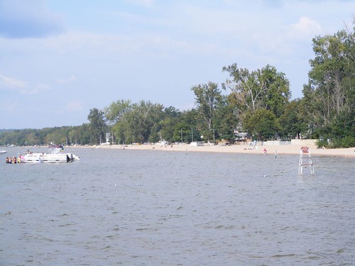
The main draw for Sylvan Beach is 20 mile long Oneida Lake and its sandy shore line. Apparently the fishing is good out on the lake, and the waters are friendly for all kinds of boating and swimming activities. One of the marinas near where we are docked has 200 slips, and there are several other marinas in the area. I saw a large, waterfront boating information sign that talked about boating on the lake and used the terms courtesy zone and common sense zone. I had to laugh as I never thought those were words that most day boaters would even understand when it came to using their boats. Maybe boating on a lake is a different pastime than what we've seen on our travels in the coastal waters.
Oneida Lake's size forced the original Erie Canal to have to be routed many miles to the south and be routed through Syracuse. Since the barges didn't have any self-propulsion they couldn't make it across the lake, and the lake was too wide and deep to try to build up dikes for the mules who pulled the barges to be able to walk on. It wasn't until boats became steam powered that Oneida Lake became part of the modern day canal system.
Verona Beach Lighthouse
We walked over the bridge to Verona Beach. Even though it is right next door to Sylvan Beach it has a much less festive atmosphere. A lot of the homes are full time residences and are on larger pieces of property. Interestingly, the Verona Beach Lighthouse sits on a small plot of land right in the middle of a residential neighborhood. At least they have left an access road so people can visit it, but there are signs posted limiting your stay to 1 hour to prevent people from making it a recreational facility. The 84.5' tall lighthouse was built in 1915 as part of the modern phase of the Erie Canal to guide boats, coming from the opposite shore, into Wood Creek where we are docked. Beautiful Verona Beach State Park is a short distance away where people can camp and swim.
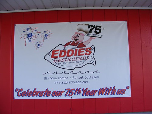
Guess Where We Ate
We ate out for the first time since we were in the Bahamas. This place, now in their 75th year of business, gives heaping portions of all their food, including the desserts. We gorged on BBQ pork sandwiches and old fashioned greasy fries. I think FLUKE sat a bit lower in the water after we boarded again that evening!
Time to move on. Here is a map of FLUKE at Sylvan Beach.
We've Got Our Ducks All In A Row
After leaving Rome we locked down the next two locks, 50' total. It sure is a lot easier going down: less turbulence, not getting pushed into the side wall, and just a gentle lowering. We have seen an increase in cruising traffic, mostly boats flying Canadian flags. They say they are headed south, eventually to Florida or the Bahamas. Several have said they plan to stop in Annapolis, MD for the boat show which takes place the first week of October. They are all surprised when they find out we are headed north. We saw this small cruise ship which was headed north to pick up passengers to go on a leaf peeping cruise. We've seen the ship in Florida on the ICW in years past.
Looking For Passengers
We stopped at Sylvan Beach, located on the shore of Oneida Lake. They have several hundred feet of canal wall space available for docking, free with a 48 hr. limit. We heard that on the Labor Day weekend boats were rafted up to four deep along the wall, so we had stayed an extra day in Rome to make sure the holiday traffic cleared out, and there was plenty of space available for us.
Still Pointed North
The atmosphere at Sylvan Beach is quite a change from all the other stops we had made along the canal. It is strictly a summer resort and vacation town. There are no old mill buildings or grand period homes of architectural uniqueness, since the first two phases of the canal didn't pass through here. Most of the residential homes are very small, stacked closely together with minimal yard space, and some were already boarded up for the winter. The majority of the commercial buildings are restaurants or bars with a couple of small gift shops. A lot of those establishments are closed or have reduced their hours of operation since Labor Day. The one thing that makes Sylvan Beach unique is that it has an old timey amusement park, complete with one of those rickety roller coasters.
Sylvan Beach Waterfront
The main draw for Sylvan Beach is 20 mile long Oneida Lake and its sandy shore line. Apparently the fishing is good out on the lake, and the waters are friendly for all kinds of boating and swimming activities. One of the marinas near where we are docked has 200 slips, and there are several other marinas in the area. I saw a large, waterfront boating information sign that talked about boating on the lake and used the terms courtesy zone and common sense zone. I had to laugh as I never thought those were words that most day boaters would even understand when it came to using their boats. Maybe boating on a lake is a different pastime than what we've seen on our travels in the coastal waters.
Oneida Lake's size forced the original Erie Canal to have to be routed many miles to the south and be routed through Syracuse. Since the barges didn't have any self-propulsion they couldn't make it across the lake, and the lake was too wide and deep to try to build up dikes for the mules who pulled the barges to be able to walk on. It wasn't until boats became steam powered that Oneida Lake became part of the modern day canal system.
Verona Beach Lighthouse
We walked over the bridge to Verona Beach. Even though it is right next door to Sylvan Beach it has a much less festive atmosphere. A lot of the homes are full time residences and are on larger pieces of property. Interestingly, the Verona Beach Lighthouse sits on a small plot of land right in the middle of a residential neighborhood. At least they have left an access road so people can visit it, but there are signs posted limiting your stay to 1 hour to prevent people from making it a recreational facility. The 84.5' tall lighthouse was built in 1915 as part of the modern phase of the Erie Canal to guide boats, coming from the opposite shore, into Wood Creek where we are docked. Beautiful Verona Beach State Park is a short distance away where people can camp and swim.
Guess Where We Ate
We ate out for the first time since we were in the Bahamas. This place, now in their 75th year of business, gives heaping portions of all their food, including the desserts. We gorged on BBQ pork sandwiches and old fashioned greasy fries. I think FLUKE sat a bit lower in the water after we boarded again that evening!
Time to move on. Here is a map of FLUKE at Sylvan Beach.
Monday, September 07, 2009
ALL ROADS (AND RIVERS) LEAD TO ROME
September 7, 2009
On Sept. 4, we left the dock at Herkimer after the fog lifted. It appeared we were going to be traveling in a part of the canal that was more ditch-like than river-like, with the NY Thruway noise close by, two negatives on my list. Plus, there was a lot of floating debris, sticks, logs, branches, another negative on my list. It was the first time we had seen much debris on the Erie Canal, and it was unusual since we hadn't had any rainy weather to wash stuff from the inflowing streams.
A work dredge, who was notified by one of the lock attendants that we were headed in his direction, contacted us to tell us that we needed to hold back until he could move out of the way. As we got close, he called us and said we were much bigger than he realized and that since he could only move so far, we would have to slowly inch our way as close as we could get to him to get by his work area. He put a man out on his side closest to us to direct us over as near as we could get; Eddie was outside and could have shaken hands with the guy on the barge. At least they were all friendly, and they even asked questions about FLUKE as we were inching by.
Lock 20 was noteworthy for two reasons. The walls are in quite a state of disrepair, and pieces (like cement and small rocks) of the sides crumbled off when we touched them to fend off and fell down on the boat. Lock 20 is the last lock that will take us farther up; we are now at 420'. As we continue westward we will go through locks that will be lowering us.
The city of Rome, where we ended up, is located in what was a position of important geological prominence since humans have been tromping through this area. It is at the juncture of where the Mohawk River began its easterly flow all the way to the Hudson River (and then the Atlantic Ocean) and Wood Creek began its westerly flow to Lake Ontario.
The old canal terminal wall where we are docked is part of the area known as the Oneida Carrying Place. The name comes from the Oneida Indians who inhabited this prime trading area and the fact that travelers portaged their vessels six miles from one river to the other right by here. It represented an important link to connect Lake Ontario to the Atlantic Ocean.
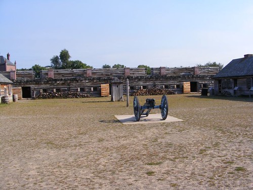
Fort Stanwix
The British recognized the importance of the area and built Fort Stanwix in 1758 to help them fight the French and Indian War. After the British won the war, the fort was abandoned in 1763. In 1776 Gen. Geo. Washington was ordered to rebuild the fort to serve as a foothold for future westward expansion. In August of 1777, British troops and their Indian allies laid siege to the fort for almost the whole month. The British troops outnumbered the Continental soldiers 2 to 1, but were unable to penetrate the well-built fort. The siege was ended when Maj. Gen. Benedict Arnold arrived to reinforce the fort's garrison.
After the war ended, peace was made with the local Indians, and the Oneida Carrying Place opened up again. Fort Stanwix was no longer needed to defend the area and was let go into disrepair. Eventually the land upon which it sat was built upon as part of the city of Rome's burgeoning growth. In July 1817 the construction of the original Erie Canal began not far from where Fort Stanwix once stood.
In 1976 the city of Rome partnered with the National Park Service to rebuild a replica of Fort Stanwix using many of the original plans and documents. First, they had to purchase all the properties existing where the fort once stood, encompassing several modern day city blocks, 16 acres in all. Somehow they managed to sell the local citizens on the benefits the project had to offer and successfully launched the project. After razing the site, archeological digs were conducted to collect artifacts from what was the original Fort Stanwix foundation. Then the "new" fort was built almost as a faithful replica of the original, probably being the largest wooden fort in American today. The fort isn't just represented by the wooden buildings and four bastions themselves; it also includes the acres of ditches, berms, and surrounding bare areas (glacis) that were instrumental to protecting the structure itself. Photos at the fort show the before and after shots, and really give you a feeling of how unique the new Fort Stanwix is, an oasis sitting right in amongst the modern city buildings and streets.
The inside of the fort gives you a feel for what life must have been like for the 800 soldiers housed within its walls: OK for a visit, but not the kind of place you'd like to spend even one night at. You can see officers' quarters, the sally port, barracks, dining areas, powder room, and various bastions. All the areas have some interiors set up depicting what the insides would have been like.
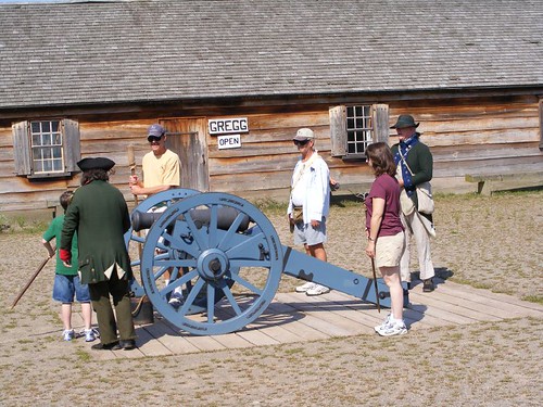
Training The Recruits
The morning we were there, was one of the days they had artillery demonstrations. There are volunteers, dressed in period costumes, who answer questions, give tours, and lead in demonstrations. The "artillery commander" said he needed 6 volunteers to fire one of the cannons; Eddie and Wayne volunteered. Wayne's job was to swab out the cannon to make sure no residue was left from previous firings that would interfere with a new firing and ramming in the charge and ball. Eddie's job was to hold his finger over the vent hole so the cannon didn't lose prime and also to fill the hole with the gun powder that would blow the cannonball out of the cannon. Having just toured the Remington Arms factory, they were psyched!
The artillery commander took each of the six recruits through their job specs. Then he wanted them to work as a team and go through the jobs without his assistance to see if they could get the cannon to fire correctly. So, they started to try to do it, but then I began asking questions. The artillery commander would answer my questions and not pay attention to his recruits. Wayne and Eddie yelled over at me to shut up while they were trying to do their "jobs". Hey, the commander didn't say no one could ask questions, and I had some good ones: what did they do about the recoil from the cannon and didn't the cannon get hot enough to burn the finger of the man plugging the vent hole? Plus, I really think the commander liked answering my questions.
Wayne and Eddie received honorable discharges from the Continental Army, and we could get on with our boating lives. We have spent a lot of time walking around the areas near the waterfront. We are close to what was originally settled as the Little Italy section of Rome; even today most of the storefronts in the area have Italian names. Modern shops are conveniently located within a reasonable walking distance; by our definition that is 2 miles or less. We walked over to the Friday night Cruise In, where locals bring their restored and souped up cars for people to ogle over and ask questions about. They even had a local DJ from the "Oldies" station doing a live radio show and giving out door prizes. Eddie went back in time to the 50s when he did the same thing to his cars. I was thankful he didn't have any cigarettes to roll up in his sleeve, and he doesn't have enough hair left to wear it in a pompadour.
Since it has been the Labor Day holiday weekend we have just stayed put. We were concerned we may not find as suitable a place with people being off for the long weekend. FLUKE is the biggest boat we have seen since we have been this far west, and docks for her size are limited. However, tomorrow we continue onward.
On Sept. 4, we left the dock at Herkimer after the fog lifted. It appeared we were going to be traveling in a part of the canal that was more ditch-like than river-like, with the NY Thruway noise close by, two negatives on my list. Plus, there was a lot of floating debris, sticks, logs, branches, another negative on my list. It was the first time we had seen much debris on the Erie Canal, and it was unusual since we hadn't had any rainy weather to wash stuff from the inflowing streams.
A work dredge, who was notified by one of the lock attendants that we were headed in his direction, contacted us to tell us that we needed to hold back until he could move out of the way. As we got close, he called us and said we were much bigger than he realized and that since he could only move so far, we would have to slowly inch our way as close as we could get to him to get by his work area. He put a man out on his side closest to us to direct us over as near as we could get; Eddie was outside and could have shaken hands with the guy on the barge. At least they were all friendly, and they even asked questions about FLUKE as we were inching by.
Lock 20 was noteworthy for two reasons. The walls are in quite a state of disrepair, and pieces (like cement and small rocks) of the sides crumbled off when we touched them to fend off and fell down on the boat. Lock 20 is the last lock that will take us farther up; we are now at 420'. As we continue westward we will go through locks that will be lowering us.
The city of Rome, where we ended up, is located in what was a position of important geological prominence since humans have been tromping through this area. It is at the juncture of where the Mohawk River began its easterly flow all the way to the Hudson River (and then the Atlantic Ocean) and Wood Creek began its westerly flow to Lake Ontario.
The old canal terminal wall where we are docked is part of the area known as the Oneida Carrying Place. The name comes from the Oneida Indians who inhabited this prime trading area and the fact that travelers portaged their vessels six miles from one river to the other right by here. It represented an important link to connect Lake Ontario to the Atlantic Ocean.
Fort Stanwix
The British recognized the importance of the area and built Fort Stanwix in 1758 to help them fight the French and Indian War. After the British won the war, the fort was abandoned in 1763. In 1776 Gen. Geo. Washington was ordered to rebuild the fort to serve as a foothold for future westward expansion. In August of 1777, British troops and their Indian allies laid siege to the fort for almost the whole month. The British troops outnumbered the Continental soldiers 2 to 1, but were unable to penetrate the well-built fort. The siege was ended when Maj. Gen. Benedict Arnold arrived to reinforce the fort's garrison.
After the war ended, peace was made with the local Indians, and the Oneida Carrying Place opened up again. Fort Stanwix was no longer needed to defend the area and was let go into disrepair. Eventually the land upon which it sat was built upon as part of the city of Rome's burgeoning growth. In July 1817 the construction of the original Erie Canal began not far from where Fort Stanwix once stood.
In 1976 the city of Rome partnered with the National Park Service to rebuild a replica of Fort Stanwix using many of the original plans and documents. First, they had to purchase all the properties existing where the fort once stood, encompassing several modern day city blocks, 16 acres in all. Somehow they managed to sell the local citizens on the benefits the project had to offer and successfully launched the project. After razing the site, archeological digs were conducted to collect artifacts from what was the original Fort Stanwix foundation. Then the "new" fort was built almost as a faithful replica of the original, probably being the largest wooden fort in American today. The fort isn't just represented by the wooden buildings and four bastions themselves; it also includes the acres of ditches, berms, and surrounding bare areas (glacis) that were instrumental to protecting the structure itself. Photos at the fort show the before and after shots, and really give you a feeling of how unique the new Fort Stanwix is, an oasis sitting right in amongst the modern city buildings and streets.
The inside of the fort gives you a feel for what life must have been like for the 800 soldiers housed within its walls: OK for a visit, but not the kind of place you'd like to spend even one night at. You can see officers' quarters, the sally port, barracks, dining areas, powder room, and various bastions. All the areas have some interiors set up depicting what the insides would have been like.
Training The Recruits
The morning we were there, was one of the days they had artillery demonstrations. There are volunteers, dressed in period costumes, who answer questions, give tours, and lead in demonstrations. The "artillery commander" said he needed 6 volunteers to fire one of the cannons; Eddie and Wayne volunteered. Wayne's job was to swab out the cannon to make sure no residue was left from previous firings that would interfere with a new firing and ramming in the charge and ball. Eddie's job was to hold his finger over the vent hole so the cannon didn't lose prime and also to fill the hole with the gun powder that would blow the cannonball out of the cannon. Having just toured the Remington Arms factory, they were psyched!
The artillery commander took each of the six recruits through their job specs. Then he wanted them to work as a team and go through the jobs without his assistance to see if they could get the cannon to fire correctly. So, they started to try to do it, but then I began asking questions. The artillery commander would answer my questions and not pay attention to his recruits. Wayne and Eddie yelled over at me to shut up while they were trying to do their "jobs". Hey, the commander didn't say no one could ask questions, and I had some good ones: what did they do about the recoil from the cannon and didn't the cannon get hot enough to burn the finger of the man plugging the vent hole? Plus, I really think the commander liked answering my questions.
Wayne and Eddie received honorable discharges from the Continental Army, and we could get on with our boating lives. We have spent a lot of time walking around the areas near the waterfront. We are close to what was originally settled as the Little Italy section of Rome; even today most of the storefronts in the area have Italian names. Modern shops are conveniently located within a reasonable walking distance; by our definition that is 2 miles or less. We walked over to the Friday night Cruise In, where locals bring their restored and souped up cars for people to ogle over and ask questions about. They even had a local DJ from the "Oldies" station doing a live radio show and giving out door prizes. Eddie went back in time to the 50s when he did the same thing to his cars. I was thankful he didn't have any cigarettes to roll up in his sleeve, and he doesn't have enough hair left to wear it in a pompadour.
Since it has been the Labor Day holiday weekend we have just stayed put. We were concerned we may not find as suitable a place with people being off for the long weekend. FLUKE is the biggest boat we have seen since we have been this far west, and docks for her size are limited. However, tomorrow we continue onward.
Thursday, September 03, 2009
BIG AND LITTLE
September 3, 2009
After leaving Canajoharie we traveled 17.7 miles and tied up on the east side of Lock 17 along the lock wall. There was a lot to see and do in this area, and we picked an excellent spot to be able to watch activities at Lock 17 and access the town of Little Falls.
Exiting The Big One
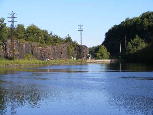
Lock 17 is unique to the NYS Canal system in that it has a vertical lift gate, one of two in North America; the other one being in Ottawa, Canada. Boats are raised or lowered 40', requiring 5 million gallons of water. When boats go under the gate, water drips on them (and line handlers standing outside!).
We have experienced some turbulence when locking through the bigger locks and wondered how we would do in Lock 17 when we had to go through it. I was talking to lock operator Scott, a congenial, chatty man, and he told me that deeper draft vessels should pull far forward and ask for a slow lift. That way the water flow coming in to fill the lock will be slowed down and not push us so hard into the wall, minimizing our fenders being crushed and not having to push to keep FLUKE off the lock wall. We followed his advice when we locked through, and we had less movement than when we had locked through the 30' high locks.
Locking Through On Foot
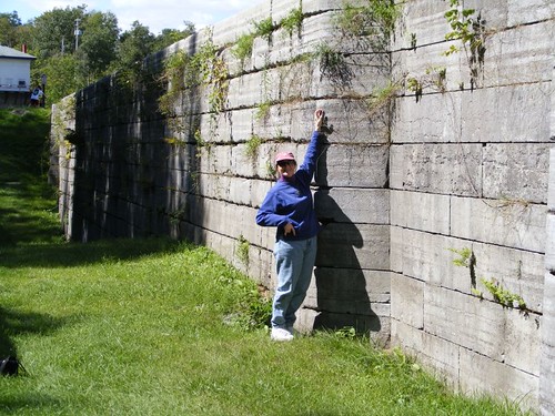
Like a lot of the present lock sites, Lock 17 is adjacent to one of the phase 2 Erie Canal abandoned locks, over 150 years old. I am standing right where one of the old gates would have been located, where the blocks have a rounded edge. Notice how tight the blocks fit together, with no mortar, and what great shape they are still in. The stone work is so perfect and uniform, all of that work done in a time when there weren't any power tools available.
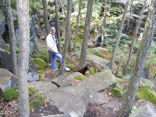
Moss Island Hikers
You can access Moss Island by crossing over the top of Lock 17. There are several informative displays which help explain some of the geological history of the area and why it is so unique. Moss Island, and the area on either side of the river in this area, is composed primarily of syenitic gneiss (pronounced nice) which are some of the oldest rocks in geological history and comprise the ancient roots of the Adirondack Mountains. The rocks are smooth to the touch, and Moss Island has trails that weave in, out, over, and around all sizes and shapes of boulders. Some jut right out over the river, providing spectacular views of the water below and adjacent mountains above. There are places where ancient water flows carved out circular tunnel shapes through the rock and look as though someone took a gigantic auger and drilled through the rock and then smoothed over the sides.
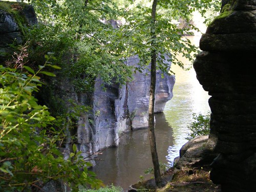
Water Carved Rock
On the outer boundaries of the island, where the rocks are not directly adjacent to the water, a large rock mass fronts the canal area with an adjacent land path. Rock climbers scale the boulders, some with all the rope gear, dangling themselves over the upper ledges. Other climbers scale the rocks with their bare hands. People gather just to watch the climbers, and so did we.
Where The Climbers Hang Out
The path visible in the above photo is on the north side of the canal and is an easy, picturesque, way to get into Little Falls. The electric poles in the photo are associated with the local power plant that utilizes the water from the canal and river to produce clean energy to power 8,000 homes. You have to walk over a grated area that is part of the power plant's intake area. It is safe and secure, but dogs hate to walk over the grates because their toes get caught. The power company made the walkway dog friendly by putting in rubber matting in a strip with a sign saying “Dog Path”.
Fishing At The Falls
Little Falls appears to be the most prosperous town we have visited so far on the Erie Canal. The area is the narrowest point in the Mohawk Valley, site of a natural deep gorge, just with tumbling cataracts, not waterfalls. It originally prospered as a mill town (there are no mills left) and a cheese producing area in the mid-1800s. One factoid stated that 380,000 lbs. of cheese were sold at the cheese market in a single day for “export” from the area.
A walk around town shows well kept period homes. The downtown area still has a lot of businesses in operation and has a small town feel to it, and it is possible to shop for small amounts of groceries, hardware, health and drug items, and there is even an operating motel and cinema. Canal Place is a site of a few boutiques, restaurants, and antique shops. Our favorite store turned out to be the Community Co-op which sells fresh produce, bulk spices, lots of organic foods, and similar specialty products.
A Canalway Trail, a paved path, is located on the south side of the lock area and canal, and you can access Little Falls by taking that as an alternate route. It was once the old railway route, and you walk through areas of the gneiss stone formation which had to be blasted out for the railroad, and you even go through a tunnel.. In the winter the trail is used for cross country skiing.
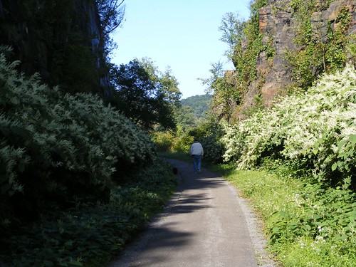
Canalway Trail
Taking the Canalway Trail 1 ½ miles east from Lock 17 will take you to the Herkimer House Historic Site. The 1764 home belonged to General Nicholas Herkimer who is credited with winning the Battle of Oriskany during the Revolutionary War. It is a pleasant walk to get to the site; you walk from high up on the side of the mountain to down right next to some swamp land. We passed over a flowing stream, and Eddie and I scampered down into the stream bed to look for Herkimer diamonds and interesting rocks. I found a big mammal bone of some kind. Hopefully it wasn't a human bone because I left it on one of the display plaques at the Herkimer House, and it may cause a real mystery. We don't need to have that added to our “rap” sheet for this voyage!
Herkimer House
Now that I've mentioned the Herkimer diamonds I need to explain what they are. Through millions of years of geological forces, water rich silica was turned into clear, hexagonal quartz crystals with points at both ends, which came to be called Herkimer diamonds. Local rock quarries mine an area that has several veins of the quartz running through them. The rock is used for fill, driveways, and construction projects, and it is common to find the quartz crystals embedded in the rock or “pure” by themselves, all of varying quality. A couple of the quarries allow visitors to try their hand at “prospecting” and dig for the diamonds. I would have loved to have spent some time doing that, but the mines were too far to walk and would have taken up too much time from our other activities. So, I put it on my “list” to try to buy a diamond along the way while we were in the area. That proved much more difficult than what I thought it would. I figured my best chance would be at our next stop, Herkimer.
Use The Woods Instead
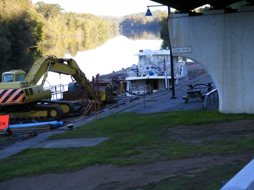
We only had to travel about 10 miles to dock where we would have good access to the town of Herkimer. This stretch of the canal is not very scenic, and it was the first time we have seen significant work being done on the canal itself. We always enjoy seeing the construction equipment, and all the NYS Canal equipment is painted their standard gold and blue and looks great.
Work In Progress
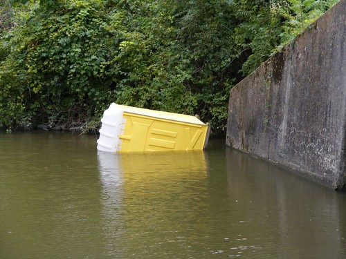
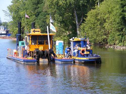
These workers were involved in part of a dredge operation. Notice the big arrow on top of the dredge directing river traffic to go left. The tugs we have seen range in size from little ones like this to ones 80' long. If you look closely you will see a porta potty between the tug and the crane barge. I found it amusing that the porta potty was actually on its own little floating platform and must just get pushed around like that to the different sites.
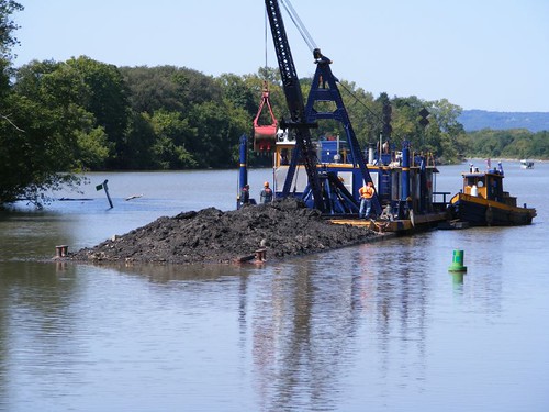
Floating Mud?
That mud isn't really floating; it is on a mud barge. When we approached, they had to move the barge out of the way for us to pass by, and they called us on the radio to ask us to stay back until they were able to move it far enough. The mud barge has large open “bins” that can be filled with the gunk and debris that gets scooped out of the river. When it is filled up, like you see in this photo, it gets moved to another location where it can be unloaded. The debris above the deck level can be picked off, but the material left down inside the bin, below deck level, can't easily be scooped out. So, they pump water into the bin and make a slurry out of the stuff and then suck it out and deposit it to a shore side location.
We went through Lock 18 and 5 miles later pulled up to a free dock at a place called Gems Along The Mohawk. Sounds like a place I should be able to get some of those diamonds, huh? We are now at an elevation of 383'. This place is right by Exit 30 of the NY Thruway, and the traffic noise is awful, the most of any stop we've made. Cruisers like to stop here because there are major shopping opportunities within reasonable walking distance.
Gems Along The Mohawk is a typical tour bus stop where you can get off the bus, have a meal at a place called the Waterfront Grill and then shop in the store for all kinds of souvenir items representing commerce from the area. They have some of the diamonds, but they are all in pure crystal form, ready to be made into jewelry, or already a jewelry piece, not what I had in mind. I really wanted to find one still embedded in the rock, which they had, but for display purposes. Oh, you can also take an Erie Canal tour here on a pontoon boat; you get a canal history and go through a lock, probably worthwhile.
Since we were going to check out the town anyway, I thought I might find some at a shop in town. I asked at a couple of places, but most people just go to the mine to get them directly and don't resell them. I figured my best bet might be a junk or resale shop, where you can find anything.
I spotted a shop called Cosmic and asked a couple of people waiting for a bus what it was. They said it was a head shop, but thought they might have some crystals too since some people think crystals and drugs go together.
Eddie and I checked out the place, and a nice woman, our age, was running it for her son. She had some of the crystals, but they were for display. Eddie's mind wandered back in time as he looked at all the new versions of drug paraphernalia, jewelry, and clothing. He ended up buying a peace symbol necklace, bracelet, and earring. Isn't it nice to know I could borrow his stuff if I needed it for that special outing?
Still searching for the diamonds, I walked into a junk store and told the guy what I wanted. Even though he didn't have any in the store, his mother was running their “branch” store a couple of blocks over, and she had some there. He would call ahead and let her know we were coming.
Well, she had a lot of the diamonds, piles of them, all of varying degrees of clarity and purity. We spoke at length of how they were acquired, and I found a small one attached to a tiny piece of rock that I figured was going to be the best that could come to my specifications. She was a wheeler dealer and showed me a pure diamond that she called a twin, which were two small perfect crystals joined together. They were very pretty, and she said I could have them for $10. While I agreed they were nice, I really wanted the one with the dirty rock attached, so she said I could have it for $5, and we struck a deal.
We weren't done with her though, because I had to show her my gem. I went outside and brought in Ursa. I already had found out she was a dog lover (she had pugs), so I knew she would get a kick out of Ursa. I put Ursa through her trick routines, and the woman loved it. She said she liked me so much, she wanted me to have the twin diamonds as a gift! I've tried to take a picture of the treasure.
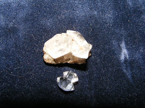
Herkimer Diamonds
How To Protect The Treasure
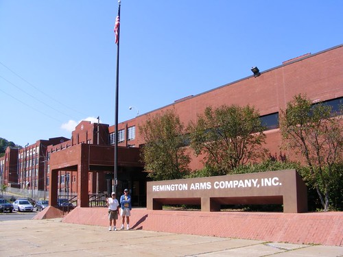
The next day we walked 2 miles to tour the Remington Arms factory and museum in Ilion. Eddie didn't think it was a good idea to wear his new peace symbol jewelry to the gun factory. It was a pleasant walk through the little towns of Mohawk and Ilion, right along their main streets. I saw this sign painted on the side of a building. We bought corn from a little unmanned stand set up in front of someone's house, and you put the money in an ammunition box.
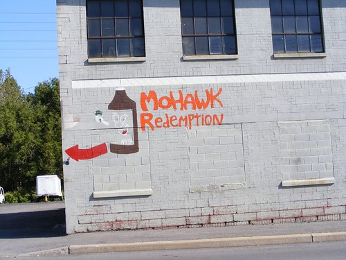
Not For Saving Indians
I had to laugh because when we were in Maine I kept seeing similar signs and thought they were some sort of religious enterprise. It took me a long time, and closer observation, to figure out they are places where you are supposed to cash in your recyclable products that originally required a deposit.
Where To Prepare For "Change"
The Remington Arms factory has been in production since the early 1900s and still employs almost 1000 people. In fact, they have added employees since the beginning of the year to meet the increased demands for rifles which have occurred since the Democrats were voted into office.
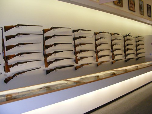
Rifles That Shaped History
The museum has displays of firearms which trace their historical significance. Paintings depict sporting art. You learn that Remington also manufactured typewriters, sewing machines, bridges, farm equipment, and knives.
The highlight of the visit was getting a factory tour which took us through all the phases of manufacturing, including the area where the custom rifles are made by real craftsman. Some of the rifles costs up to $30,000 because of the special engraving in the wood or metal that is required. It was interesting seeing the varied type of equipment that is used in the manufacturing process, some of it still from the first factory days to new, high tech laser equipment of today. Annie Oakley, Little Miss Sure Shot, who owned a Remington 22 rifle would even be impressed!
Tomorrow we will travel the farthest since we began our voyage on the Erie Canal.
After leaving Canajoharie we traveled 17.7 miles and tied up on the east side of Lock 17 along the lock wall. There was a lot to see and do in this area, and we picked an excellent spot to be able to watch activities at Lock 17 and access the town of Little Falls.
Exiting The Big One
Lock 17 is unique to the NYS Canal system in that it has a vertical lift gate, one of two in North America; the other one being in Ottawa, Canada. Boats are raised or lowered 40', requiring 5 million gallons of water. When boats go under the gate, water drips on them (and line handlers standing outside!).
We have experienced some turbulence when locking through the bigger locks and wondered how we would do in Lock 17 when we had to go through it. I was talking to lock operator Scott, a congenial, chatty man, and he told me that deeper draft vessels should pull far forward and ask for a slow lift. That way the water flow coming in to fill the lock will be slowed down and not push us so hard into the wall, minimizing our fenders being crushed and not having to push to keep FLUKE off the lock wall. We followed his advice when we locked through, and we had less movement than when we had locked through the 30' high locks.
Locking Through On Foot
Like a lot of the present lock sites, Lock 17 is adjacent to one of the phase 2 Erie Canal abandoned locks, over 150 years old. I am standing right where one of the old gates would have been located, where the blocks have a rounded edge. Notice how tight the blocks fit together, with no mortar, and what great shape they are still in. The stone work is so perfect and uniform, all of that work done in a time when there weren't any power tools available.
Moss Island Hikers
You can access Moss Island by crossing over the top of Lock 17. There are several informative displays which help explain some of the geological history of the area and why it is so unique. Moss Island, and the area on either side of the river in this area, is composed primarily of syenitic gneiss (pronounced nice) which are some of the oldest rocks in geological history and comprise the ancient roots of the Adirondack Mountains. The rocks are smooth to the touch, and Moss Island has trails that weave in, out, over, and around all sizes and shapes of boulders. Some jut right out over the river, providing spectacular views of the water below and adjacent mountains above. There are places where ancient water flows carved out circular tunnel shapes through the rock and look as though someone took a gigantic auger and drilled through the rock and then smoothed over the sides.
Water Carved Rock
On the outer boundaries of the island, where the rocks are not directly adjacent to the water, a large rock mass fronts the canal area with an adjacent land path. Rock climbers scale the boulders, some with all the rope gear, dangling themselves over the upper ledges. Other climbers scale the rocks with their bare hands. People gather just to watch the climbers, and so did we.
Where The Climbers Hang Out
The path visible in the above photo is on the north side of the canal and is an easy, picturesque, way to get into Little Falls. The electric poles in the photo are associated with the local power plant that utilizes the water from the canal and river to produce clean energy to power 8,000 homes. You have to walk over a grated area that is part of the power plant's intake area. It is safe and secure, but dogs hate to walk over the grates because their toes get caught. The power company made the walkway dog friendly by putting in rubber matting in a strip with a sign saying “Dog Path”.
Fishing At The Falls
Little Falls appears to be the most prosperous town we have visited so far on the Erie Canal. The area is the narrowest point in the Mohawk Valley, site of a natural deep gorge, just with tumbling cataracts, not waterfalls. It originally prospered as a mill town (there are no mills left) and a cheese producing area in the mid-1800s. One factoid stated that 380,000 lbs. of cheese were sold at the cheese market in a single day for “export” from the area.
A walk around town shows well kept period homes. The downtown area still has a lot of businesses in operation and has a small town feel to it, and it is possible to shop for small amounts of groceries, hardware, health and drug items, and there is even an operating motel and cinema. Canal Place is a site of a few boutiques, restaurants, and antique shops. Our favorite store turned out to be the Community Co-op which sells fresh produce, bulk spices, lots of organic foods, and similar specialty products.
A Canalway Trail, a paved path, is located on the south side of the lock area and canal, and you can access Little Falls by taking that as an alternate route. It was once the old railway route, and you walk through areas of the gneiss stone formation which had to be blasted out for the railroad, and you even go through a tunnel.. In the winter the trail is used for cross country skiing.
Canalway Trail
Taking the Canalway Trail 1 ½ miles east from Lock 17 will take you to the Herkimer House Historic Site. The 1764 home belonged to General Nicholas Herkimer who is credited with winning the Battle of Oriskany during the Revolutionary War. It is a pleasant walk to get to the site; you walk from high up on the side of the mountain to down right next to some swamp land. We passed over a flowing stream, and Eddie and I scampered down into the stream bed to look for Herkimer diamonds and interesting rocks. I found a big mammal bone of some kind. Hopefully it wasn't a human bone because I left it on one of the display plaques at the Herkimer House, and it may cause a real mystery. We don't need to have that added to our “rap” sheet for this voyage!
Herkimer House
Now that I've mentioned the Herkimer diamonds I need to explain what they are. Through millions of years of geological forces, water rich silica was turned into clear, hexagonal quartz crystals with points at both ends, which came to be called Herkimer diamonds. Local rock quarries mine an area that has several veins of the quartz running through them. The rock is used for fill, driveways, and construction projects, and it is common to find the quartz crystals embedded in the rock or “pure” by themselves, all of varying quality. A couple of the quarries allow visitors to try their hand at “prospecting” and dig for the diamonds. I would have loved to have spent some time doing that, but the mines were too far to walk and would have taken up too much time from our other activities. So, I put it on my “list” to try to buy a diamond along the way while we were in the area. That proved much more difficult than what I thought it would. I figured my best chance would be at our next stop, Herkimer.
Use The Woods Instead
We only had to travel about 10 miles to dock where we would have good access to the town of Herkimer. This stretch of the canal is not very scenic, and it was the first time we have seen significant work being done on the canal itself. We always enjoy seeing the construction equipment, and all the NYS Canal equipment is painted their standard gold and blue and looks great.
Work In Progress
These workers were involved in part of a dredge operation. Notice the big arrow on top of the dredge directing river traffic to go left. The tugs we have seen range in size from little ones like this to ones 80' long. If you look closely you will see a porta potty between the tug and the crane barge. I found it amusing that the porta potty was actually on its own little floating platform and must just get pushed around like that to the different sites.
Floating Mud?
That mud isn't really floating; it is on a mud barge. When we approached, they had to move the barge out of the way for us to pass by, and they called us on the radio to ask us to stay back until they were able to move it far enough. The mud barge has large open “bins” that can be filled with the gunk and debris that gets scooped out of the river. When it is filled up, like you see in this photo, it gets moved to another location where it can be unloaded. The debris above the deck level can be picked off, but the material left down inside the bin, below deck level, can't easily be scooped out. So, they pump water into the bin and make a slurry out of the stuff and then suck it out and deposit it to a shore side location.
We went through Lock 18 and 5 miles later pulled up to a free dock at a place called Gems Along The Mohawk. Sounds like a place I should be able to get some of those diamonds, huh? We are now at an elevation of 383'. This place is right by Exit 30 of the NY Thruway, and the traffic noise is awful, the most of any stop we've made. Cruisers like to stop here because there are major shopping opportunities within reasonable walking distance.
Gems Along The Mohawk is a typical tour bus stop where you can get off the bus, have a meal at a place called the Waterfront Grill and then shop in the store for all kinds of souvenir items representing commerce from the area. They have some of the diamonds, but they are all in pure crystal form, ready to be made into jewelry, or already a jewelry piece, not what I had in mind. I really wanted to find one still embedded in the rock, which they had, but for display purposes. Oh, you can also take an Erie Canal tour here on a pontoon boat; you get a canal history and go through a lock, probably worthwhile.
Since we were going to check out the town anyway, I thought I might find some at a shop in town. I asked at a couple of places, but most people just go to the mine to get them directly and don't resell them. I figured my best bet might be a junk or resale shop, where you can find anything.
I spotted a shop called Cosmic and asked a couple of people waiting for a bus what it was. They said it was a head shop, but thought they might have some crystals too since some people think crystals and drugs go together.
Eddie and I checked out the place, and a nice woman, our age, was running it for her son. She had some of the crystals, but they were for display. Eddie's mind wandered back in time as he looked at all the new versions of drug paraphernalia, jewelry, and clothing. He ended up buying a peace symbol necklace, bracelet, and earring. Isn't it nice to know I could borrow his stuff if I needed it for that special outing?
Still searching for the diamonds, I walked into a junk store and told the guy what I wanted. Even though he didn't have any in the store, his mother was running their “branch” store a couple of blocks over, and she had some there. He would call ahead and let her know we were coming.
Well, she had a lot of the diamonds, piles of them, all of varying degrees of clarity and purity. We spoke at length of how they were acquired, and I found a small one attached to a tiny piece of rock that I figured was going to be the best that could come to my specifications. She was a wheeler dealer and showed me a pure diamond that she called a twin, which were two small perfect crystals joined together. They were very pretty, and she said I could have them for $10. While I agreed they were nice, I really wanted the one with the dirty rock attached, so she said I could have it for $5, and we struck a deal.
We weren't done with her though, because I had to show her my gem. I went outside and brought in Ursa. I already had found out she was a dog lover (she had pugs), so I knew she would get a kick out of Ursa. I put Ursa through her trick routines, and the woman loved it. She said she liked me so much, she wanted me to have the twin diamonds as a gift! I've tried to take a picture of the treasure.
Herkimer Diamonds
How To Protect The Treasure
The next day we walked 2 miles to tour the Remington Arms factory and museum in Ilion. Eddie didn't think it was a good idea to wear his new peace symbol jewelry to the gun factory. It was a pleasant walk through the little towns of Mohawk and Ilion, right along their main streets. I saw this sign painted on the side of a building. We bought corn from a little unmanned stand set up in front of someone's house, and you put the money in an ammunition box.
Not For Saving Indians
I had to laugh because when we were in Maine I kept seeing similar signs and thought they were some sort of religious enterprise. It took me a long time, and closer observation, to figure out they are places where you are supposed to cash in your recyclable products that originally required a deposit.
Where To Prepare For "Change"
The Remington Arms factory has been in production since the early 1900s and still employs almost 1000 people. In fact, they have added employees since the beginning of the year to meet the increased demands for rifles which have occurred since the Democrats were voted into office.
Rifles That Shaped History
The museum has displays of firearms which trace their historical significance. Paintings depict sporting art. You learn that Remington also manufactured typewriters, sewing machines, bridges, farm equipment, and knives.
The highlight of the visit was getting a factory tour which took us through all the phases of manufacturing, including the area where the custom rifles are made by real craftsman. Some of the rifles costs up to $30,000 because of the special engraving in the wood or metal that is required. It was interesting seeing the varied type of equipment that is used in the manufacturing process, some of it still from the first factory days to new, high tech laser equipment of today. Annie Oakley, Little Miss Sure Shot, who owned a Remington 22 rifle would even be impressed!
Tomorrow we will travel the farthest since we began our voyage on the Erie Canal.
Subscribe to:
Posts (Atom)


