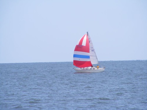
Chesapeake sailors
We're finally on the move again, probably won't set foot on land for at least 6 days if everything goes as it should, more if we get hung up with weather. It would have been easy to stay longer in Great Bridge, but we had done all we really needed to do, and we were falling a bit behind in the cruising schedule. I feel really good that we're underway again. I will now have a chance to fill you in on some of the things I've left out and thought about adding after a post had already been made. Plus, I can give you a better feel for how we are passing time underway and why I'm not bored.
Technically, we should have been in Waterford, NY by June 1 to get to the northern areas of our destination in a timely fashion to take advantage of the weather conditions that usually dictate the comfort of travel up there. However, Mother Nature dealt that cruising area a hard blow this Spring. The locks usually try to open by May 1, but because of extensive snow melt and additional rain, they were not fully open until June 1. Water had flooded over the tops of the locks and the waterways were impassable. We knew that was happening and didn't want to get stuck in the log jam of other cruisers who had more rigid schedules to adhere to, so we were just tooling along and enjoying those backwater towns of North Carolina.
For one thing, I've been trying to keep up with writing the blog in a more timely fashion than I have in the past. I can't get this thing written by just sitting down for half an hour and letting my fingers flash over the keyboard and have everything just gel together in a sensible fashion that I think is interesting for you readers. I keep a written journal that I generally update at least once/day and many times I write things down as they have just happened because I think I'll forget it later. I like to think that is because I have so many things going on, but deep down I really know it's age-related signs of CRS (can't remember shit). I record info I get from people, signage, or cruising guide references. Plus, I've really upgraded my efforts to document activities with photographs since so many of you have requested that. The pics help me remember things too. Sometimes that drives the guys crazy because I'll jump up and push them out of the way to get the camera or ask them to take over at the helm if I see a photo op. However, in the end they agree that the pics enhance the whole story. Here are a couple of pages from my journal so you can see there is some extensive writing, legible only by me according to my crew mates.
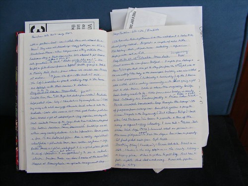
My daily journal
More timely postings are also being accomplished by an upgrade in our ability to access the internet. First, we have a new long-range WiFi adapter, and when it is not available we can use our cellular data card with a new amplifier and antenna. Also, unlike when we're in the Bahamas, the internet is simply more available to be accessed since we are within range of closely populated areas. In fact I'm writing this right now as I look out upon the Salem, NJ nuclear power plant facility supplying those kilowatts to millions of hungry meters and their homeowners just over the horizon. The massive concrete, sterile-looking facility has never looked as nice with the later light of day reflecting in the adjacent waters of a rarely calm Delaware Bay.
Eddie has been bugging me to add an addendum to the Edenton blog post whereby I told you about the Roanoke River lighthouse renovation. The sign describing the project said it had been partially funded by “stimulus” money from the American Recovery & Reinvestment Act of 2009. Poor Eddie was crushed to think those kinds of funds weren't just used for building roads and bridges or other types of infrastructure to help keep the country operating. His idea of “shovel ready” meant that you needed to use a shovel to do the job. He even wondered out loud if the new Visitor's Center at Great Bridge had gotten some of that money too.
We are generally very willing to have complete strangers, especially other boaters, come aboard FLUKE for a tour while we are on a “cruise about”. However, I just have to tell you about an incident that happened in Columbia. Eddie and I were in a soon-to-be-not Ben Franklin store, kind of like an old Woolworth store. A woman was in there with her 3 kids, 2 boys about 6 and 8 years old, and a girl about 4. They were running wild all over the store, and while the woman was checking out, the girl picked up a tube of lipstick, opened it up, smeared it on her lip area, and then bit off the end of the stick. A salesman pointed it out to the mother, who got to the kid in time to pull the bitten off end out of the kid's mouth before she could swallow it. We left the store right behind the whole gang, with the mother trying to clean up the kid, who was still clutching the lipstick tube. After a block or so, we passed by the whole gang to head back to FLUKE since it was lunchtime, and we knew we would be in BIG trouble if we kept Captain Wayne from adhering to the noon feeding schedule.
Shortly after we got back to FLUKE, the woman and her kids showed up. They were all running around the waterfront, really giving FLUKE the eye. Eddie walked out in the cockpit, and the woman said “I want to see this boat, and one of the little boys said “Can we come inside?” Eddie told them we were getting ready to eat lunch. The woman said “I'll be back”. We watched them wander away towards the Visitors Center and thought that was the end of them. Alas, the whole gang was back in about an hour and a half. The boys started throwing rocks into the water to get our attention, but we laid low until they finally gave up and headed out of sight back up main street
I guess I've filled you in with enough leftovers for now, so I should try to bring you more up to date on life aboard as we are underway, making wake everyday.
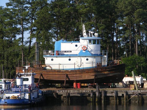
Stubby like FLUKE
Shortly after we left Great Bridge on the morning of the 4th, we timed the bridge openings to be able to stop at Top Rack Marina, adjacent to the Steel Bridge, at 8:00 a.m., right after they opened for business. The area is a mix of heavy industrial and residential. In fact, TRM has a condo and restaurant on site and it's right next to a busy highway bridge, across from a marine industrial site where this cute little tug was high and dry. The cruising community does a great job these days of networking when it comes to fuel prices (which can change daily!), so we knew would could get the best price at TRM. We took on 363 gal. of diesel at $3.45/ gal., so you can see why we have to watch the price. We filled our water tanks and pumped out the sewer. I always breathe a sigh of relief when I see a decent sewer sucker and when we complete the job without an “incident”. Some really nasty things can happen when you have a sewer pump out failure, and that isn't a pleasant way to start a day.
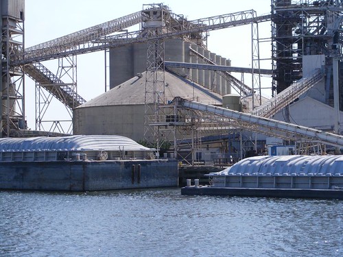
Barging in
We would next have to spend a couple of hours transiting the busy industrial waterfronts of Norfolk and Portsmouth, VA. There is always something going on. This is a good example of how the barges are loaded using chutes or conveyors. The one barge sitting high hasn't been filled yet. What you don't see when a full one passes you is that there is usually another 10 feet of the barge's cargo area below the waterline.
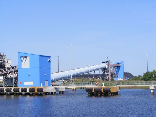
Remember the game Chutes and Ladders
I am always amazed by this operation, but have never been able to see any “product” being loaded onto a vessel using this complicated series of chutes and conveyors. There is a big processing facility of some kind that the chutes connect into, and considering it is truly an industrial operation of a large magnitude, the site always looks pretty clean.
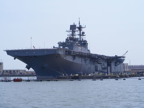
Small aircraft carrier
Parts of the U.S. Navy operations are visible on both sides of the waterway as we creep through Norfolk and Portsmouth. You never know what kind of vessels you will see in dry dock or being worked on in the water. We love looking at the Navy vessels, which, now-a-days, are maintained with floating fenced perimeters and water guards. I noticed that the submarines had armed guards dressed in black combat gear stationed in the conning towers.
There are a lot of huge marina terminal gantries for commercial shipping to load and offload freight or petroleum products. We have always passed or seen docked freighters or tankers, but this time we only went by one underway. I think that is a sign of how poor the economy is; we aren't sending much goods out, and we aren't getting as many goods or raw materials for manufacturing shipped in.
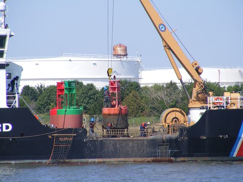
Channel marker maintenance
We saw this Coast Guard ship cleaning and painting the navigational markers. Notice how much of the marker that you can't see is submerged under the water. They have that big crane to pull out the heavy markers. Then they have to be scraped off before they can be painted. They have a lot of job security in the Norfolk area; there are SO many markers.
Once you get out of the congested area of Norfolk you enter Chesapeake Bay and the water world becomes wide open. There are so many kinds of vessels of any size you can think of; you have to be on the lookout for those going too fast or too slow. The first time we came here I was worried that we would have a difficult time finding a place to anchor each night. I laugh now as I have learned that since we are “hookers”, there is always someplace to go to anchor. There are so many rivers and creeks that branch off the Bay that with easy planning you will always be able to find a safe place to sleep. Anchoring out gives us so much more freedom to stop or go as we please since we do not need, nor are we committed to, having to stop at a marina. Most of the major rivers and/or land masses that jut out into the Bay are marked by lights of varying sorts. Wolf Trap light, at the southern end of the Bay is an important one for using as a directional reference. These old lights are getting in a sad state and need to be “adopted” for renovation. In a previous blog for another trip, I wrote about that having happened to the Baltimore Light. Maybe Eddie should campaign for some of that stimulus money to be funneled to Wolf Trap!
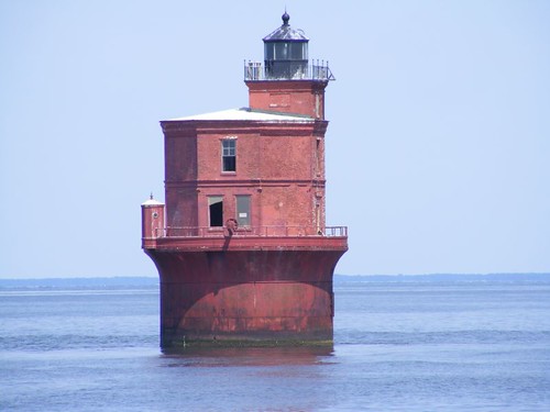
Wolf Trap light
We ended up traveling 85 miles the first day to anchor at Sandy Point, right inside the entrance to the Great Wicomico River. Not too far away was the menhaden fishing fleet and processing plant at Reedville. If you had vision problems you would still know you were going by there from the odor in the air! Fortunately the wind was in our favor that night, and we didn't have to go to sleep smelling the fish oil.
The following morning we exited the mouth of the river in a short-lasting thunderstorm. Despite minimal rain and wind, the waters where the rivers intersect the Bay often have a lot of turbulence because of the conflict of wind and current. We had a radio conversation with some friends who were leaving from their anchorage at the next river south of where we had been and they were turning back because of the rough water. We, of the mighty FLUKE, forged onward and the winds settled down enough to provide another decent cruising day up the bay.
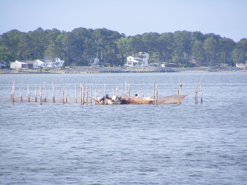
Fish on a stick
Fortunately boat traffic moves in a logical fashion on the Bay. There are designated shipping lanes for the ocean-going and huge commercial vessels. So, if you stay just outside their territory, you will be relatively safe. You have to watch carefully when you get close to shallow areas because there are many crab lines or pots, and these things called fish traps. You can see that they look like a bunch of sticks in the water. They are located on shoals, where schools of fish swim through. The fisherman string their nets onto to the poles according to how the tide is flowing and the fish swim in. This fisherman is pulling up the nets and loading his catch into his boat.
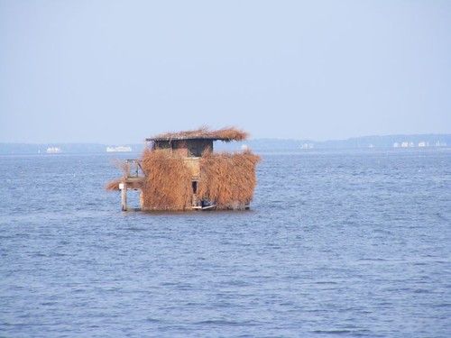
Hilton duck blind
The shallow areas at the mouths of a lot of the rivers have duck blinds. As we were heading into the Rhode River to anchor on the night of June 5, 86 miles for the day, we passed this particular blind. It was done up so nicely; most of them look real ratty and like they would fall over if you got in one. We had anchored here before so we knew what to expect: lots of late afternoon boat traffic because the area is surrounded by residential homes and a YMCA camp. They all go away as soon as night falls.
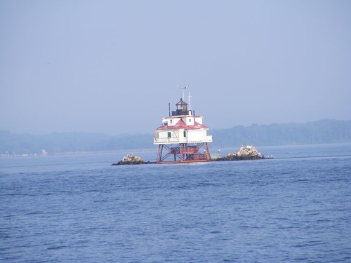
Thomas Point light
When we left in the morning it was light enough to get a photo of the Thomas Point Light, just south of Annapolis. You can see how different it looks from the Wolf Trap Light, but they all provide such interesting Bay scenery.
That area is a layover anchorage for freighters waiting to move farther up the river, probably to Baltimore. Foreign registered vessels are required to have an American pilot at the helm for moving the ships around most parts of the Chesapeake and Delaware Bays. We had to go between a group of four of these big guys. Notice which one has cargo and which one doesn't by how high the water lines are on the hulls.
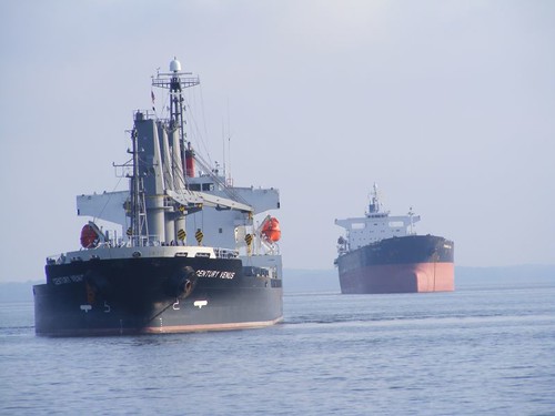
Full and empty
If you keep your eyes open, there is plenty to see. This photo shows the sailboat in the background catching some good wind, so you know these Coasties had their hands full trying to make repairs to the lighted navigation marker with everything moving about.
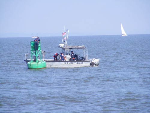
Hand me the bulb
The scenery changes as you move up the Bay with less congestion and more, pastoral open areas of big residential estates or even some farms. We were traveling closer to shore so it was interesting seeing the sloping, manicured land coming right down to the Bay shore.
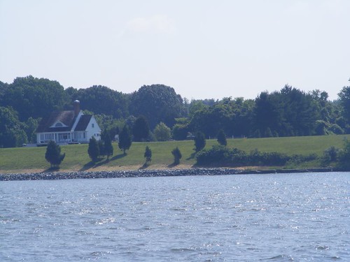
How it looks from the Bay
I was looking forward to transiting the C & D Canal.


0 comments:
Post a Comment