Our cruising adventure took a great swing, going from the country solitude of Lock 21 to the cheesy, hustle bustle, of the summer resort town of Sylvan Beach. It is a throwback to the 1950's, so if you are nostalgic for that era, this would be a good place to visit.
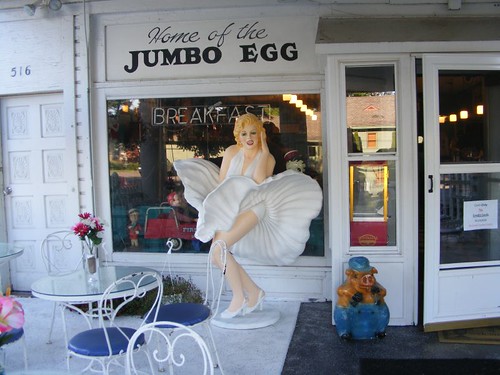
You can swing with Marilyn
When we were here in 2009 the summer tourist season was already over. The lakeside amusement park had closed, so this time, being in the prime time of summer we knew we may have a problem finding space to tie up. Our chances of getting space were improved because it wasn't a weekend and it was rainy weather. We tried to time our arrival by guessing when cruisers would be pulling out for the day. We were a bit too early, but managed to find a space at the wall because another cruiser was kind enough to pull his boat forward and another one left.
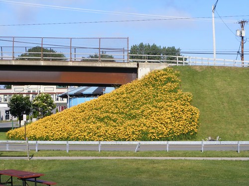
Day lily bank
We could look out the boat and see this pretty bank of day lilies. They caught the eyes of quite a few people, young and old. People would climb into the flowers and sit or lay down to have their pictures taken. It didn't matter to them what the flowers looked like after they were done with their photo session.
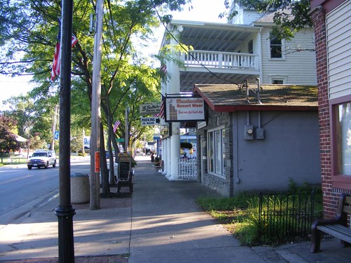
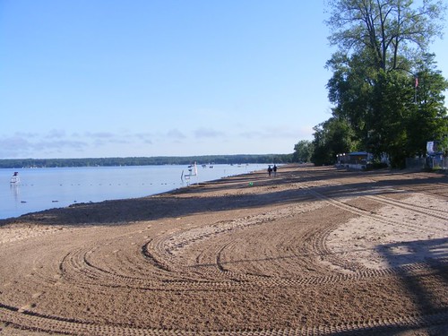
Before the action started
This street scene was shot before the summer tourists were even out of bed. There is one main street in town, and it only goes for a few blocks. The rest of the town is made up of the amusement park area, the beach area, the bar/restaurant/rental cottage section, and then the residential section, which is mostly only occupied during the summer. There are few buildings of historical significance, no sprawling garish motels, and no multistory buildings. The whole area has a wonderful tree canopy which softens all the signs and buildings and makes it nice to walk anywhere around town. Most of the real summer residents appear to have an interest in boating or fishing out on Oneida Lake.
Between the trinket shop and pizza parlor
The weekend tourists visit to go to the “beach”, where Sylvan Beach gets its name. Adjacent to the amusement park, the wide, lake beach is raked and cleaned daily, has lifeguards and protected swim areas and has fabulous sunset views, being on the very east end of the 20 mile long lake.
Ready for a new day
The FLUKE crew, being spoiled from our beautiful Florida beaches and all those we have “discovered” on our Bahamian adventures, couldn't get too excited about this one. I'm sure we would feel differently coming out of one of their cold, gray winters though.
When we were here in 2009, we were walking through the residential area and happened upon a private garage where we spotted a couple of classic coupes from the 30s and 40s in the process of being restored to prize condition. We were craning our necks to ogle them when a man stuck his head out and invited us into the garage. So, this year, we were hoping to see that Al was still at it and what new project he may be working on.
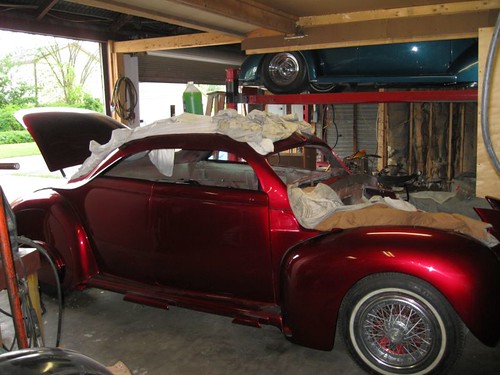
The 40 Ford coupe
That red color was so “deep” I thought we could see all the way back to NYC! Eddie had to hang out with Al, have a couple of beers, and reminisce about how he used to jazz up his own cars as a teenager. I told Al that Eddie may want to spend the rest of the summer with him, and I think Al would have like that.
A Tuesday morning Farmer's Market was just getting started for the season. Despite having limited selections, I still managed to get some strawberries, radishes, and zucchini. Eddie scored big for the crew with cookies, an apple pie, chocolate cake, and nut bread. We have such balanced diets.
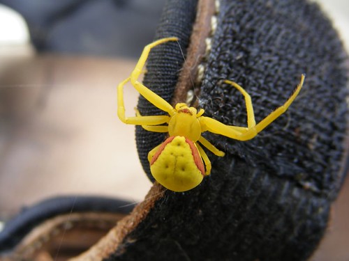
Goldenrod spider
Right as we were getting ready to leave the wall, we noticed we had this colorful stowaway aboard. It had to be sent back to the dandelions where it could blend in safely.
We received a report that Locks 12, 13, 14, 15 had been temporarily closed due to high water from all the rain we had been having. We were glad that we had already passed through them. Our plan was to cross Oneida Lake, stop to take on some fuel (so we would have enough such that we wouldn't have to worry about buying any in Canada and could make it all the way back to the Chesapeake in Sept.), and pump out the sewer.
We had okay weather crossing the lake, but as soon as we exited the lake and got back into the canal, now the Oneida River, we could see a storm looming. Right as we had tied up to the fuel dock at our destination, the sky opened up with pouring rain and lots of lightning. It was not a good feeling sitting right next to the fuel pumps, especially having been told that the facility had been hit several times by lightning already. When the storm ended, we took on 200 gal. of fuel at the “great” price of $3.99/gal.
Lock 23 was our destination for the evening, and it was only a few miles ahead. When we had gone through it in 2009 we had noted that it looked like it would be a peaceful place where we could tie up. It is a popular fishing spot with the locals, so it was fun to watch people catching some fish. You can take a quiet walk into the rural countryside from the lock area. I managed to pick some black raspberries without getting into any poison ivy, which is abundant and very robust at this stage of the season.
Lock 23 dropped us another 7', and in just 7 miles we reached the Three Rivers junction, a tee in the waterway. The Erie Canal continues to the left on the Seneca River, and we would turn right on the Oswego River and the Oswego Canal.
The construction of the Oswego Canal started in 1826 and only took two years to build. It was constructed right on the bank of the Oswego River, and parts of it are still visible from the river today. Oh, how I would love to have one of those old, beautiful stone blocks sitting in my yard at home!
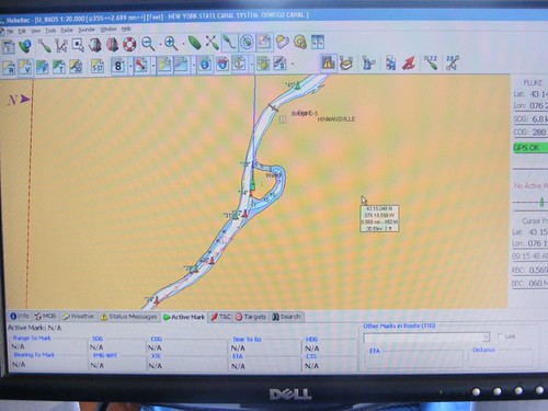
The river oxbow
In the early 1900s New York State decided to use the natural waterways as part of a new canal system that would accommodate larger, motorized vessels. So, they dredged the rivers, making them wider, deeper, and straighter to allow river traffic to flow faster and safer. This photo (taken from our chart plotter that we use for navigation) shows one of the original river curves, an oxbow. The little island in the middle is very high and covered with trees, picturesque to say the least. The Day Peckinpaugh, a 256' barge boat, traveled the canal up until 1994, so you can see how useful it was to eliminate the oxbows even in modern times.
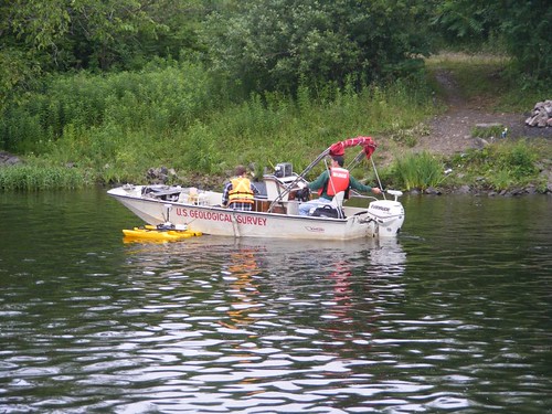
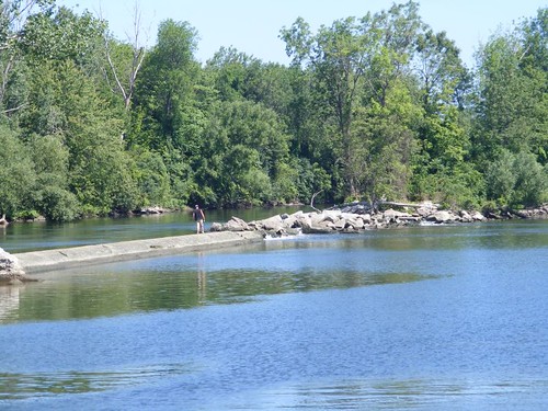
River research
When we passed here in 2009 we saw the yellow instrument next to the boat floating in the water with a flag on it, and we figured it was some kind of water monitoring device. I laughed this time when I saw these men with it next to their boat, probably retrieving data from it. How I would have liked to ask them dozens of questions about the data they were collecting! It would drive Wayne and Eddie crazy, not that that is one of my goals intentionally.
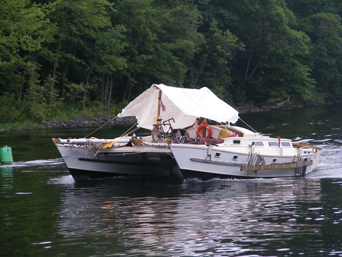
Covered catamaran
This catamaran passed us, headed in the opposite direction. They were creative in trying to give themselves some protection from the weather by covering their whole boat, but we didn't know how they managed to see out the sides.
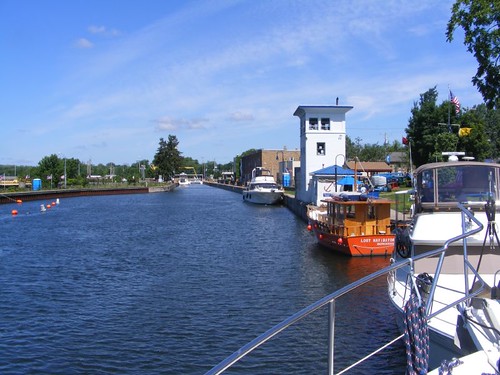
Oswego Lock 1
Lock 1 is in the village of Phoenix, a great place to stop. This community loves the cruisers, and goes out of its way to help out and make you feel welcome. In this photo you can see the terminal wall and extended docking facility. You can tie up here and have power, water, and WiFi for free. The tall white, 3-story building is called the Bridge House. It contained the controls to once lower and raise a drawbridge. The little building next to it is called the buoy house, where the canal workers stored the buoys used on the canal during the winter months when the canal was closed. Now the buildings are used as a tiny canal museum and gathering place.
Notice the orange boat in the photo. The captain built it himself; we called him Lost, after his boat. That is not unusual, as many times you never do get the name of a cruiser, but you can usually see the name of their boat. Sometimes I even say to people, “I'm one of the FLUKESTERS”.
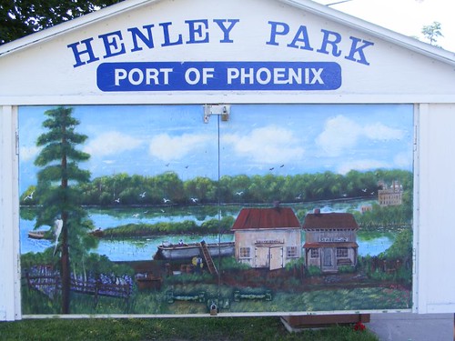
Where the tour begins
Henley Park is the name of the area next to the bridge house. There is a nice pavilion that is used daily by the locals. This is the only place we have ever seen that welcomes ducks. They even have the Duck Hut, where seed is put out for them. This time of year, there are lots of mallard families. The wide open grass area is used by local kids who actually come from inside their houses to help cruisers with odd jobs (They are called the Bridgehouse Brats) or play outside games. One day an entire group spent the whole day playing a ball game, until just after dusk. I wanted to ask them if they had lost power to their homes and couldn't watch TV or play video games, but Eddie yelled at me and said I would be giving them bad ideas.
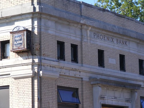
You can bank on Phoenix
Because of its location on the Oswego Canal and close proximity to Lake Ontario, Phoenix became a thriving village in the late 1800s, with several industries and retail establishments: boat-building, furniture manufacturing, a distillery, and silk mill. All were built right on the bank of the canal and could be accessed from the land by road traffic or by the waterway's canal traffic. The community prospered culturally and economically. All of that changed in 1916, when a fire broke out in one of the mills. 2/3 of the taxable value of the village was destroyed (80 buildings), and the businesses were never rebuilt. Today the village has about 2000 residents.
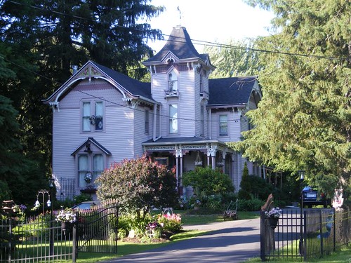
From the old days
The fire was able to be contained to the canal front, so most of the private residences were spared. A walk around the pretty village reveals some interesting homes and churches. You must pay attention to where you walk since the sidewalks are in quite a state of disrepair from weathering and tree growth. All the residents must have to sign disclaimers saying they can't sue the village for tripping or falling.
On the opposite extreme, in my category of “What ever happened to personal responsibility?”, is the safety features of the bridge by Lock 1. If you look in the lock photo, you will see a huge yellow “arm”. That is used to lift the bridge up for high boats that exit Lock 1, a drop of 10'. The bridge is hinged on one side, so the lockmaster lifts the bridge up high enough based on how much clearance a boat needs; it isn't all the way opened or closed. One of the local roads travels over the canal, so when the bridge is open, the traffic has to stop. The bridge has a bell alarm, crossing gates with lights, and a wire mesh net that also gets lowered when the crossing gates come down.
Dividing dam
After Lock 1, the canal twists and turns; there are many interesting sites, and the time passes quickly between locks, so you have to be ready to go through the next one. Fishing is a popular pastime along the banks, in boats, and at the terminal walls. Some have extensions like this one to deflect the water and help control flow.
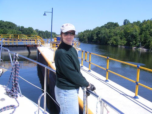
Line handler
The lock drops on the Oswego River range from 10 to 27'. In this high lock, you can see the scenic vista in the downstream distance. Notice that I'm wearing jeans and a sweater, and it's almost the Fourth of July!
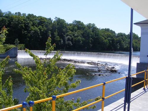
Lock dam
This was the view upstream from where I'm standing. It is one of the prettier river dams, used to control the water for use in one of the several hydro plants along the river. They are all older-looking, low profile brick buildings that fit in well with the feel of the canal system.
The power plant adjacent to Lock 7 retains water for a certain period of time and then discharges back into the river which may cause a change in the water level. Some people like to fish at the base of the dam and along the shore line downstream. When we were here in 2009, there were signs along both sides of the river telling people to be alert for water level changes and a siren would sound when the water was about to be discharged. Last Spring, a fisherman drowned. So, in addition to more signs, another safety feature has been instituted. It is an extremely loud siren alternating with a recording that says “Attention: river levels are rising rapidly. For your own safety, please leave the river immediately”. It runs for 5 minutes, repeating 7 times. It is truly obnoxious.
We learned this well because Lock 7 is on a restricted opening schedule, limited to 5 times/day. There are fissures in the lock wall, and they are hoping that, by minimizing its use, they can get the lock through the cruising season and redo the walls during the winter when the lock will be drained. We had decided to time our arrival for the 2:30 p.m. opening. However, we wanted to make sure that we had a “spot” in the lock, knowing other boats would want to lock through then too, so we arrived at the upstream tie off wall at 1:00 to have lunch and be able to get off the boat and look downstream on the other side of the lock where we hoped to tie up if space was available.
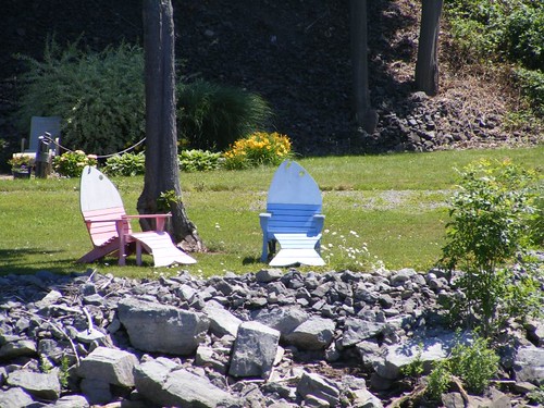
Not for fishing
While we were waiting with the siren blasting and that recording screeching through the trees, I was thinking about the people upstream relaxing in these nice chairs watching the quiet river slowly gliding by. The FLUKE crew could relax soon after we locked through and safely tied up in Oswego.


0 comments:
Post a Comment