May 21, 2012
By the time you are reading this post, you will probably be wondering how we have fared with the low pressure system that has persisted over the southeastern U.S. and most of the Bahamas for the last 10 days. It is the one that has spurned the first two tropical depressions of the 2012 hurricane season which doesn't officially start until June 1. While we haven't had to deal directly with them since they moved way north of us, we have had the tail of that moist, unsettled weather that fed their birth. We have NOT been happy cruisers.
For all the years we have been cruising the Bahamas, we have never cruised to Eleuthera and most years, never even talked about doing so. There are several reasons, the biggest one being that there are not many places to hide out comfortably during bad weather, and even more importantly, there are fewer places to anchor if you are expecting an unfavorable weather shift relative to where you are anchored, and they usually occur in the middle of the night when you are asleep and can't see anything. The open ocean east side of Eleuthera has no places to get into out of the ocean. The shallow water west side of the 100 mile long island is mostly wide open to the west and only has a couple of harbors that give you all around wind protection. Fishing and diving are very limited on the west side. So, over all, there isn't much appeal for us to cruise these waters. We decided to this year with the idea we would just spend a couple of days looking at the unusual coastal terrain since we had never seen it before.
Things started out fine, conquering our first challenge of the day, Current Cut, with no problems. Current Cut is a deepwater, narrow cut through the north end of Eleuthera, so when the tide is at a maximum flow, the speed of the current can be as much as 6 KTS. Therefore, slow boats like FLUKE are best advised to wait until the tide is close to slack to go through the cut. For us, it meant that we would have to wait until 10:00 a.m. for high slack, which was fine since we also needed to have good light to be able to read the bottom once we made it through the cut. The following is a nav chart section showing the cut and relevant info.
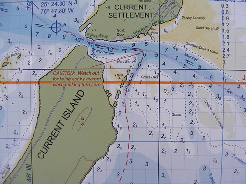
Current Cut
We traveled from west to east, left to right on the chart. After you get through the cut itself, you have to make a sharp right hand turn to stay in the deep water and not drift onto the shallow sand bars to the east. That is another reason to make the transit at slack – so you don't get pushed by the strong current onto either the sand bars or the rocks to the west. The water is crystal clear, and we could see many tracks in the bottom where boats had gone on low water or had strayed out of the deepest part of the channel.
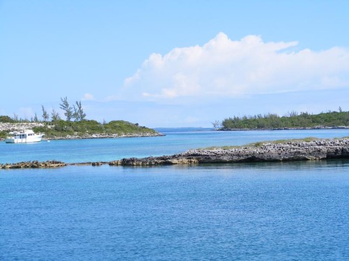
Like a rose
This is what you can see looking back through the cut. It is quite picturesque, but full of hidden dangers that you need to be aware of or you will be in big trouble if you make the wrong move or go at the wrong time.
It was so nice to finally have a calm, sunny day while underway. We could see everything on the sandy bottom, only about 10' deep. A dolphin riding the bow wake appeared to be in the air rather than in the water.
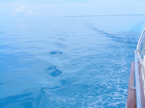
Our kind of seas
The water is deep very close to the western shoreline, so you can get in close to see the big cliffs, some of which are 100' high. The predominately limestone rock weathers and erodes at different rates, leaving areas with huge sea caves and blow holes where storm-pushed water can shoot up and make big sprays. Some houses seem to be precariously perched close to the edge.
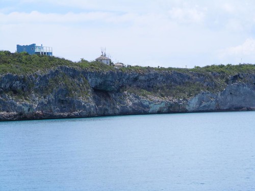
Cliff houses
Some homeowners went to great lengths to be able to have access to the water for swimming. No docks are even possible because the shore rocks are straight up and down and the water is deep, so when the westerly winds pick up they move a lot of water into and up the rock face.
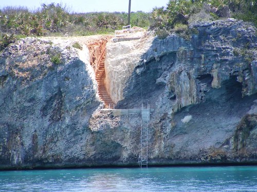
Stone carved staircase
The highest western side cliffs are more toward the northern end of the island. As we moved more southerly, the rocky cliffs gave way to some small, shallow beaches in little coves. Phoebes would fly out from the shore-side vegetation and land on our rigging. Then, they would hop up next to the mast light to look for insects that had been attracted to the light at night and eat them. Then they would poop on the deck, and their droppings were nothing but dried pieces of insect bodies. I could just sweep them up with a brush and dust pan.
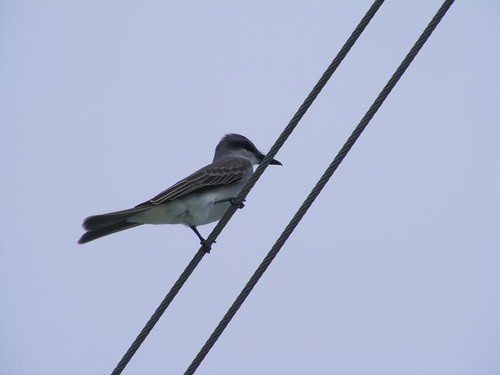
Feathered visitor
Since the light winds had a mostly northwestern element to them, we anchored in the north end of Alabaster Bay near Pelican Cay. The chart indicated the area had poor holding, but the south end of the bay has a hard bottom, so that is just as bad. We got the anchor to set well enough, or so we thought. Eddie dove it and swam out to look at the anchor; it had dragged across the bottom and hung up on a grass ledge. Since we had put out 200' of chain we knew we would also get some holding from that. Even though winds and seas were very light, our stern was facing the beach, and we don't feel comfortable about that. It feels like being trapped. Another power cruising boat that had been anchored at the south end came up and anchored near us, thinking we had better holding. Bad assumption. There was a pretty sunset, giving hope that the weather would stay decent.
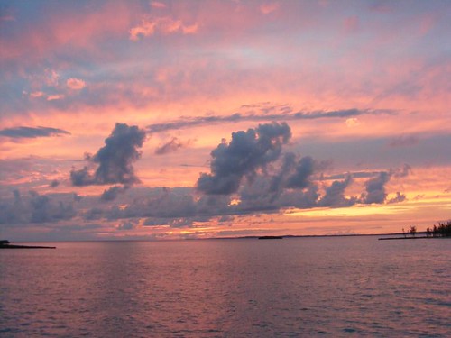
Almost the last sunset
Storm clouds moved into the area by 10:00 p.m., and the waves started kicking up a bit and FLUKE started bouncing around. I got up at 11:00, and Wayne followed shortly thereafter to make sure that our anchor was holding and to check the radar for what may lay ahead. The wind continued to strengthen and the seas built higher and higher. White rollers were hitting us on the bow and side depending on how we swung on the anchor. It was just like being at sea: Visitor threw up, stuff banged in the cabinets and fell off the shelves.
At around 1:00 a.m., the boat next to us starting dragging anchor and had to move. I felt so sorry for them as I watched them try to pull in their dinghy so its line wouldn't get caught in the prop and then have to shine their spot light on the foredeck to be able to see to try to bring in the anchor while their boat was hobby horsing violently. The guy was on his hands and knees trying to get to his bow, and I just kept hoping I could continue to see him on the deck and not overboard. Once they were underway, Wayne called them on the radio to ask what they planned to do at that point and tell them that we were still holding, although we sure felt scared and uncomfortable. They ended up going back to the south end of the bay and it took over an hour for them to get down their anchor again.
By the time the winds and seas died back down to a more reasonable level that we felt safer with, it was 4:00 a.m. We all laid down to try to get some sleep. However, I woke up at 6:45 when I heard the wind picking up again and the boat beginning to move more. I looked outside and saw storm clouds closing in. I woke up the guys and told them we needed to get the anchor up ASAP and get underway and get out in more open water where we could have better control of the boat.
We had a five hour run to Rock Sound, where we were optimistic that we would find calmer conditions for the upcoming stormy weather. I had plenty of time to remember why we had never cruised in Eleuthera before.


Whew! Tense!
ReplyDeleteJerry
Thank you for your writing and photographs! I'll never be able to cruise, except vicariously, looking at your blog. Please keep on adding more of your travels.
ReplyDeleteJim