June 18 – 19, 2012
After we departed from Big Majors we decided to go visit the Exumas Land and Sea Park as it had been quite a few years since our last visit. The ELSP covers the area of 15 big cays, 22 miles in length by 8 miles in width, from Wax Cay cut on the north end to Conch Cay cut on the south end. There are no commercial developments within the park boundaries, but there are a few cays that have private homes on them. The entire area of the park is a no take zone: no fishing, no shelling, no removing anything living or dead. As far as the underwater life goes, the ELSP is a great place to be able to see the animals in their natural habitat where they have had the opportunity to live unmolested by humans. As a result, the species abundance is greater and the animals as a whole don't exhibit the same skittish fear as those in the areas where they are hunted on a daily basis.
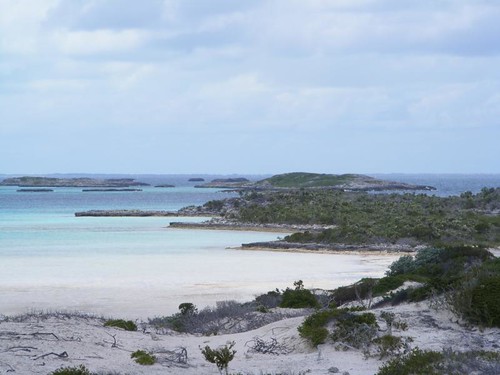
By lunchtime, we were fully secure on a mooring ball in the Emerald Rock anchorage, off of Warderick Wells, the cay where the park headquarters is located. This choice of location was based on the weather forecast of strong easterly winds.
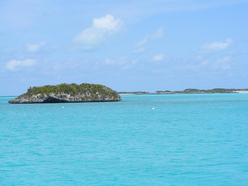
Emerald Rock
There are several scattered coral heads in the area, and I was looking forward to snorkeling on those heads and around Emerald Rock. Several different species of birds were nesting on Emerald Rock, so there was a lot of bird noise and activity within ear shot of our mooring – my kind of neighborhood on the western side. The white balls in the water are some of the other mooring balls.
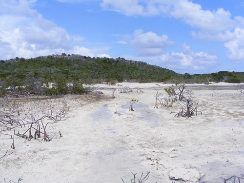
However, the picture on the eastern side, the elevated land of Warderwick Wells was another story. As soon as we got close to the land I remarked to Wayne “something really bad has happened here”.
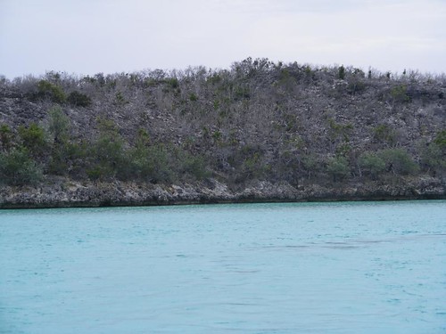
Where have all the flowers gone
With all the rain that the islands has been getting, I've told you many times how green and lush the landscape has appeared everywhere we have stopped. I think that this is the greenest I have ever seen the out islands. I've remarked how dense the undergrowth is when we have been on a land hike and have told you how we wouldn't have been able to walk anywhere if someone else hadn't already cut a trail. In the above picture, there is very little green vegetation remaining, and what you see is mostly dead sticks of shrubs and small trees. Even the contrast to nearby little Emerald Rock is apparent in the photos. I had a hunch what had happened and that was confirmed when we dinghied into the park headquarters after lunch.
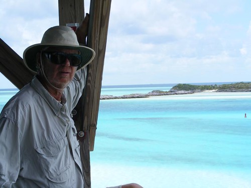
Eddie enjoying the view
If you have never been to the ELSP before, you should at least stop at the park headquarters to get an overview, literally and figuratively, of what the park has to offer. You can pick up all kinds of useful nature guides, historical books, tee shirts, and “souvenirs” that are all reflective of the park and out island life. It is not tacky tourist stuff! There are bones, shells, and preserved specimens on display that are relevant to what you can expect to see as you explore the park. Plus, there are staff members present that can answer questions you may have. You probably won't be surprised when I tell you that I had a written list of questions so that I would remember everything I wanted to ask. I know you are laughing at me now!
In addition, the headquarters building is elevated on a prominent point, so it gives you a good view of the main mooring field and the elevated lands to the north and south. There is a huge wrap around porch, and you will be tempted just to sit out there in the comforting breeze and enjoy the breathtaking views in all directions. I've had a difficult time trying to decide what pictures to post.

The main mooring field
When you see a picture of ELSP, you will probably see a scene like this one. It is usually the first choice area to get a mooring so that you can be near headquarters and be safely secured in this beautiful setting, where the current rips through the narrow channel at every tide turn. We stayed here during our first visit to the park. After you stay here though, you should not miss exploring other areas of the park because they are all unique in their own special way. It may be difficult to choose a favorite spot.
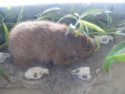
The destroyer
This nocturnal, rodent-like animal is a hutia (a preserved specimen). You can also see some skulls and chewing teeth in the display. I think they look like a giant brown guinea pig. The hutias were endemic to the Bahamas, but their population was reduced to only a small number on the Plana Cays, a tiny set of very isolated islands way south. The people in charge at the time (early 70s) were concerned that the hutia would be a lost species, and decided to relocate several breeding pairs to Wax Cay and Warderick Wells, where there were no natural predators. The hutias flourished, and unlike some mammal species whose populations don't respond well to crowded conditions, the hutias have just kept on increasing in numbers eating the island vegetation bare. In a balanced system, the hutias would typically eat undergrowth and lower parts of the plants, and the vegetation could continue to keep growing and reproduce itself. What has happened now is that the hutias ate everything low and even the upper levels of vegetation, including the growing tips. They have even stripped bark. The native plants are being wiped out and cannot reproduce. The hutias were put on a protected species list, so there is all kinds of controversy involved now as to how to solve the population explosion on Warderwick Wells. Well, the problem will be solved when there isn't anything left to eat.
If you look in the mooring field photo, to the right, you can see an elevated hill called Boo Boo Hill. You can hike there from park headquarters and at 70' high, you can get a great view of the surrounding lands and seas. We had brought Ursa in to hike with us, but found out that dogs are now restricted to staying on the beaches only. They might harm the native animal populations. Yes, it wouldn't matter about the hutias, but there are a lot of rock and ground nesting birds. Wayne said he would stay at the beach pavilion with Ursa while Eddie and I hiked over to Boo Boo Hill.
Thanks for low tide
It was just lucky coincidence that we were making the trek on low tide. This photo shows the lowest area you have to cross to get over to BBH, and at higher tides, it's underwater. You can see the red mangroves sticking up out of the sand and even some standing water. We had worn our sneakers, so I didn't want to get them wet and have the sand stick all over them when we got to the hilly portion of the trail. A portion of the trail goes over solid, sharp rock with lots of holes, where you need to really watch your footing, so you have to wear safe shoes. I could see hutia footprints and scattered poop all along the trail.
Legend has it that Boo Boo Hill got its name because some islanders said that you could hear the cries from the ghosts of a group of missionaries that had shipwrecked on the island years ago. Now it is the destination of most all cruisers visiting the park, and the sounds you hear are those of laughter and glee and oohs and aahs as visitors look at the 360 degree awe-inspiring views.
So many cays, too little time
While the main theme throughout the park is “Take all the pictures you want, but leave only footprints”, the one spot where they have made a concession to every visitor's need to leave his or her mark, is on Boo Boo Hill. You can add a piece of driftwood, painted or carved, with your name on it. Most visitors have the name of their boat and a date on it. Some people go to great lengths to make pretty, elaborate signs ahead of time, knowing that they will be making this wonderful hike. The pile grows enormous until it is all blown away by a hurricane, and then it grows again.
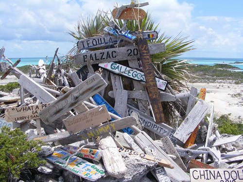
Leave your name on Boo Boo Hill
The eastern side has the Atlantic Ocean crashing into a rocky shore, where there are several blow holes that can shoot mists up very high if there is a strong onshore blow. At this time of year, the tropic birds are nesting in the rock holes in the cliffs and you can watch the graceful birds, always flying in pairs, with their beautiful long tails sailing on the winds down to the water in search of food.
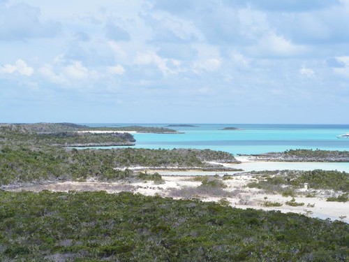
Looking towards our neighborhood
This is the southern view, where we are moored, but the land obscures the view of FLUKE. If you look far to the right you can see one of the mini megayachts secured on a mooring. The park supplies safe moorings for yachts up to 150' in length. There is some room to anchor out on your own hook, but at $20/night the moorings are a good way for us to help support ELSP. The moorings are designed to allow a lot of vessels to occupy more space and preserve the sea bottom.
Before we left headquarters we signed up for the WiFi service. The park is generous to share its precious two way satellite connection with cruisers, so the connection is slow and there are restrictions (no internet telephony, no audio or video sites permitted). The fee is $10/day, limited to 24 hrs or 100 MB, whichever comes first, and only 1 hookup/vessel. The paper you are given says “If you think the network connection is too slow, take a look around you and enjoy the scenery and the setting...after a long look at the different shades of blue water, the sandy beaches, and the beauty of the park, your page should be back up and ready for you to try again.” I would add, if you REALLY NEED it at all!
When we got back to FLUKE it was still early enough and the sun was out, so I wanted to snorkel the coral heads near our mooring and around Emerald Rock. I told the guys I was taking the dinghy and would be off on a snorkel expedition. Eddie started whining that he wanted to go, but needed another day for his ear “issue” and begged me to wait until the next day so he could go with me. I relented and just ended up swimming to the rocks near shore and then back to FLUKE to work on continuing to scrape the growth off the bottom until the current got so strong I couldn't stick close to the boat without a lot of effort.
The next day it rained all day! The moral of this part of the story is “Snorkel while the sun shines”. I watched a group of young people from a charter boat try going out to the coral heads in the pouring rain to snorkel, but they didn't stay long and came back and just jumped off their boat and played in the water until they got too cold.
I had made a plan for the day that I wasn't going to give up, like yesterday's lost snorkel opportunity. I had decided to go ashore right before dark in hopes of seeing a hutia. Even though it was still raining, I asked Wayne to drop me off at Rendezvous Beach where I planned to take one of the trails up into the bush to look for the hutias.
Warderwick Wells has many well-marked trails, the most on any of the islands. I scrambled up the steep, rocky sloped Davis Plantation Trail that shortly led to a site with Loyalist ruins from the late 1700s.
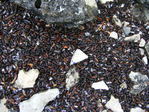
Poop and pottery
I was shocked by the density of hutia feces. The amount that you see in the photo wasn't an area that was just a collection site. The ground was covered like that everywhere. I can't imagine how many hutias it took to make that huge amount or maybe the feces just don't decompose very fast. You can see two pieces of pottery, artifacts from the Loyalist settlement. There are stone and mortar ruins nearby. With all the vegetation stripped from the hillside, I could see a great distance. No hutias were in sight, maybe I was too early or else they didn't want to come out of their holes and crevices in the rain.
We couldn't stay another day in the park and risk losing a good weather window to make the open ocean crossing back to the Abacos. I know there are hutias in those hills and lots of fish in the emerald sea that are waiting for me. Warderwick Wells will have to be on my list again for a future visit.


awesome pictures in your last few posts, especially of the water. Although I didn't really need to see the poop:)
ReplyDeleteAl
Certainly can see why selecting photos is time consuming! "Too many cays, too little time" is splendid!!
ReplyDeleteIs there a sign that specifies 'hutia poop'? Many pics of that to choose from too? I know; you're showing the pottery! Of course! LOL
Boo boo hill and hutias - so many surprises - always an adventure!
ReplyDeleteThanks for lettin' me tag along!
Jerry