After a peaceful night at the anchorage in Wrightsville Beach, we exited the inlet to make the 8 hr. run to Beaufort, NC. We decided to go back to sea rather than take the inland Intracoastal Waterway route because the ICW through that stretch of the waterway is plagued with shoaling, low bridges we would have to wait for, narrow, and lots of traffic. The seas were borderline comfortable, but no one got sick. It was the first day we didn't sweat from the heat since we left Florida,and that was a relief!
We entered the inlet with the winds behind us and outgoing tide which always is a formula for more turbulence than cruisers would like to have. Fortunately the Beaufort inlet is a Class A inlet with a deep channel, wide, and well-marked.
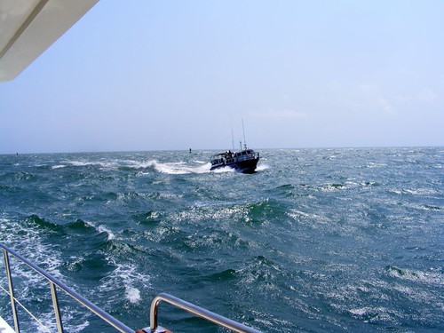
Rough Ride Through the Inlet
We headed toward the ICW after we exited the inlet area and planned to stay on the ICW for a couple of days until we would stop at Great Bridge, VA. Our other alternative would have been to continue traveling out in the Atlantic, but we would have had to round Cape Hatteras (a long way out) with the weather deteriorating, and the next section of the ICW is mostly pleasant and easy to travel on.
Before we could even get on the ICW we needed to go through the bridge in the photo that was being blocked by the shrimp trawler, the Capt. Allison Milliken. We didn't mind waiting though, because we had the opportunity to watch a really skilled captain in action.
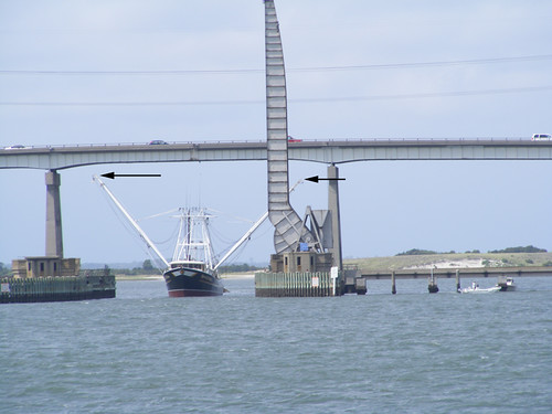
Raising the Outriggers
In order for the captain to get his boat under the bridge, he had to lower his outriggers, but he had to be careful not to lower them too much because they would hit the bridge supports. Once through the bridge he had to stop the boat before he reached the railroad bridge that was right next to the bridge he just went under so that he could get the outriggers back to their upright position so he could pass by the railroad bridge (seen vertical in the photo). To do this, he needed to be able to lay up on the bridge fenders where he could stop the boat to raise the outriggers. Just getting a big boat like that up against those fenders with an the outgoing tide pushing him and such limited space would have been a feat in itself. He got assistance in getting pushed over to the side with the little yellow towboat in the photo.
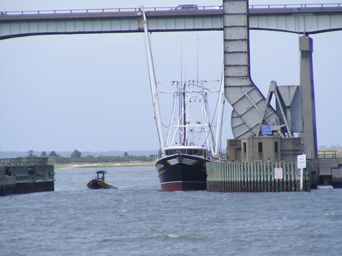
Laying Up Against the Bridge Fender
When the bridge area was clear, we moved onward. We would be traveling on a part of the ICW that originated from natural waterways connected by man-made canals, most of which are narrow, and go through back country land and swamps. I like smelling the pine fragrance in the sections bordered by the pine forests and looking for wildlife,of which we usually see a variety.
After a quiet night anchored in South River, across from Oriental, NC, we had the hook up and were underway by 0600. A cold front had passed through, and we were “chilly” most of the morning. It felt so good not to be sweltering. We made calls to a couple of people in Florida to tell them we were cold!It was such a clear, beautiful morning, and there were a lot of blue crab fisherman checking their traps in the shallow backwaters.
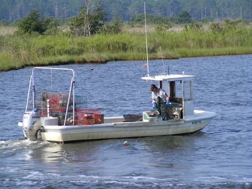
Fishing For North Carolina Blue Crabs
One of the most significant stretches of this section is the 21 mile long Alligator Pungo canal, so named because it connects the Alligator River with the Pungo River. The canal traverses some farm lands and a large portion of natural swampland. A lot of boaters find the canal an annoyance, mostly because it is very straight and narrow bordered by an enormous number of stumps, as well as dead and decaying trees that become dead heads, dangerous, mostly submerged floating logs. You have to keep a sharp eye out at all times so you don't run one over. One of those things could put a hole through the hull of the boat, bend the prop, or break a rudder. I only get nervous with the stumps when we have to pass a barge that is taking up most of the canal, forcing us over to one side. For all the stumps we can see, I just know there are many times that which we can't see.
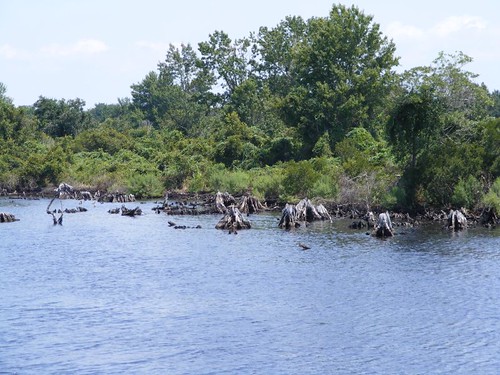
Dangerous Stumps
The canal usually has some wildlife to see, the most being present early or late in the day. Since we were traveling through in late afternoon there wasn't a lot of excitement. I did see two bald eagles, one adult and one juvenile and a pair of quails, any of which I haven't seen in the wild in over 20 years.
We had to pass a sailboat named ROCINANTE. The first challenge was deciding how to pronounce the name correctly to call on the VHF. I am always amazed why someone chooses to name their boat something that the majority of the boating population cannot say or spell correctly. The captain was excited I said the name correctly and became very chatty. The name was taken after the mule of Don Quixote, a trusty steed that would take him any where he wanted to go. That is a glamorous name compared to the Sea Ray that also passed us named A LOT OF NUTS AND SCREWS. I could devote the rest of the blog to my theories about that name, especially being a Sea Ray, but I will only let you speculate on your own. Plus my Mom gets a copy of this and gets upset when I use foul language.
Alligator River Single Pivot Swing Bridge
You can see in the photo that this is a very long (about 2 mi.) low, bridge. The bridge tender actually drives his car out to the keeper's house, where a designated car park area was constructed. We think this is the only bridge we have seen where this has been done. While the bridge opens on demand, if the winds exceed 34 KTS it will not open. It has a huge tooth and gear mechanism that supports the moving span, but the span is so wide it must not be stable enough to sustain high winds. Once passing through the bridge we anchored for the night near the mouth of East Lake, just a remote, wooded area with gobs of crab traps in the water.
Most of the next day was rather uneventful as far as natural scenery goes. Since it was Saturday, all kinds, mostly crazy, of weekend boaters were out in full force as we transversed Currituck Sound. It appears that the latest rage on the water is being towed by anything from a slalom ski, requiring some level of skill and dexterity, to a gigantic 4-person rubber couch like thing that you just sit on, hardly getting wet, until it capsizes. That undoubtedly must be the toy of future couch potatoes.
Shortly over the VA border we were coming up to the North Landing bridge, trying to time our approach for the hour or half hour opening, when we heard the bridge tender talking to an approaching tug. He asked the tug to lay back a bit because he was having trouble with one of the bridge spans and needed to “put some water on it” in hopes of getting it to open properly.
North Landing Double Pivot Swing Bridge
When it was our turn to go through the bridge, the tender called us to ask us to pass through with only the left span (look at the photo) open because he was having trouble with the right one. We didn't think we could fit through the opening, so Wayne called the tender to ask him how wide it was. The full width, with both spans open, was 40', and we have a 18.5' wide beam, so it was going to be an unpleasant squeeze. The tender said he would open the right span a bit, which gave us room enough to pass through without scraping the fiberglass.
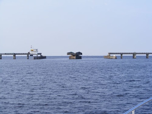
5 miles later we had to pass through the Centerville Turnpike bridge. It too, is a low bridge with a vertical clearance of only 4' so it has to open for even the smallest of boats. Over 16,000 cars/day use the bridge, yet for some reason, it opens on demand on the weekends for boating traffic. Two barges, us, another big motoryacht and a couple of small boats all wanted to get through, so the tender waited until we were all piled up together to minimize the time the road traffic would have to wait. The wait forced us into having to pass the first tug in a “skinny” area of the waterway, where we had to move over with less than 2' of water under us.

Passing Two Scrap Barges Very Closely
We were on the working channel for the bridge, which is the same channel the barges use and overhead an interesting conversation between the two scrap tugs. Tug 2 called tug 1 to ask him how fast he was moving so tug 2 could gauge his speed to keep up with tug 1 to make the bridge openings together. Tug 2 said his company had restricted him to using 60 gals. of fuel/hr. to reduce operating costs. Tug 1 said his company had done the same thing with him. Tug 2 said at the current rate he had been traveling to keep up with Tug 1, he was burning 70 gals/hr., but he would justify the overage by having to make the bridges. As a comparison, we have been burning about 3 gal./hr.
Speaking of diesel fuel, just after we passed through the Centerville bridge we pulled into Atlantic Yacht, adjacent to the Great Bridge in Chesapeake, VA, to top off our fuel tanks. We still had 700 gals, but we added another 300 in hopes of not having to purchase fuel again until we are in this area for the return trip. We only paid $1.97/gal., and the prices of fuel are always much higher in the northeast. Plus, we topped off our water tanks, including filling the washing machine, so I did a load of laundry.
So here I write, docked at the free dock at Great Bridge Park, one of our favorite stops on the whole east coast. The WE Marine Maintenance Team are dissecting the hydraulic oil pump for the auto pilot in hopes of trying to figure out why AP is not doing his job properly. It may be a few days before I can give you the results of that operation since we will have to hand steer once leave here anyway, and AP won't get the full test until we are in some wide open waters.
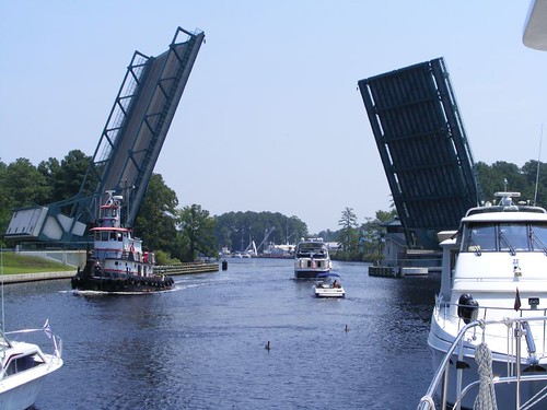
The Twin Bascule Great Bridge Bridge
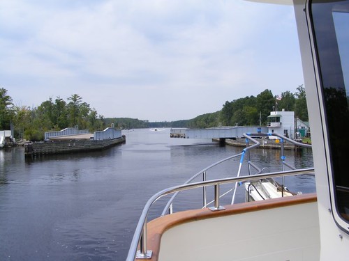
Great Bridge Park is comprised of the area between the Great Bridge lock and the Great Bridge bridge, maybe about ¼ mile apart, and that portion of the ICW in between. There is a small strip of land on either side of the waterway that is mowed and landscaped. Near the lock end is a well-treed park with playground, boat ramp, picnic tables, etc. You can watch boats, recreational and commercial, lock through the lock and then watch them go through the Great Bridge bridge, one of the most beautiful bridges we have seen. The shore is so close you can easily talk to the people on the boats. A lot of people fish and crab (the couple right across the waterway from my window have gotten at least 10 blue crabs in the last 30 minutes-I could get into doing that!) along the bulkheaded area between the two structures. Other people just sit and watch the waterway traffic pass by; the lock and bridge open on the hour and there is always some activity, especially when barges have to pass each other.
This is a great stop for cruising boats, not just because we can dock on the bulkhead for free, but also because all kinds of stores and restaurants are within easy walking distance. We stop here, if for nothing else, but just to go to Dairy Queen, every cruisers dream.
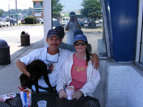
The FLUKE Crew At DQ
Today, August 9, it's 100º, and is supposed to be the same tomorrow. Our DQ treats were melting quickly. It was a hot walk to the closest mailbox and bait and tackle shop. We detoured through a residential area to be able to walk in the shade of the huge pine trees. Despite the extreme temperatures, these people have the Fall spirit already. Tomorrow we'll be moving northward, hopefully to cooler waters.
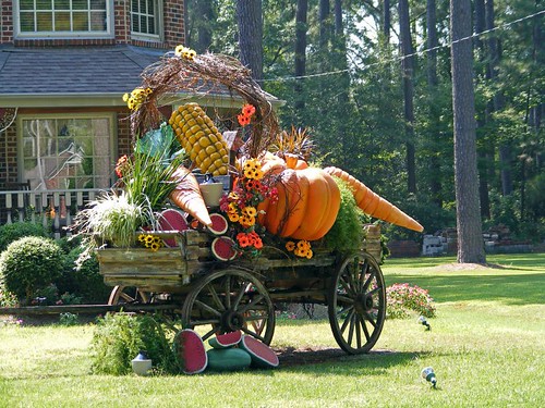
Bountiful Yard Art


Woooeee! Those bridges sure look like a hassle!
ReplyDeleteI'm so happy to see photos again! More of Ursa though.... :)
ReplyDelete