Learning As We Go
Well, Henry gave us a great cruise up the Hudson, but it was time to “branch” out our adventure and turn west up the Erie Canal. While it was only about 65 miles from Kingston to where we would leave the Hudson to head up into the Erie Canal, we had to divide the trip into 2 days to get FLUKE prepared for the Canal transit. FLUKE had been that way before with her previous owner so we knew we could do it.
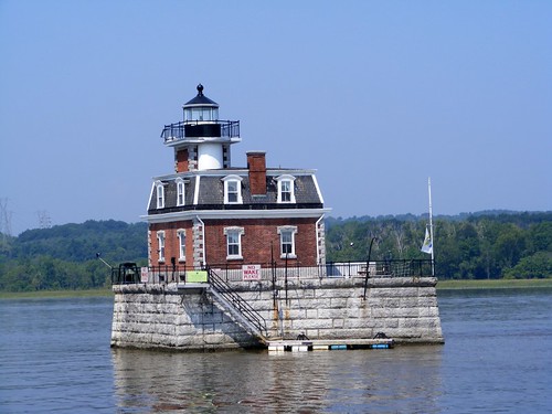
In the short distance we passed two premier lighthouses. The Saugerties Lighthouse, 1869, sits on a tiny peninsula jutting out into the river. Its upkeep is partially financed by being run as a bed and breakfast. So, if your life list includes sleeping in a beautiful lighthouse, schedule a visit. That sure would be a great surprise for your sweetie!
Saugerties Lighthouse
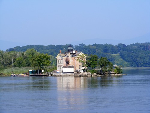
Not too far away, but well out of earshot, is the picturesque Hudson-Athens Lighthouse, 1874. Its present day claim to fame among the lighthouse crowd is that is has one of the last working fog bell mechanisms in the U.S.
Hudson-Athens Lighthouse
Not all the sights were as nostalgic as the lighthouses. America must keep on building, and the rivers serve as a great corridor for moving materials or the fuels needed to run the plants that make the goods. Even this far up the river we have continued to pass several loaded tugs. Hopefully the gravel barge being loaded in this photo will be more evenly balanced when it is completely full.
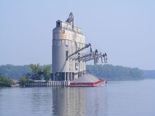
Better Than Shoveling By Hand
At midday on August 17 we pulled into Schodack Creek, south of Albany, to anchor and make FLUKE canal ready. Schodack Creek is a dead end spur off the Hudson. Since it doesn't have any through traffic we knew we wouldn't have to worry about having other boats wake us. It took us two tries to get the anchor to set properly; the bottom just wouldn't get a good grip. Since the creek isn't very wide, we had to make sure we were right out in the middle, and were limited to putting out only 100' of anchor chain. More than that might have caused us to swing too close to one of the shores when the tide changed, and there is no telling what might be lurking in the shallows closer to the shores. Getting hung up on a big log in some backwater creek wasn't on our agenda.
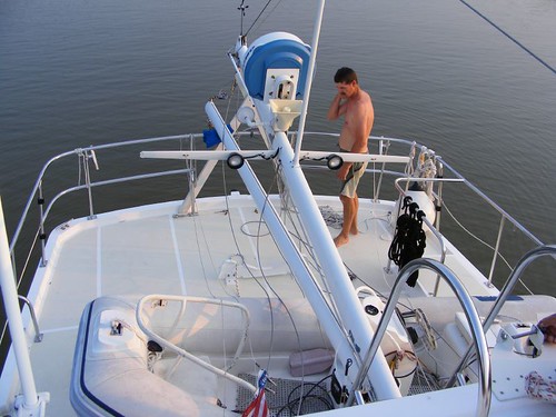
Number one on the list was to lower the mast. We had to do this because our height with the mast up is 34', and the lowest bridge we planned to go under is 20'. When we lower the mast, we will be 17 ½', or so we hope. We also hope that there will be no major flooding to where the water level gets raised enough to put us over the lower bridge limit, since we don't have much margin for error.
The WEMMT had practiced lowering the mast at the home dock a couple of times, so were familiar with what was required. However, the dry run was done with the dinghy off the boat, and this time, not only would the dinghy have to remain on the boat, it would have to be rotated 90° onto temporary chalks. I hope you can see why we didn't want any boat wakes during this operation. I expected to hear some yells and squeals, but the guys pulled the whole job off with minimal voice raising and no runs to the head. Even FLUKE was unscathed and adjusted fine to carrying her reconfigured weight once we transferred fuel from one tank to another to try to level her off.
What Do We Do Next?
The creek area was very quiet, other than when the commuter train went roaring by. Wayne said at least it didn't blow its horn, but it is right next to the creek, close enough that if you knew sign language you could communicate with people on the train. At least I was rewarded with an interesting wildlife moment early the next morning. I saw a gigantic (it had to be at least 30# ) snapping turtle lumbering along the muddy shoreline at low tide. It was trying to climb up the embankment and finally pulled itself up by clawing hold of some low lying branches. It looked like some kind of miniature dinosaur.
FLUKE certainly doesn't look as grand with her mast down; someone may even think we had some sort of accident, but up in these parts, that is THE LOOK amongst the taller boats. Radars, satellite TV dishes, VHF antennae, and any other pieces of equipment that gets your boat too high has to be lowered. You should see the sailboats carrying their masts, extending from bow to stern flat down the entire middle of the boat. Some of those cruisers have a hard time seeing over the whole thing, and don't have much room to move around their decks or in their cockpits. BUT, all will agree it is worth the extra work to make the trip.
The river wasn't very busy as we approached Albany, and the waterfront area is not picturesque to say the least. It is strictly an industrial area: scrap yards, fuel storage depots, product terminals, freight docks, and numerous abandoned buildings of dead industries. There are no modern city buildings or residential units directly on the riverfront. The big freighter in this photo caught my attention for obvious reasons.
FLUKE'S Distant Relative?
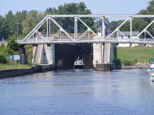
Troy, not far up river from Albany, was the site for our first lock, where we would go up 15'. In general, the locks have been built where once upon a time existed a waterfall created by a change in the elevation of the land. Ships couldn't navigate the falls, so the locks were built as a bypass to the falls. The falls may have been converted into a dam to function as a riverside power plant and to control the water flow in the river and help the lock to function.
The Troy lock opens on the hour and half hour, so it is worth it to time your arrival so you don't have to hover outside the lock. You have to call the lock tender and indicate what direction you are traveling and get clearance to enter the lock. Once you enter the lock you have to get your boat secured by putting one of your lines around a pipe or cable affixed to the side of the lock wall or holding the boat in place with lines that are hanging into the lock, if the lock provides them. The whole point is to make sure you have your boat held tight so that it doesn't get pushed into the slimy and rough sides of the lock when the water is filling or emptying the lock, causing your boat to want to move around. Most people think that the water enters the lock by flowing in through the big gates that seal off the ends of the lock. That is not the case, thank goodness, or it would be easy to be really swept away. The water enters the lock basin from down below the surface, close to the gates, thus minimizing the turbulence.
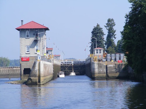
Locking Up 15' At Troy
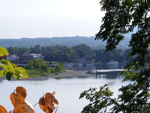
About 2 miles later we saw this sign, so it was time to leave the Hudson and begin our journey on the Erie Canal, fed by the waters of the Mohawk River.
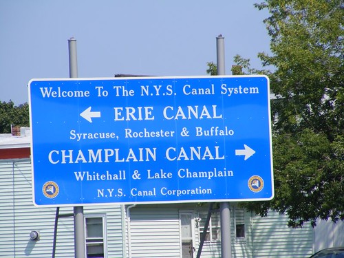
Which Way To Go
The Erie Canal extends all the way to Buffalo, on Lake Erie. However, we can not take the canal all the way over there because there are bridges that are lower than the 20' clearance we can reasonably accommodate. However, we could still get to Lake Erie if we traveled up into Lake Ontario and took another canal system. With our late arrival to these parts we will not even enter Lake Ontario, accessed from the Erie Canal by the Oswego Canal. We may get to Oswego, but we are really winging it at this point with our motto being “We don't have a schedule and we're sticking to it”. We are just going to take it easy, see the sights, and move when we feel like it. It is a great feeling not to have to worry about Hurricane Boat Anxiety. HBA is truly a dreaded malady suffered by all boat owners in Florida during the summer months, but we will be safe from it up here.
Life At An Intersection
Pointed Westbound
FLUKE is the boat at the far right, just beyond the bridge. We have been docked at the Waterford Harbor Visitors Center since arriving here on August 18, and today is the 25th. So, we have set another new record: this is the longest period we have ever been at a dock! There are several good reasons why we have stayed here for so long.
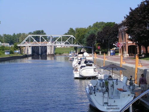
Our Waterford Homesite
The Visitors Center is a wonderful facility designed to attract cruising boats. There are floating docks that supply water and electric service for free for the first two nights, and then it is only $10/day after that. There is an information center, newly opened, that is staffed by volunteers who pleasantly answer questions and try to be helpful. The grounds are beautiful. Paver bricks, depicting the entire length of the Hudson River and the canals that branch off of it, with the locks and major cities, line the walkway parallel to the waterfront. It is fun to walk along and see where we've been, where we want to go, and even the areas we won't be visiting. There are tables where boaters can get together for cocktail hour to exchange boating stories and information Yesterday I discovered that there is a live web cam, and you may be able to see us walking around if we are still here, or watch a boat lock through, when you access the site at: http://town.waterford.ny.us/video_clips.htm. On Sundays during the summer months a Farmers Market, with a live band, gets set up right along the waterfront. The produce is locally grown on the small farms close by. It is so fresh; one of the vendors sold out of corn, so she sent her husband back to the cornfield to pick more to bring back to the market.
Floating Free Again
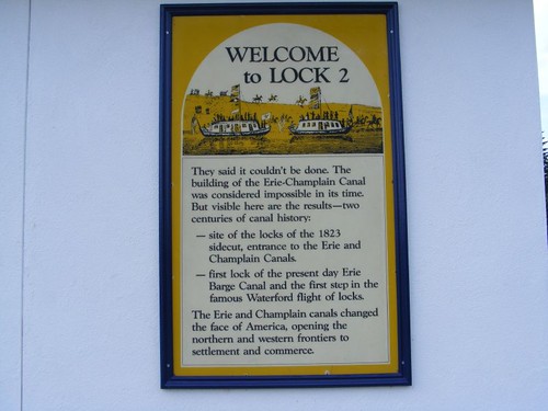
There is always a bustle of activity since the VC is adjacent to Lock 2, the first of five locks that lift boats up a total of 170', in the span of only 1.5 miles, to get to the Mohawk River. It is fun to watch boats lock through, and you never know what kind or size of boat may be using the lock. We have seen boats that are put in the river on trailers and we have seen barges go through that take up the entire width and length of the lock, obviously constructed with those limitations in mind. There is a fleet of these charming, easy to operate, canal boats that you can rent to cruise the canals, styled after those you might see in Europe.
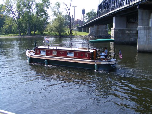
A Real Canal Boat
Local residents come down to the waterfront to walk and watch the locks and boats. We have people stop and ask us questions about FLUKE and our travels. Everyone laughs after they ask us where we're going and we point at the lock and say “that way”. Fishing is a popular past time for the locals, and they use the lock area bulkheads and nearby river banks from sunrise to sunset. It is fun seeing what people catch and seeing how passionate they are about the sport, despite having to release anything they catch. These signs are posted anywhere around here where people may be fishing.
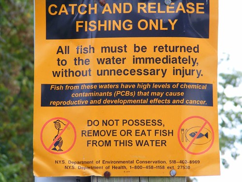
Learning To Read English IS Important
The PCB contamination is mostly associated with a GE factory up river which discharged large quantities of contaminated water before it was discovered how dangerous the polychlorinated biphenyls were and how they concentrated in the food chain. Years passed before someone decided that the river bottom should be dredged down to the contaminated layer to remove the toxic material. So now, for the last 10 years, the river is being dredged, stirring up the contaminated layer into the water as they remove it. A volunteer lady at the Visitors Center said her son has worked on the project for 10 years and thinks it will take another 10 years to finish. Then they are talking about finding other areas down stream from the initial site that may need to be cleaned up. That will all probably depend on what political climate exists at the time a decision has to be made, and how much tax payer money is available for a stimulus.
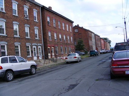
Waterford, founded in 1794, is the oldest continuously incorporated village in America. We have enjoyed walking from the waterfront to the main street, seeing old public buildings and private residences, many of which are multifamily dwellings of various sorts. Like many of these old towns in the northeast where livelihoods were originally dependent upon mill industries which have now long been shut down, Waterford struggles to keep going. The main street, the old downtown area, has a difficult time keeping the stores rented, and hasn't been able to get an artist or boutique business basis in place since Waterford is not a destination town for land travelers. Troy, is located right on the other side of the Hudson River, and we can walk over there to shop at chain grocery stores.
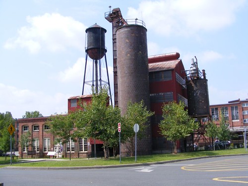
Factory Powerhouse
We can walk over the dark bridge (old railroad bridge, now a pedestrian walkway) you see in the earlier photo to go to Peebles Island State Park. In 1909 Cluett, Peabody & Co. bought the land for a factory that bleached cloth to be used for mens shirts (the Arrow shirt) and collars. The process of sanforization, or preshrinking fabric, was developed at the factory. It was a convenient site because the railroad ran right through the property and the nearby river had water readily available for power use, transportation, and waste discharge. The factory operated until 1972, and then the 191 acres of land was purchased by the state.
Part of the old factory powerhouse building houses the Peebles Island State Park Visitors Center. You can look at an old steam generating system, see displays on the natural history of the island, and displays on the industrial history of the surrounding towns and places of interest. Another part of the old factory buildings houses the Peebles Island Resource Center which evaluates artifacts for their historical significance and develops preservation programs for historic properties.
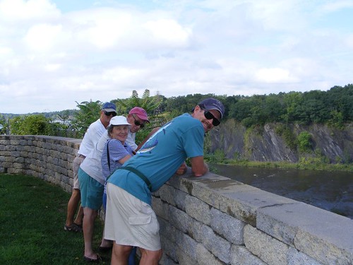
Hiking the trails around the island is popular for locals and visitors. There are several prominent bluffs that overlook branches of the Mohawk River and its associated water control dams. We saw deer and lots of bird life.
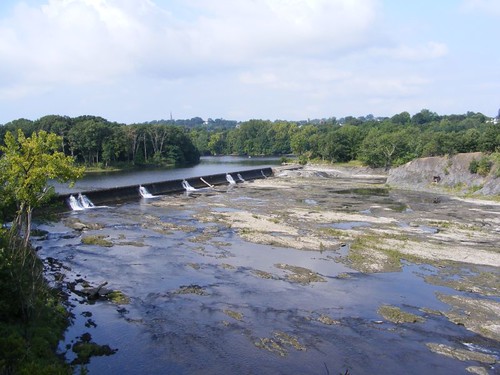
Branch Dam
There are still natural cataracts that haven't been dammed, and they can provide some family fun, if you want to break the no swimming rules of the park like this family (see arrow in photo below) has chosen to do. Older locals tell stories about all the fun and excitement of cascading into the river from its inlets and over the cataracts. Now-a-days, no one can assume liability for such “dangerous” activities where an accident could lead to trying to lay the blame on someone else via litigation.
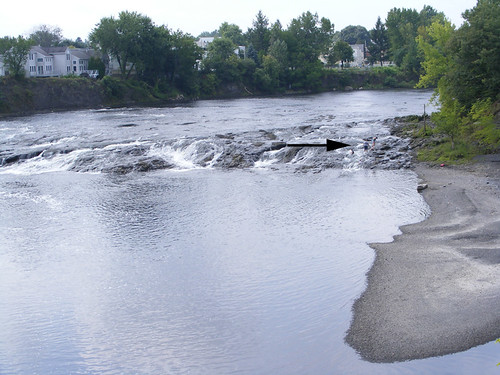
Peebles Island Cataract
There are numerous trails, for walking and biking, along the locks and along the original parts of the Champlain and Erie canals that transversed this area. The trails were originally used for pulling the barges along the canals using mules. There are shoe prints and barefoot prints in the cement along the Visitors Center waterfront depicting this work. We have walked a lot of the trails, and one night I saw my first muskrat swimming in the canal. After a torrential downpour, which caused a lot of erosion, I found an old spike, from whose knows what, but I call it my “artifact”. You can walk or drive right up to the locks themselves and talk to the lock operators; the two we spoke with were so friendly and they answered many questions. One of them even opened up the coverings housing the main motors and electrical system to explain how they were meticulously maintained and how the lock worked. They still use electrical panel equipment from 1915, 250V DC. It looks as new as the day it was installed The operator showed us his scars from where a spark arced from the panel and burned him, but that only happened once!
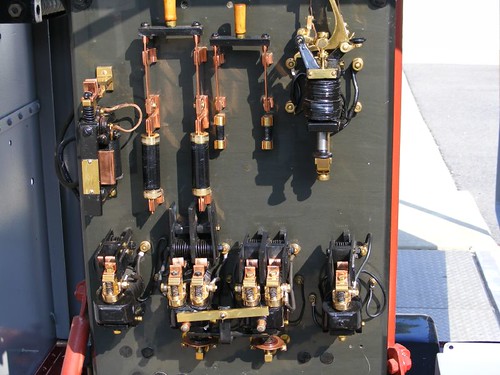
1915 Still Operating Electric Panal
It is fun to stand right next to the empty lock and look way down and see boats enter the lock and tie themselves up. Then the gates slowly close and the water swirls in eddies, filling quickly from the bottom, all 3 1/2 million gallons at a time, even for this little pontoon boat in the photo. The water has to fill all the way up to the top of the dark line. Transiting the locks isn't free. Our season pass cost $100 and is good for all the locks and the entire time they are open,depending on the weather, but generally May – November.
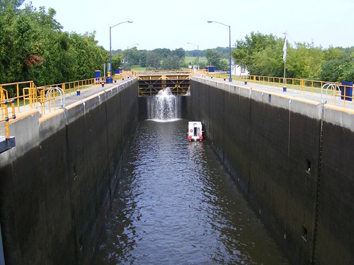
Needing a Lift
Walking on the trails on Peebles Island you can look across the Mohawk in a couple of places and see parts of the town of Cohoes. A prominent structure is one of the old gigantic Harmony Mill buildings. Harmony Mill was originally built in 1837 and became the largest and most technologically advanced cotton factory in the U.S. by the 1870s. The mill operation was successful for 61 years. During that time, Cohoes became a true mill town. 1 out of 4 of the 3100 residents worked at the mill. The mill constructed 700 tenement houses; in the early 1900s it cost 39 cents/week for rent. The housing was so well constructed many of the units are still being used today. The old mill building is on the National Historic Register and is being converted into luxury apartments, with gorgeous views of the Mohawk River and hills in the distance.
Factory Houses
Part of the prominence of Harmony Mills was due to Cohoes Falls. It is the largest waterfall east of Niagra Falls, and it supplied the power for the mill machinery during the Industrial Revolution and still is a major source of hydroelectric power today. A visit to the falls is well worth the trip, less than 5 miles away from the Visitors Center. When my brother and sister-in-law visited we were able to get a ride over to the falls.
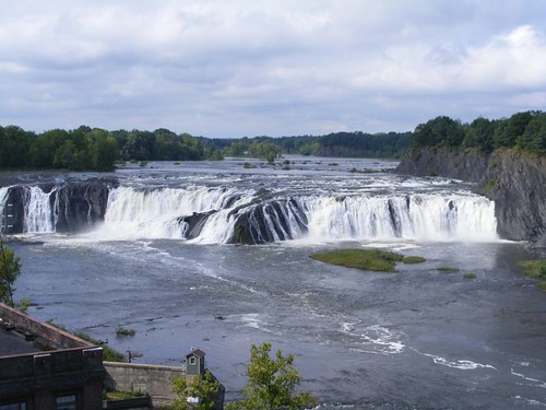
Cohoes Falls
One of the volunteers at the Visitors Center told me that under normal flow, water runs at 90,000 cubic feet/sec, but last May when it was at a flood stage 640,000 cubic feet/sec was flowing. That caused the Mohawk River to be in a rage. Lock 2, the one in front of us, couldn't open because the water around here was flowing too swiftly, and traffic couldn't move through. The docks at the Visitors Center floated above the bulkhead, and water was 4' high in the VC building. As we all stood there looking at Cohoes Falls we could imagine what the Falls and River looked like during the flood stage.
High Above The Mohawk
Talk of the day is that we will be leaving here tomorrow. I love it here, but am looking forward to seeing the other sights along the Erie Canal. I'll keep you posted.


0 comments:
Post a Comment