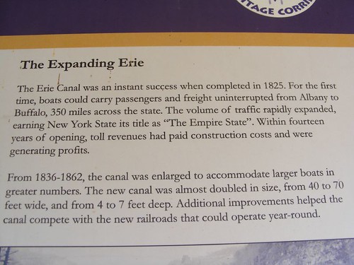
Erie Canal summary
As the title suggests, we are having just as good a time as when we cruised the Erie Canal in 2009. In some ways, it is more relaxing because this time we can try to do the things we weren't able to do back then for one reason or another.
I saw the information in the opening photo on one of the sign boards next to a lock we stopped at. Most all of the locks have some sort of kiosk with signs talking about aspects of life along the Erie Canal. A lot of them have old photos from the day when the Canal was booming, and it is interesting seeing the different canal vessels of that time. The only commercial vessel we've seen so far is the one that had to put its barge alone in Lock 2 at Waterford. I also wanted to add that the fee for FLUKE to pass through all the locks in the NYS Canal System as many times as we want this season is $100, which we think is a real bargain considering all the work that has to go into maintaining the locks and canals.
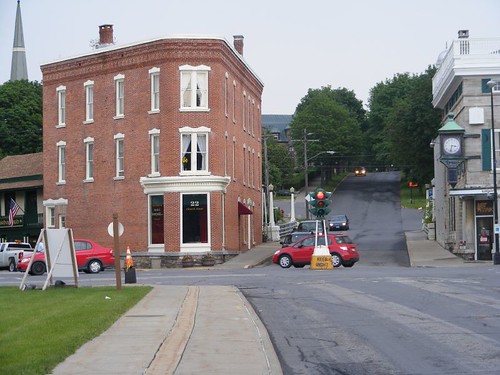
Canajoharie's major intersection
There might be one more intersection in the “downtown” area, which only extends for about a block. There are some architecturally fascinating buildings from the canal era days, but most are closed up; the town just hasn't been able to establish a drawing theme to its downtown area. The major industry was the Beech-Nut plant (started in 1891), but it closed in March to relocate about 12 miles away, leaving its behemoth factory behind.
The town tries to draw in recreational boaters by offering free dockage with electric at a nice canal front park. The town of Palatine Bridge is across the canal, where there are a number of shopping opportunities that would appeal to cruisers (grocery, laundry). It is also the site of an Amish community which provides seasonal produce and crafts.
Canajoharie is a Mohawk word meaning “The Pot That Washes Itself”. If you are a nature person, this should be on your list of places to stop so that you can walk a ways from downtown up the Canajoharie Creek along Floral Ave. and see how the name was derived. As the creek flows downhill, it has to go over a series of varying sized falls which causes the water to swirl and weave between different types of rocks. Some of the swirls get into softer sections of rock and make huge, open, perfectly round holes. When the water is low, you can walk right out in the creek bed and wade through the small holes or jump right into the big holes, like what the Indians thought of as a pot, but now people would call a spa or hot tub. It is a beautiful setting.
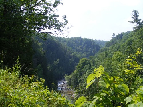
The creek gorge
If you are really motivated you can ride your bicycle all the way up to Wintergreen Park to see Canjoharie Creek gorge and the falls. That was what we did, not thinking about how really uphill it was going to be most of the way. In fact, the road was so steep in some places, we had to stop and walk our bikes. One section was so bad, Wayne took my bike because I had Ursa in the basket and it was extra hard to push uphill with my sore arm.
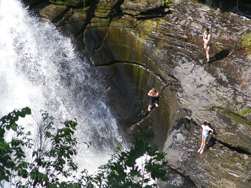
Pot jumpers
Once you get to the top there is a trail that leads to an overlook to view the largest of the creek falls. A gigantic “pot” has been created from the path of the water. In the photo you can see how very round it is. There were people jumping off the very slippery sides into the rushing water 30' below the rim of the pot. Some locals were on the observation platform looking over at the same time we were and said that jumping was prohibited because 4 people had been killed in recent years, mostly from slipping and not jumping out far enough and then hitting their heads. Helicopters have to air lift accident victims out of the gorge because it is too steep for any vehicles to get to the bottom. The people said that the kids who jump now come from Albany; all the local kids know how really dangerous it is. With the recent rains, the falls were really pounding over the edge, and we wondered how the jumpers kept from drowning. Once they landed in the water, they were swept away out of sight. Maybe that's why we only saw each of them jump once!
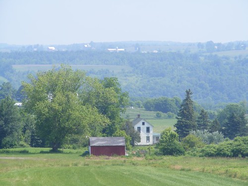
Pastoral countryside
The bike ride downhill was quite a thrill to say the least. We had to really watch for potholes and apply our breaks most of the way down. Fortunately we were able to look out over the countryside on the way up, because there was little opportunity to do so on the fast way down. I thought Ursa and I must look like a couple of cartoon characters speeding downhill with the wind in our faces and our hair flying out behind us!
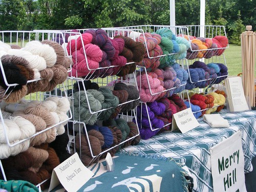
Farmer's market goods
After the downhill, roller coaster bike ride, we stopped at the local Saturday's farmer's market. Seasonal produce is just starting to come to market, so is limited. With all the rain that they've had there is a lot of concern about crops making it to market at all. We saw two vendors that remembered us from 2009. One of them had seen us with our bikes on the big hill outside of town earlier in the morning and was kind of laughing about it wondering how we had done with the ride, knowing how steep it is and how old we are. Eddie, who loves to patronize the market vendors, tries to get something from them all and ended up buying: eggs (from the cute girl with the “pet” chickens), some kind of French radishes (from the guy who looks like he could be John Stossel's brother), an almond cranberry banana bread (sold by the jolly husband who couldn't answer anything about how his wife makes it), and a free range chicken (from the farmer whose home burned down in May last year). Obviously, part of the requirement for Eddie to buy something is that the vendor has to talk to him. I enjoyed talking to the woman who has 30 alpaca to use for their wool production. I was thankful Eddie didn't have a conversation with her; I don't have time to knit sweaters or hats!
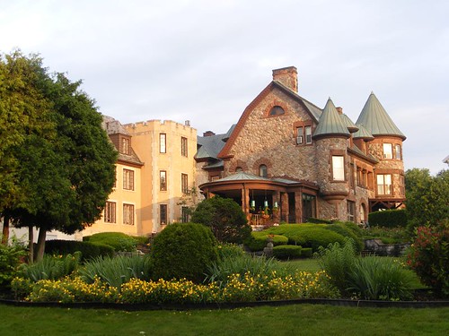
Arkell Hall
Despite the condition of the downtown, many of the1800's period homes and churches of the local community are kept in immaculate condition. Arkell Hall is a retirement home for women, donated by a descendent of the Arkell family who also founded the Beech-Nut corporation. It's park-like grounds and unique features make it a real eye catcher, and the tower peak is even visible from down on the canal.
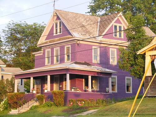
To each her own
Not everyone wants to go with the traditional look. I wasn't sure what came first: the purple color for the house or the pink flamingos!
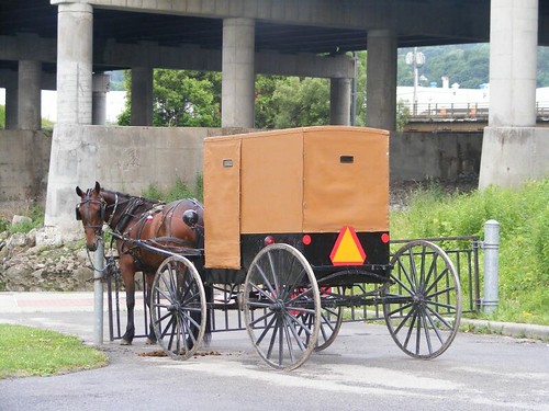
Hitched up
The Amish travel with their horse and buggy made street legal: note the head and taillights, as well as the slow moving vehicle decal. I saw these wagons go down a dirt rode next to the dock and told Eddie we should walk down there to see where they went because I thought it was a dead end. So, we did and figured out that the driver was taking people down to the canal dam (Lock 14) and dropping them off to walk across the dam as a short cut to get to their community on the opposite side of the canal.
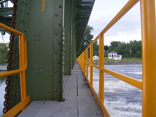
Dam walkway
When we got to the entrance to the dam walkway, there was no sign or lock on the gate, so we decided we would walk across (single file only!) just like the Amish. It was an “interesting” walk since the water was pouring over the dam with a lot of force, really vibrating the walkway. When we got to the other side we walked around the lock area grounds, which were in wonderful shape, with nice shade trees and open grounds for picnicking and lots of wall space for boats to tie up. We could see the young lockmaster out weedeating by the main road entrance, so we decided to go talk to him. Being very friendly he asked “Where did you come from?” We said “Florida”, and he looked at us and smiled and said “No, I mean, how did you get here on the lock property? I didn't see you go by me” We told him we walked across the dam. He said we weren't supposed to do that, and we told him there wasn't a sign or lock on the gate and we saw the Amish do it. He said they've been told not to do that either. Strangers on the dam are considered potential terrorist threats. So, I promised him we didn't have any terrorist intentions and even commented that only a really lame terrorist would want to take the time to blow up one of the canal dams when so many more “glamorous” targets existed.
We told him how beautiful his lock facility was and asked why it was closed to boaters and not for public use. He pointed to the railroad tracks that run adjacent to the facility and to the typical railroad crossing sign attached to the caution lights, but there are no crossing gates to block the tracks. Up until a few years ago, the lock was operated like the other ones for public use. One day a grandmother had brought her 7 yr. old grandson to the lock for fishing, and was leaving with the boy in the back of a pick up truck and stopped and froze on the tracks when the train was coming. The boy was killed, so now no one can use the facility until crossing gates are put in. That is a tragic story, but I can only think of our visit to New Bern, NC with the train tracks running right down the middle of the street, sharing the same street with cars and homes on both sides.
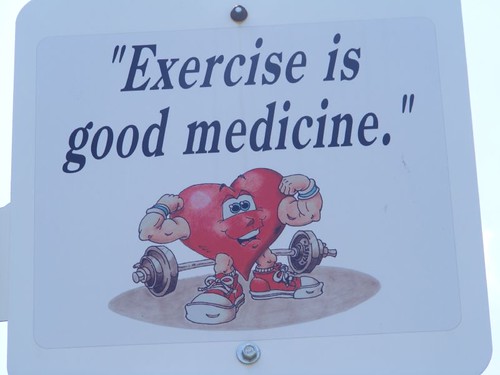
Mr. Healthy Heart
The county is trying to encourage residents to get fit and has put up educational signs and marked walking trails with mileage signs so people can know how far they walk.
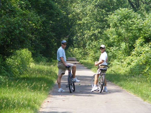
On the Canalway trail
The New York State Canal Corporation has undertaken a project to utilize the old canal corridors and tow paths as recreational pathways to encourage users (bicyclers, cross country skiers, walkers, runners, snow mobilers, and horseback riders) to get out and see their countryside and learn more about their historical heritage. When it is fully completed the Erie Canalway Trail will offer 348 miles of recreational trails. We decided we would use the trail to bike over to Fort Plain, about 5 miles from Canajoharie. This particular part of the trail is a wide, paved path, very easy to ride on.
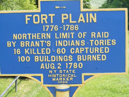
Fort Plain information
Fort Plain is the name of the town where the original Fort Plain was located. The fort was located on what appears to be one of the highest hills in the area. There are no human guides; you just walk around and read placards. When all the revolutionary fighting was going on, many small forts (some were only 12' x 12' in size) were set up at strategic locations to try to block the movements of enemy troops. Local families would move to the fort (frequently just setting up camp outside the block house) so that they could get protection too. On the hill where Fort Plain was located you get a good feel for the role these small forts played in helping the war effort. Reproductions of maps from those times showed the locations of the forts, and the important geographic features that aided in their defense, most often some river, creek, valley, or hill. There are no structures at Fort Plain because most of the fort was made of wood which deteriorated long ago. Some excavations and archeological digs have uncovered cooking areas and stone bases as well as small artifacts which can be viewed at an on site museum. We spoke to a “volunteer” mowing the field who seemed to have spent the last 60 years of his life tending to the fort area and participating in digs on the site. He lamented about the lack of funding available for gleaning more artifacts from the area and the lack of volunteers to just maintain the grounds.
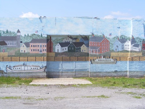
Warehouse mural
The little town of Fort Plain is very plain. There are a few well-preserved period buildings from the 1800s and a library/museum that sheds more light on the revolutionary days. Eddie asked some Amish girls who were parking one of those horse and buggy vehicles in a shopping center parking lot if he could take their picture, and they said he could take a picture of the vehicle, but not them.
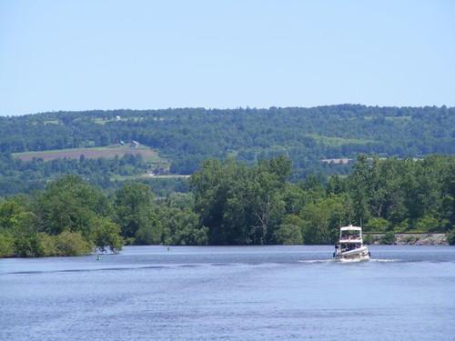
Rounding the river bend
After a nice couple of days in Canajoharie it was time to see what was around the bend and over the next hill.


'Picture perfect' - another GREAT adventure!
ReplyDeleteThanks!
Jerry