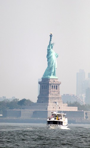
FLUKE sees the Lady
We rounded Sandy Hook in late afternoon of June 8. Since the weather forecast wasn't clear in describing what the actual wind direction was going to end up being, we decided we would spend the night in Great Kills Harbor where the wind direction wouldn't matter. There was a mooring generously made available through one of our boating organizations, and since we had never been in there, we decided to give it a try.
Favor the red markers
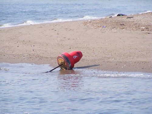
Great Kills Harbor is located on the south shore of Staten Island. That name doesn't mean that it was a site of some great historical massacre. The name comes from an old Dutch word meaning creek or channel. The channel into the harbor is well-marked. Our cruising guide said to favor the red markers. However, you can see at low tide this marker is high and dry! So, this is an example of where you have to trust your eyes and intuition to try to figure out what you should really do. Having a lot of other boats moving through the channel can also give you an idea where the deeper water is located.

Great Kills Harbor
Today, the harbor is a well-protected key hole with hundreds of mooring balls, several yacht clubs, a few marinas, a boat-launching park, and some private residential docks. I think it would be a nightmare to go in there on a summer weekend. We had heard that cruisers could anchor in there, but we sure didn't see any place that could accommodate the likes of FLUKE. Plus, shortly after we had succeeded in finding the right mooring and had gotten tied up, one of the guys that runs a launch to take people to and from their boats and shore, pulled up and drilled us on who we were and how we came to get on the mooring. It wasn't a nice “Welcome to New York” encounter. I hope he has had a change in his medication since we last saw him and has become a happier person by now.
After a peaceful, but warm, night on the mooring, we dropped the line with the intent of making our way up the Hudson River. The last time we made this trip was in 2009. I was also writing the blog at that time and provided a lot of sight-seeing information with historical documentation. So, I'm going to try not to repeat the same things from the 2009 trip. If you are thirsting for more details of how FLUKE made this journey before, access the 2009 blog.
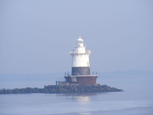
Nav marker style 1
The Lower Bay Area has several cute navigational markers of varying color and shape. They mark some of the shoals and major channels that crisscross through the area. Notice the awful haze/fog in the background. We would be stuck with that all day, making it really tough to get some nice photos.
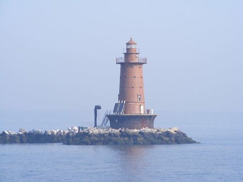
Nav marker style 2
I included this one to show the variation in style and color. Also, notice how they are sitting on the rock piles. The ones I showed you from the Chesapeake and Delaware were all in the water.
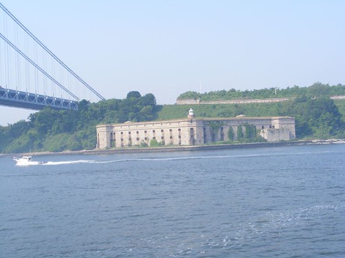
Fort Wadsworth
The Verrazano Narrows Bridge marks the division between New York Harbor's Lower and Upper Bays. Fort Wadsworth is located on the west side of the bridge, on Staten Island. Considering the poor light, I thought the fort looked pretty good, and you can see how it is tucked right in under the bridge. Of course the fort was there first, back from the 1800s. It only closed in 1994, giving it the distinction of being the oldest, continually-manned military installation in the U.S. We would be traveling on the west side of the Upper Bay, fighting a current all the way which makes for a slow passage, but gives us more time to look around.
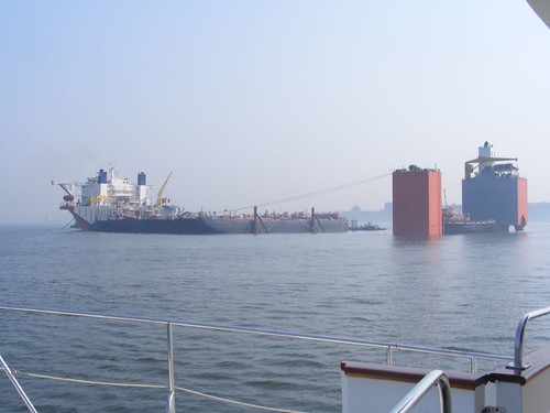
BLUE MARLIN
Our best surprise of the whole day was seeing the BLUE MARLIN (part of the Dockwise fleet) anchored right in the middle of the Bay, either loading or off loading a whole fleet of tugs and barges (we couldn't tell which way the cargo was going). We first learned about Dockwise because one of the boats we looked at when we were searching for a trawler came with a “pass” on Dockwise for passage to the Mediterranean. The ships are designed for transporting other ships. Even if you aren't into boats, you can't help but be amazed by the technological marvel of the Dockwise ships. In this photo, the left hand side shows the front of the ship (the bow isn't visible from this angle); the right hand side shows the aft end of the ship which looks like those two big boxes sticking out of the water. In between, is where the cargo is loaded by partially submerging the ship (up to 50' deep!). What you can see here, are a lot of black barges packed in side to side. In front of the barges, not visible in this photo, were several tugs, packed in right up to the white part of the ship. When all the cargo is loaded, the water is pumped out and the cargo is transported “dry”, anchored to the deck of the ship. There were many other tugs and barges of the same company anchored in the harbor, either waiting to get loaded or unloaded.
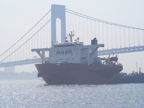
THE SHIP and THE BRIDGE
Here you can see the bow of the BLUE MARLIN with the majestic Verrazano Narrows Bridge in the background. Right away you should notice that the bridge of the ship is so far forward compared to other freighters or tankers. That's because of the nature of the cargo that the BLUE MARLIN carries, which would block visibility if the pilothouse was aft. If you Google BLUE MARLIN you will see some amazing photos. It carried the U.S.S. COLE after it was bombed, and you will see the photo of the COLE on the BLUE MARLIN deck. You can also see that the BLUE MARLIN carries those gigantic deep sea oil rigs.
Ferries, ferries, everywhere
We have to be on the lookout for the people ferries, not just the Staten Island ferry, but the water taxis, the ferries from the Atlantic Highlands, and tour boats. They are going in all directions, and some of them really move fast.

EXPLORER OF THE SEAS
This cruise ship was at her berth; we had never seen one berthed there before. So, if someone says “I'll be at the cruise ship dock in NY” you'd better ask which one, since this is the third one we've seen. Another cruise ship was at the Marine terminal north of lower Manhattan when we went by later on.
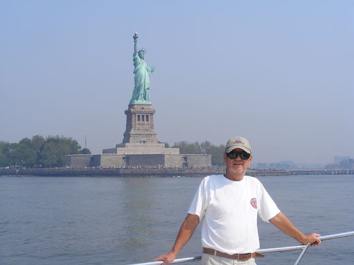
Eddie and the Maiden of the Harbor
I'm not sure you can have too many pictures of the Statue of Liberty; time of day, amount of light, the haze, and the angle all give her a different look. Look at all the people walking around the base of the statue. One thing is for sure, she is amazing to see from your own boat. You probably wonder how we got the opening photo. It is not photoshopped. 5 days after we passed Lady Liberty, we ran into a cruising couple who happened to be in the harbor behind us, and they took the photo thinking they might see us again along the way. Wasn't that nice?!
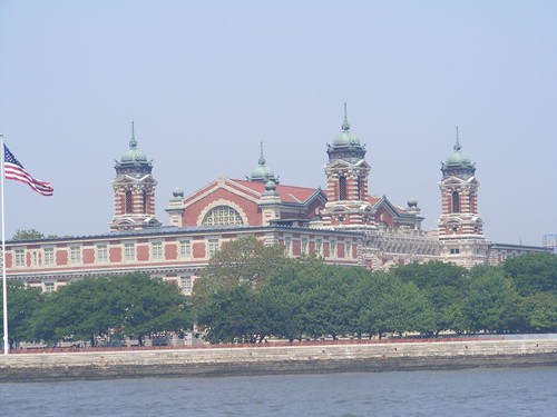
Her neighbor
Right next door to the Statue of Liberty lies Ellis Island. The building has a beauty all its own and distinctive to the whole area of Lower Manhattan across the Bay. It was at this point we crossed over the Hudson to the Battery and began our slow trip up the Hudson.
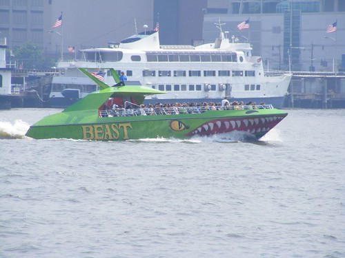
For taking a quick tour
If you want to tell people you took a tour of New York Harbor by boat but don't really want to spend the time for a leisurely cruise, you take this thing. Hold on to your hat, and bring your ear plugs; THE BEAST is fast and really loud. Yuck.
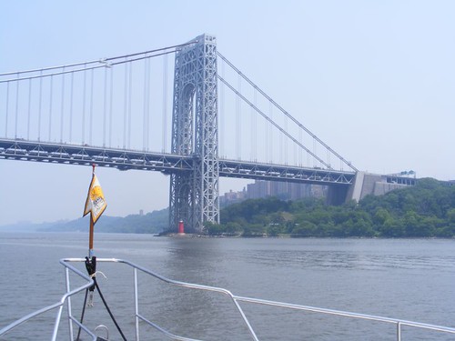
George Washington Bridge
I think the GWB marks the transition from what I think of as New York City to the beautiful Palisades and points northward. The waterway narrows, water traffic decreases, and the buildings along the shoreline take on a different look with less high rises and not the famous skyline of all the movies and news stations that you are used to seeing.
We can relax a bit as we settle into the groove of moving north up the Hudson to our next destination. I've decided it's a good point to conclude another blog segment of our adventure.


Loving it - thanks for letting me join in on your adventure!
ReplyDeleteJerry
What an incredible travelogue you have compiled! You should have enough material for several coffee table books. How about, "Lights and Markers of the Eastern Seaboard", for one. I want to be at the book signing.
ReplyDeletehandymanalex
Great pictures! Looks like things are going smooth. I just got back from Vero:) No rain down there, or up here in NC.
ReplyDeleteAl