When you get up to the far end of Chesapeake Bay it becomes very narrow and the landscape changes dramatically. Whereas the lower parts of the Bay and its associated islands are lined with marsh lands, the upper part of the Bay where it enters into the C&D Canal is marked by high, tree-covered bluffs.
The C&D Canal construction took advantage of how the natural, deeper waterways began at this end of the Bay and were in closest proximity to the lower marsh lands of Delaware Bay to the East to try to link the two bodies of water with the least amount of digging. The government-owned canal is officially 13 miles long and maintained to 35 feet deep.
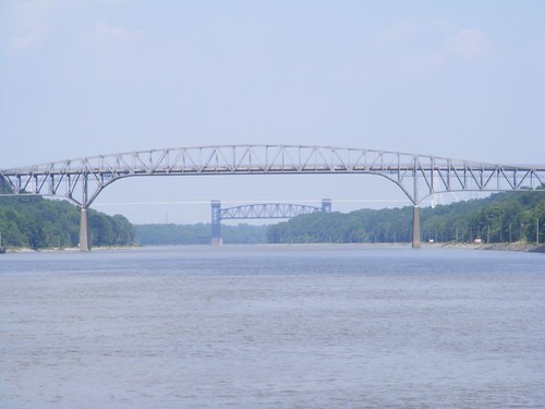
Bridges over calm waters
There are four fixed bridges and one vertically ”movable” railroad bridge that cross over the Canal. They have to provide a minimum of 135 feet of clearance underneath so that the ocean-going freighters and tankers can pass safely. This photo shows one of the fixed bridges and the dark railroad bridge beyond that. If you look closely you can see a thin, white pipe between the two bridges; it is a natural gas line that crosses overhead. The structures on shore that support the pipe are enormous.
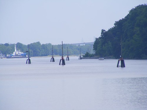
Follow the lighted waterway
The Canal is fully lighted like an airport runway to be made safer for nighttime transits by the commercial vessels. This photo shows how the lights have to be put out in the water where there are bends and shoaled areas in the canal. If you look closely in the previous photo you can see how the lights line the shore on either side of the canal; they look like telephone poles.
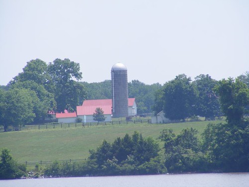
Farming along the C&D
While there are sections with residential homes overlooking the Canal, there are also lots of big tracks of farm land. I always enjoy looking over these lands to see what crops are being grown. Several of the big farms have grazing land for horses. I was looking through the binoculars at a farm that had several pretty horses in a paddock area. There was also another barn and paddock on the same property and when I looked over to the other area, I was completely surprised to see two zebras! Eddie will be “on alert” when we go by there on the return trip because he was too slow to get up to see them this time.
This is the first time we have gone through the canal without passing any commercial vessels. Remember what I said earlier about the signs of a sluggish economy.
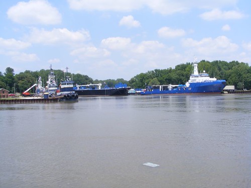
The Ever Ready fleet
About midday through the Canal is a facility where a whole fleet of emergency response vessels are docked. There are several tugs capable of pushing or pulling commercial vessels, a tanker ship that could render assistance for liquid cargo, and a ship equipped with a large crane and capable of holding a lot of shipping containers. The facility is strategically positioned to aid vessels in peril in the reaches of upper Chesapeake Bay, the Canal, and on Delaware Bay. Every time we pass here I always marvel at what great shape all the ships are in. Their matching blue, white, and yellow paint jobs are striking.
The C&D's east end is as nondescript as the west end is breath-taking. You simply pass through a breakwater rock dike and spill into Delaware Bay. Then you have two choices: go north all the way up to Philadelphia or south towards Cape May, NJ or the Atlantic Ocean. Most every time we have passed through Delaware Bay, the weather has been some sort of state of lousy: either rain, wind, cold, fog, or all combinations. We sure were surprised to have glassy waters as we headed south to Reedy Island where we anchored for the night. That's where I was writing Part 1 of this segment of the blog. I'm writing this section as we ride in the Atlantic.
The Reedy Island anchorage is kind of strange. It is “protected” from the main waters of Delaware Bay by a rock dike that extends 3 miles in length. We have wondered what the dike was ever made for in the first place, but I have yet to find that out. The entrance through the dike is marked with green and red nav signs and it is easy to get in and out, and there is plenty of room to drop the hook. Reedy Island is small, but would give a little protection from east winds and the nearby shore land gives some protection from the west. However, you are really open to winds from the north and south, and the current is ripping by at 2 or 3 knots, so you need to make sure you have your anchor set well and have confidence in it to hold when the current switches in the middle of the night while you are asleep. We have always found the holding here to be very good, and it is so convenient to stop here to be able to make the run all the way to Atlantic City the next day, albeit a long one.
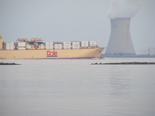
There is nothing wrong with irradiated fruit
This photo was taken while we were at the Reedy Island anchorage. You can see a portion of the rock dike at this tide level. When it is fully high tide, most of the dike is submerged, so it is very important to know where to get in. You can watch the sights go by as you calmly sip your wine from Vineyards on the Scuppernong if you're not creeped out by being right across from the nuke plant. It is kind of eerie at night because the whole facility is lit up like Christmas and lights flash on top of the cooling tower that reflect off the ever-present steam leaving the tower, lending a strange sight in the night sky.
None of us were bothered by any of that, and we slept soundly until our 5:00 a.m. wake-up alarm. We were underway within half an hour. As the sun peeked over the horizon a blanket of dense fog settled over Delaware Bay. Fortunately, the big ship lanes are clearly marked on the charts and we always travel outside those lanes. However, visibility was less than 100 yards. We could hear commercial captains transiting the C&D saying that they had zero visibility and were posting warnings to any vessels traveling their area. The C&D will actually close during foggy conditions to traffic like us, but if you are already in there when the fog sets in, you have to either anchor or proceed with extreme caution. We still had to worry about running into other small boats, nav markers, or floating debris, so all 3 of us kept a vigilant watch. We were using our radar and had our hailer on, which emits a long horn sound every 2 minutes. Moving under those conditions is very stressful and we were relieved as the fog began to lift.

Miah Maull light
This particular light is towards the southern end of Delaware Bay and is used to mark a shoal that is adjacent to the shipping channel and is equipped with a light and a horn. This was the only time we've passed it when I could finally manage to get a decent photo, thanks to the fog lifting. It is in pretty decent shape, but is loaded with bunches of gulls at every level. I have no idea how it was named.
Crossing the Bay would get us into New Jersey territory, where Part 3 will unfold.


Your recent posts have been very informative, both from the details about traversing the traffic and from the photos of the lights that are more industrial looking than us Carolinians are used to seeing.
ReplyDeleteFrom the Wikipedia:
ReplyDeleteThe name of the shoal commemorates Nehemiah Maull, a river pilot who was drowned in 1780 when the ship in which he intended to sail to England was wrecked on the then-unnamed shoal.
We have been enjoying your blog, thanks!
Kristina & Atle
Great pictures and narrative...as always...thanks!
ReplyDeleteBob and Dorinda
Prediksi Togel Wla | Code Syair SGP | Code Syair HK | Code Syair Sydney Forum Syair Sgp,Forum Syair Hk,Forum Syair Sydney,Gambar Syair Togel Hari Ini,Prediksi Syair Togel Hari Ini,Bocoran Syair Togel,Bocoran Syair Hk,Prediksi Sgp, Syair Togel Jitu,Prediksi Hongkong,Syair Hk, Prediksi Singapura, Prediksi Hk, Syair Sgp,Syair Sydney,Prediksi Sidney,Syair Singapura,Bocoran Sgp,Bocoran Singapore,Syair Sidney,Syair Singapore,Prediksi Singapore,Syair Hongkong,Data Hk,Data Sgp,Live Draw Hk,Live Draw Hongkong,Live Draw Sydney,Prediksi Togel,Nomor Hongkong, Keluaran Hk,Keluaran Sgp Terlengkap,Prediksi Togel Hari Ini,Prediksi Angka Jitu,Prediksi Togel Sgp, Bocoran Togel Hk,Syair Togel Sgp,Prediksi Jitu Hk, Angka Jitu Sgp,Agen Togel Terpercaya,http://162.0.225.215 salah satu situs prediksi togel,bocoran nomor sgp,syair togel terlengkap, syair hongkong,nomor jitu hk,bocoran hk,bocoran togel,prediksi togel sgp,syair sydney,bocoran singapore, bocoran singapura,bocoran hongkong, prediksi togel hk,prediksi togel sidney, prediksi hongkong,syair sgp, syair singapore,syair togel hari ini dan keluaran nomor sgp,data hk,data hongkong,data sgp tercepat,keluaran sgp,keluaran hongkong,live draw togel,live draw hk,live draw sgp,live draw hongkong,live draw sydney,live draw singapura,live draw sidney,live draw singapore, live sgp paling cepat dan akurat,TAFSIR MIMPI,BOCORAN SYAIRTOGEL,BOCORAN SYAIR SGP,BOCORAN HK,BOCORAN SYAIR SIDNEY,PREDIKSI TOGEL WLA,CODE SYAIR SGP,CODE SYAIR HK,CODE SYAIR SYDNEY : Syair Prediksi Jitu WEB Atau Blog Di Buat Untuk Mempermudah Para Prediktor Syair Untuk Melihat Lebih Detail Dan Terperinci Akan Syair Prediksi Yang Kami Hadirkan Setiap Hari Nya.Jika Anda Menyukai Prediksi Angka Jadi WlA Tentunya Anda Bisa Juga Mengunjugi Blog Kami Lain Nya : Prediksi Togel Wla | Code Syair SGP | Code Syair HK | Code Syair Sydney
ReplyDeletePara Prediktor Syair Togel Juga Bisa Mengunjugi Site Blog Kami Yang Lain nya Disini: ASAL NGEBLOG – TAFSIR MIMPI