Part 1: Kingston Mills Lock
I'm writing this on August 11 and have no idea when I will finally catch up. The reasons I am behind are: not having time to write out the blog (we are on the go, land or water, all the time), trying to think of a good way to organize the Rideau Canal trip, very limited internet access, and delay in getting my journal and travel research documents in order. Sorry about the back log, but I am now ready to share the journey and hope you will enjoy hearing about it as much as we have delighted in experiencing the wonders of this historic part of Canada and all the people that we have crossed paths with.
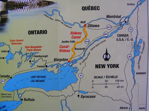
Rideau Canal overview
This photo was taken from a Parks Canada brochure and shows the basic route of the Rideau Canal as well as the other waterways we have already traveled and those that still lie ahead of us. Although, if we don't get moving those waterways may be iced over and we will have to rent a car to get back to Florida!
The construction of the Rideau Canal may have been the greatest engineering feat of the 19th century. In 1826 England sent Lieutenant Colonel John By of the Royal Engineers to supervise the construction of a canal that would link Kingston and Ottawa so that a secure supply route could be maintained. Then goods and troops could safely move from Montreal and other settlements of Upper Canada all the way down to the naval shipyard and port at Kingston. That travel used to be done by way of the St. Lawrence, but since the War of 1812 was recently fought and there was still politically wariness and distrust toward the Americans who controlled the St. Lawrence, the British felt having their own secure waterway was the way to go in case war broke out again.
The Rideau Canal utilized existing rivers and lakes and required back-breaking canal cuts to connect them all together to form the 120 mile long canal, which was completed in 1832, a miraculous 6 years after it was started. Of the 2000 men that worked on the canal, it is estimated that 500 died from malaria since so much work had to be done through swamps and marshland which supplied limitless breeding grounds for mosquitoes that transmitted the disease. Many more men died from accidents associated with blowing up the rock used for the canal, felling timber, overexposure, and malnutrition. Yet, the canal and associated structures are masonry and engineering works of art, a real tribute to all those that persevered to bring the waterway to fruition. It is a joy to experience it today much like it was almost 200 years ago. Minus the mosquitoes, of course!
FLUKE at our first lock dock
After cleaning all the Cataraqui River goo off the anchor, we headed 5 miles north to Kingston Mills lock. It would be our first opportunity to learn about the Rideau locks and how the system worked. We will be traveling upriver for the first 14 locks, meaning the locks will be lifting us up to the next level each time. Then the next 31 locks will lower us down.
When we pulled near the first lock a canal employee came down to the lower dock and told us to move into the open lock. I yelled over that we wanted to tie up at the dock rather than go through at that time. The system requires that if you want to go into the lock, you tie your boat up to what is called the blue line. It is a blue line painted on the dock side or top. If you don't want to go through, you tie up at the “gray”, or unpainted area, if such an area even exists. All the locks do not permit overnight tie ups. Kingston Mill lock has space for overnight stays at both the lower and upper lock areas. We needed to be able to look at the lock-through procedure and understand how we could safely move FLUKE through the locks since they are not the same as those of the Erie and Oswego Canals.
FLUKE is not your typical cruising boat for the Rideau system, and I will say we saw only one other southbound boat that matched us in size and weight. So, it is a big deal when a boat our size shows up. The canal employee appeared to be a bundle of nerves, and I knew he was inexperienced in dealing with large vessels. Most of the boats are lightweight, go-fast vessels that you can push along the docks or locks by hand. FLUKE can't be moved like that, and it can be dangerous to think you can just push or pull her away from or towards the dock or lock wall. The canal employees assist in tying up vessels, so I handed him one of our dock lines, and he fell into the water! I was so afraid he was going to get between the boat and the dock, but he had sense enough to try to pull himself close to the dock and keep away from the boat since we were moving forward. I jumped off the boat to secure the stern while another boater was helping the canal worker get out of the water. So much for our first landing!
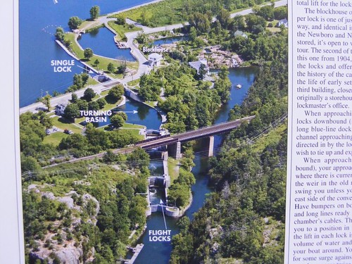
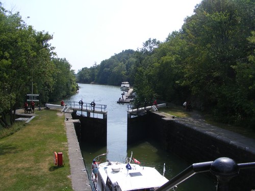
Kingston Mills Lock overview
I'm going to use a few of these aerial shots of some of the locks to give you a feel for the areas and some of the lock set-ups. They are all taken from the PORTS cruising guide, a valuable publication to have on board, if for nothing else but the photos.
The name of the lock comes from the fact that it was the site of an original, very successful mill operation. Colonel By had to purchase, or use the equivalent of eminent domain, land for the canal. Sometimes that was complicated by the existence of such mills, and the property owners held out for as long as they could until they felt they received fair compensation.
Most all of the locks were constructed where there were natural cataracts, rocky changes in water elevations, like rapids. If you look in the photo where it is labeled blockhouse you can see a rocky area directly to its right. That is where the original river flowed downhill, creating the energy to power the original grist mill. Today, those areas are still utilized for hydro power stations, also visible in the photo. To the left of the blockhouse you can see a “pool”, which is part of the dam system that helps regulate water flow into the power station and through the lock system.
In the bottom part of the photo you can see the dock that we tied up to. This lock has what is called combined and detached locks. The combined locks are labeled flight locks. When you enter them, you move from one lock to the next as the water level fills to move you up to the next level, in this case 3 locks. Then you enter the turning basin. It was designed to let the original steam powered vessels load or unload supplies or sit for maintenance purposes. Now, vessels are not permitted to stop, and so must proceed upward into the single lock after passing under the swing bridge, or waiting for it to open if you are too tall like we are. All four of these locks have a combined lift of 45'.
Notice the blockhouse. A total of 4 of them were built on the waterway. They were designed to hold small number of soldiers to defend the lock in the event of enemy attack. Colonel By wanted one at each lock, but he was forced to make budget cuts and had to stop at just 4. Back in those days, there was a principal in play that said governments weren't permitted to spend money they didn't have. It was already apparent that taxing the masses, rich OR poor, only resulted in revolution, so the government wised up and actually tried to show fiduciary responsibility. Gee, what a great idea, maybe my blog should go to Washington! You can do your part by remembering that important concept when you vote in 2012.
To the left of the text “turning basin” you can see a house set amongst the trees. This was the lockmaster's house. Several of the locks have those houses restored on site, and they are open as small canal museums. They are a wonderful way to learn about the history of the specific lock or about some interesting aspects of the canal project.
Going right over the flight locks, is a railroad track still currently in use. This lock is the only one that has the track going over it. Freight and passenger trains pass quickly over several times per day.
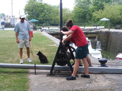
The chain gang
All but four of the locks on the whole system are operated in the original fashion, by hand-cranked chains cranked by “crabs” as seen in this photo. It takes about 20-30 minutes to go through one lock, so in the case of the Kingston Mills locks, it takes almost 2 hours to go from the bottom to the top. There is a Parks Canada lockmaster on site during all operating hours, and during the summer season, college students (as seen in this photo) are hired as employees. The canal operates from May – October.
There was a move to convert all the locks to be hydraulically operated like those on the American canals, but after 4 of them were completed, an outrage erupted, declaring that the system was losing its historical flavor and the conversions were stopped. Having them operate hydraulically wouldn't really save any locking time.
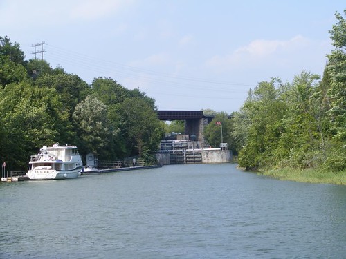
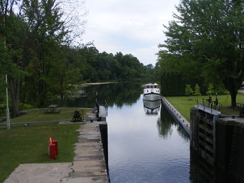
Locking down
In this photo you can see FLUKE downstream at the dock, and the boat coming out of the lock is locking down, as evidenced by its bow pointed toward FLUKE. You can also have a feel for the beautiful, winding, narrow waterway that had to be cut through this area.
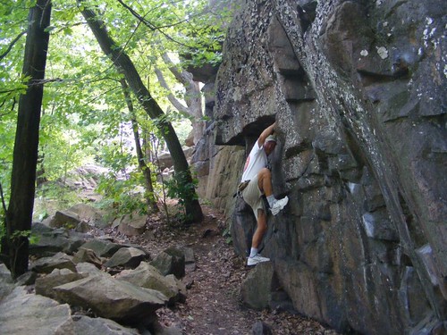
Rock solid, the boulder, not Eddie
Both sides of the waterway next to the dock looked like this. There was a great path that ran along the water and up onto the ridge. We got to see a muskrat digging in the mud bank, and when he saw us he jumped into the water and swam to the other side.
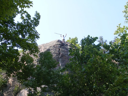
Top climber
We had a difficult time trying to find the path through the boulders to get to the summit. I had to go back to FLUKE to cook dinner, where I assumed my role as the galley slave. I heard Eddie yell out and looked up to see that he had found the trail to the top. I was annoyed that I didn't get to go up.
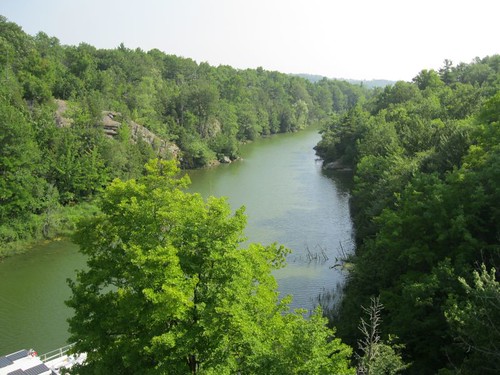
A view from the top
Eddie took this shot of the pretty view of the waterway to the south.
The most important order of business was to talk to the lockmaster about the real odds of us being able to successfully transit the entire Rideau Canal. While a sistership had done the trip last year, water levels can vary and there may not be enough for us this year. We were particularly discouraged when we looked at the distance from the empty lower lock sill up to the water level on the gate, and it sure didn't look like it was barely 5' in height. We always have wanted at least 5.5' of water for FLUKE in salt water, and in fresh water, fully loaded she would not float as high. Plus, we would really have to be on our own as there are no aid vessels that are large enough to help boats as big as FLUKE if we needed to get pulled off a ledge or through a mud flat.
Locks can accommodate vessels up to 90' in length and 26' in width, which is fine for us. However, they will only “guarantee” water level depths maintained to 5', so that was marginal at best for us.
The lock staff is a great group of people. Many of the lockmasters have been with Canada Parks and the locks for a long time and know the canal well. After our conversation with him, and the fact that as we were entering the system with water levels that were still on the higher side due to flooding in the spring, we decided to go ahead. We had to sign a waiver saying that we would not hold Parks Canada liable for damages to our vessel. Our lock-through fee was $422.40. The mooring pass we had bought in the Thousand Islands would also enable us to have unlimited tie-ups to any of the gray lines in the Rideau system.
As I was falling asleep that night I mumbled to Wayne “I hope we are doing the right thing”.
July 22, 2011
Part 2: Upper Brewers
The locking hours on the Rideau Canal run from 8:30 a.m. - 7:30 p.m. during the season. Some of the locks, like Kingston Mills require you to get there 1.5 hrs before closing to make sure you can lock through before closing time.
Since we spent the night there, we were right on the blue line for the 8:30 a.m. opening along with several other boats. Having never gone through before, we decided to wait until the next opening in hopes of getting to go in by ourselves since the wind had picked up quite a bit and we wondered how much we would move around in the lock chambers. That turned out to be some kind of canal fantasy since the locks were always busy. Because we did wait, we didn't enter the first lock chamber until about 10:00 a.m.
It turned out that the lockmasters always put the big boats in first since they have the least maneuverability and if a little boat gets out of position it is less likely to do much damage if it strays into another boat. All the boats have lots of fenders on both sides to protect from the lock walls and other boats.
When we finally entered our first chamber we moved in over the sill slowly, holding our breaths, hoping that we wouldn't feel and hear any scraping of the bottom. Then we just took our time and eased into the wall so that we could put our lines, fore and aft, through the cables that would hold us in place as the lock was filled with water and we were slowly raised up to the next level. The lockmaster always filled the chambers with the most water he could to give us the best chance of not bottoming out in the lock. Then we held our breaths again as we eased over the exit sill and into the next chamber.
The process repeated itself through the 3 combined chambers of the lower lock area and then through the upper detached chamber of the Kingston Mills locks. It took us about 2 hours to go through those locks and the swing bridge. It was a confidence booster to get through that set without hitting the bottom.
We exited into Colonel By Lake, a wide, mostly deep lake created by flooding the Cataraqui River when the locks and dam were built at Kingston Mills. You can still see a lot of dead heads, old tree stumps that were present before the flooding. So, it's important to stay in the deep water.
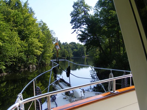
Colonel By Lake emptied into the River Styx, a very narrow channel (only 100' wide). At least it has a lot of buoys marking the channel because we barely had a foot of water under us in most places so we had to be very careful to stay within the boundary of the buoys; we were only traveling at 5 KTS or less. Obviously, our shallow water problems weren't just going to be within the locks.
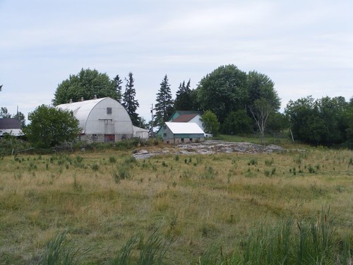
Riverside dairy farm
The land areas through this section had a lot of farm land, crops of some sort and dairy farms.
We also passed by a prison that was surrounded by farm land. Maybe they have the inmates grow some of their own food; not a bad idea.
We had gathered some important cruising information from other cruisers and lock workers that we had spoken to at Kingston Mills. The last week of July and the first week of August are considered the Construction Holiday in Montreal. Construction projects shut down, so allied trades that are associated with that business also shut down. Many French workers go boating during that period and flock to the Thousand Islands via the Ottowa River or the Rideau Canal. Many of them do a loop like we are doing. So, that means we are competing with dock and lock space with many boats during that period. Just another thing to have to deal with.
We caught onto how the other boaters move very quickly and figured out that we needed to get to a dock space at the lock very early in the day and plan on being ready to lock through at each first lock time when possible. The one thing we had in our favor was not needing “hydro” at the dock. Remember, I told you that the go-fast boaters are addicted to hydro, so they try to stay at the docks that supply hydro.
FLUKE at the lower dock of Upper Brewers
For our second night, we ended up at Upper Brewers lock by 3:30 p.m., only 11 miles from where we started the day at Kingston Mills. It is really in a rural setting, and doesn't have any hydro at the dock; that's why we are the only boat at the dock.
There is also a Lower Brewers, but it supplies hydro. When we passed through there, 2 miles previous, all the dock space was already filled up. Everyone was sitting in the shade under the trees sipping their wine and watching us go by, probably wondering if we were sane thinking FLUKE was going to make it through the canal.
The Brewers Locks were named for John Brewer who had successful mill operations (saw and grist) in the area. Coincidentally, he also started one of the first breweries in the colonies. He sold out everything to Colonel By when the lock construction began.
We had a wonderful, quiet night at the dock, all by ourselves, except for all the fireflies that lit up the shore. I didn't know how so many could be in one place at the same time.
Only wide enough for FLUKE
We locked through the double lock chamber (16.5') without incident at the first lock opening. We had a mile of a very narrow, tree-lined channel. We would have been challenged to have enough room for another boat to pass by us and be able to move to one side and still have enough water under us.
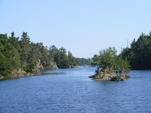
You must follow the channel markers
The channel opens up to some picturesque scenery. It is beautiful to see the sun reflecting off the big rocks on shore with the weathered trees growing out of the cracks on what little soil has accumulated. Channel markers give critical information as to what side of the rocks to pass on.
There are cute names for the land and water masses. We traveled through Cranberry Lake until we reached the Brass Point swing bridge.
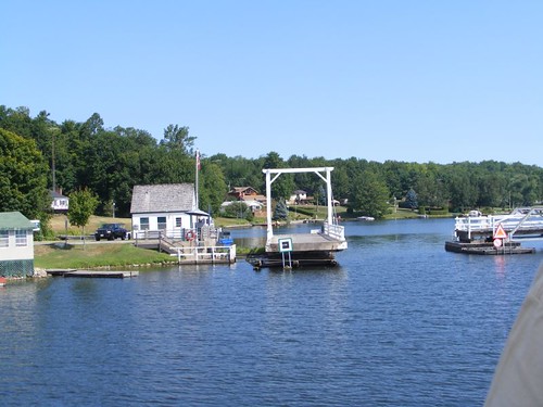
Brass Point swing bridge
This bridge has just 4' of clearance above the water, so it has to open for almost every boat that passes through this area. Fortunately the area is very rural, so there isn't a lot of automobile traffic. That means boats don't have to wait long for it to open.
Notice in the photo that the opening is very narrow; we could only pass through by ourselves, aligned straight in the opening. On the left hand side of the bridge you can see an umbrella. That is where the Parks Canada bridge tender keeps out of the sun while he operates the hydraulic controls that move this bridge. What is unusual to us is that the bridge tender, or any of the lock operators, do not communicate with boaters on the VHF radio. You have to ease up to the bridge area and yell or wave for an opening.
Even though we had only traveled another 10 miles, we decided we wanted to get away from the hubbub of civilization and the dock life for a couple of days and explore a more remote area that appealed to our sense of adventure. So, we turned off the main canal waterway and headed into Morton Bay to anchor out and commune with nature.


Please post the picture of the fireflies. Thanks! ;)
ReplyDeletehandymanalex