June 2 – 5, 2012
Clarence Town, Long Island
It took 11 hours and 20 minutes to go the 74 miles from our anchorage at Cat Island to reach our destination of Clarence Town on Long Island. Long Island is situated the same as I described for Eleuthera and Cat Islands: north to south, open to the deep Atlantic on the east. Clarence Town has the first eastern side harbor you come to from the north, about 50 miles from the northern tip, so much of our time was spent along the eastern coast of Long Island. We also passed south of the Tropic of Cancer, 23.5 degrees north latitude. The star patterns in the sky really do look different this far south.
The long day was made more enjoyable because the seas had settled down quite a bit, giving us a more comfortable ride for a change. It was only cloudy until noon, with no rain showers, and then the sun finally came out. Hooray for sunshine!!
Everyone was calm
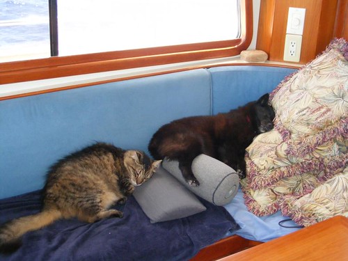
We had some real fishing excitement: 1 Spanish mackerel, 1/2 tuna (didn't see what bit the other half), 1 barracuda, and 2 dolphins on at the same time. We managed to get the smaller of the two in the boat, dinner for later that night and some for the freezer.

This one didn't get away
Right when we were trying to get the dolphin back to the boat, the mailboat, SEA SPIRIT II was on its biweekly run from the south and called us to request a port to port pass. It wasn't apparent to the captain what we were going to do since we had stopped to try to bring in the fish and were just bouncing all around.

Hi on the high seas
Poor baker Wayne had tried to make a loaf of bread underway, but with all the heat and humidity it rose too quickly and got stuck to his cover cloth. Then it kind of collapsed in the oven, not rising to its full potential. We never throw out bread like that, but it doesn't work well for sandwiches, so we use it for eating chunks with meals.
Clarence Town is easily spotted from the sea because of the two starkly white churches that sit high above the harbor. Father Jerome built both of them in the style of Moorish architecture (before he was a priest, he was an architect). They are not rough-stone, primitive structures like the quaint Hermitage on Cat Island.

St. Paul's Anglican church
St. Paul's was built first. Then Father Jerome switched to the Catholic religion, maybe for better money. So then, he had to build a more elaborate church to outdo the Anglican church and built St. Peter's Catholic church, easily visible from St. Paul's. I find it hard to believe that both these churches could be supported by the small community.

St. Peter's Catholic church
Our main goal was to be able to find a comfortable spot to drop the anchor. While the harbor has several areas where the holding is good in a sandy bottom, it is open to the north, so ocean swells do come in, making for a bit of roll throughout the whole harbor. Shallower draft boats can move up much farther in the harbor and maybe get a bit more protection. We needed to find a spot to accommodate our 5 1/2' draft and have a little extra room in case conditions got bumpy.
Our northern view
The surrounding cays have pretty sand beaches with tropical vegetation. The land side of the harbor has several hilly areas with a variety of vacation homes, some of which are large and modern.

Our eastern view
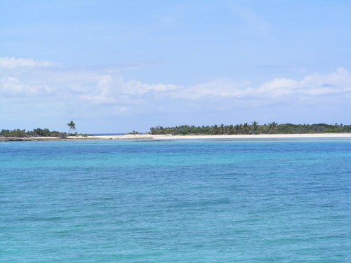
The rock barrier reef on the east side helps keep the waves from rolling in at full force, yet you can still get a bit of ocean breeze. All night long you can hear the waves breaking on the rocks. The views from our anchorage were nice; all the colors you hope to see in the out islands. The photos just can't capture the truly magnificent colors.
The following day after our arrival we stayed close to the boat because of scattered rain showers in the area; we wanted to make sure that we were going to hold tight when the wind shifted directions or increased in intensity. In the late afternoon we launched the dinghy and took Ursa for a beach walk on one of the nearby cays. Eddie and I did some beach scavenging and picked up a few “treasures”.
On the third day, we went into the settlement for a land tour on foot, try to find a phone, look for the grocery store, and check out Flying Fish Marina. Since Clarence Town is the capital of Long Island, silly us had high expectations.
The first stop off the Government dock is the agricultural packing house. It is said that you can buy whatever they may be packing if they are open and have produce available. There were several women sitting inside, and I walked over to the loading ramp and asked what they were packing. She said papaya, plantains, and bananas, but I only saw a couple of papayas on the rolling conveyor belt, and they weren't on my list.
BATELCO is the phone company here, and since we could see their tower from the harbor, we figured we would just go to their office to make a phone call. When we were in New Bight on Cat Island, I had noticed an abandoned phone booth, and when we left the government dock here at Clarence Town I saw another abandoned phone booth. I was beginning to get a bad feeling about the phone situation.
When we reached the top of the hill where the Government Administrative Office shared the same building with the BATELCO office, I was puzzled why it looked like there was a lock on the BATELCO part of the building. I decided to inquire in the GAO and walked in the door.
The air conditioned small single room looked like it was used for a multi-purpose meeting room, including having an elevated area with a railing and dias that looked like it could be used for court proceedings. There was a recorder playing a young girl's poetry recital, but no one was in sight. A bulletin board had governmental public service announcements posted on it. One of them caught my attention: about keeping mosquitoes out of your house by putting up screens and spraying pesticide thoroughly inside, and waiting a few minutes for it all to settle before reentering. I saw an alcove over to one side and could hear voices, so I peeked around the corner.
A woman saw me, and I asked her about the phone company. She said that the office is no longer maintained in Clarence Town. She also said that no one uses the phone booths anymore, they all use cell phones, and they buy the minutes from the company. In times past, you could buy a card with minutes on it to use in the phones, but I guess it isn't worth maintaining the phone booths any more. When she asked me if I had a cell phone, and I said no, she looked at me like I had two heads and must have come from another planet. The closest phone office was 6 miles away, so I gave up the idea of making a phone call until I could get a strong WiFi connection and use Skype. That wouldn't be happening here in the capital city, though.
Further up the hill, we came to St. Paul's church. The view of the ocean to the east and countryside to the west was breathtaking. As we got closer to the church it looked like it was undergoing some sort of renovation. All the glass windows and doors looked new, and there was a pile of lumber outside, but it was still trussed up covered with a rotting tarp.
I was surprised when I looked through the door and saw that the whole roof was missing in the middle portion of the church. Benches were pushed to one covered side, and the altar area had a roof over it. There were even several floor fans, as though they still hold service in the church, probably if it isn't raining. That's what I call a direct connection to the heavens!
Those souls don't need a roof any more
Grave stones surround 3 sides of the church. When I went around to the side opposite the road, I saw where the roof of the church was – laying on top of the headstones. Judging by the weeds growing up through the debris, the roof had been there a while. Look in the distance of the photo, and you can see St. Peter's church. We planned to walk over to that hill after we tried to find the grocery store.
In days past, several of the Long Island communities had salt mining operations. The basis of the operation was the utilization of the many naturally shallow ponds that could be flooded on high tides, and then barricaded off to allow the salt water to evaporate, leaving the salt behind to be scraped up. That's real sea salt. The area around Clarence Town still has some of the old filling canals and ponds visible.
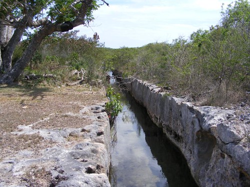
Salt canal
Notice the thick rock that had to be dug through to construct this canal. The chunks of rock were put to use for the construction of field walls and property line fences. With the salt mining operations no longer in production, the water flows in both directions according to the tides. We were going by on a falling tide and could see the surprisingly swift current running toward the sea in the canals we passed.
As we got nearer the area where we thought the grocery store should be, I told Wayne I thought I could smell goats, but we didn't see any. When we were right outside the grocery store I looked down on the ground and saw piles of goat turds. The tiny grocery store only had a few shelves of food products and no fresh produce of any kind. It had open air windows and I told Wayne I could still smell goats and happened to look out a window and saw a half dozen sheep huddled in the shade of a tree behind the building next door. This island is known for the availability of mutton, so I guess you could get it really fresh if you wanted! No mutton chops for the FLUKESTERS, though. Baa!
We had to walk by the police station to get to St. Peter's church, and were surprised to see two police cars in the little lot. That has to be a high rate of coverage for the population, unless only one of the cars is operational at any given time.
It is worth the walk up the hill to visit St. Peter's and view the rest of the community from above.
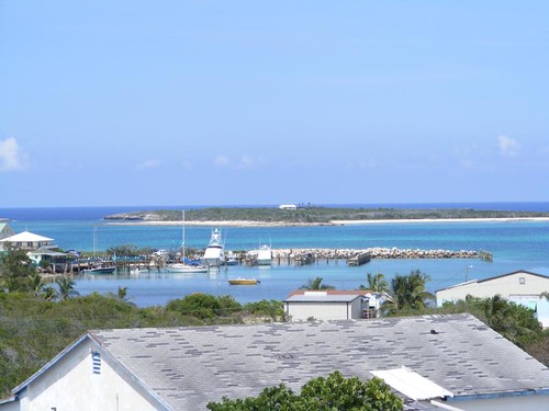
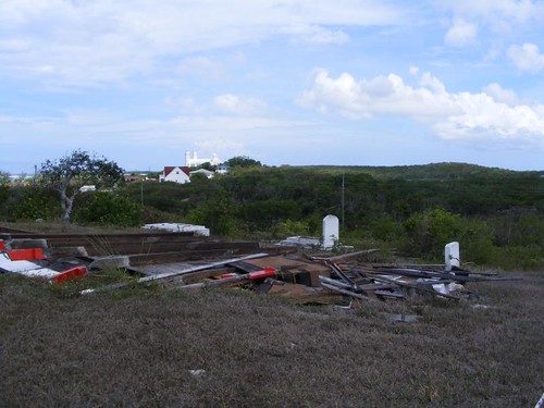
Marina and harbor view
FLUKE is anchored in the top right out of sight in this photo, but you can get a feel for what we are able to see from the boat. Flying Fish Marina is the facility with all the boats, and that's where we were going to walk next.
Flying Fish Marina appeared to be quite busy during our stay in the area. It is the last place you can buy fuel if you are heading south to Crooked Island. Plus, we heard several boats coming into the Bahamas from the Caribbean use it as a place to stop to refuel and clear customs. The small marina is also conveniently located within only a short distance, like 1/4 mile to the deep ocean drop off, so sportfishermen have quick access to their daily fishing activities and then can get reliable, clean fuel since they have to fill up about every time they leave the dock.
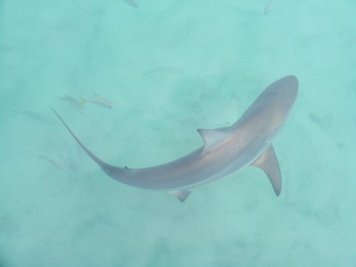
Another marina visitor
Someone had recently used the fish cleaning table at the marina and had thrown the scraps into the water. It looked like feeding time at a tourist aquarium. There were all kinds of fish picking away at the scraps. When two big black tip sharks came warily through, all the other smaller species got out of the way. The sharks didn't just take a small bite, they took whole carcasses, not leaving much for the smaller fish. I never tire of watching the fish activity, if I am on land or in the water.
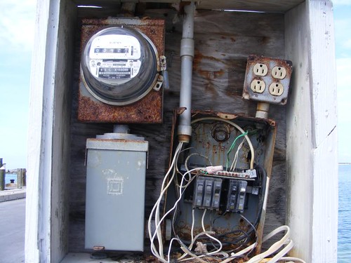
Needs a hazard sign
I thought you might like to see the main, apparently all-weather, electrical panel at the government dock. Notice the fine wiring arrangements.
The government dock was a hubbub of activity the night of the full moon because it was time for the Great Mutton Snapper Hunt, an annual local event throughout all of the islands at this time (last of May/beginning of June) of the full moon. Apparently the mutton snapper, which can get really large with delicious meat, migrate into the shallow coastal areas to mate during the light of this full moon. Many fishermen had brought boats on trailers and launched them to go out that night. It was the most boating activity we had seen since Spanish Wells. When that big magical full moon rose over the eastern horizon I was wishing that I could have gone out on one of the boats to see how they fished for the mutton snapper. After dark, I could see the lighted boats out to sea and was hoping they all came back with a good catch for their efforts.

Lloyd scores first
While we didn't get to fish for mutton snapper, we finally had the opportunity, thanks to the winds diminishing and skies clearing, to go out one morning and try our luck at spearfishing. While, we didn't see many fish that we wanted to spear in the crystal clear water, Eddie nabbed a 3# grouper that provided a delicious lunch feast.
Since it was already June 5, and we want to be back in the Abacos by June 29, we decided not to try to make it over to Crooked Island. It would just force us to rush too much. That decision gave us the opportunity to be adventuresome and head south 10 more miles to a tiny coastal hole appropriately named Little Harbour. What a great move!


Great post as always! Hopefully we will get to see the Flukesters on June 29th!
ReplyDeleteDavid & Kathy
Lady K
Beautiful as always - just how wide are those salt canals?
ReplyDeleteEnjoying the adventure.
Thanks!
Jerry