Safely Exploring With the Dinghy
I'm not going to be able to do a very good job conveying how really bad and scared we felt the two days after we left the Fish Cays, but I'll try to think of some adjectives as I write to give you an idea. The first thing that comes to mind is what I've told you before: Three Sea Stooges.
For those of you who are reading this that aren't cruisers, or just not familiar with the geographical layout of where we have been traveling with FLUKE, I'll give you a general overview of these out islands, so you will understand what we managed to get ourselves into.
Think of all the islands as just little strips of land. On one side (call it the outside) is the deep Atlantic Ocean, and on the inside is the shallow, mostly sandy, Bahama Banks. A treacherous, shallow barrier reef lays between the ocean and the islands. Cuts are trenches (deeper water) that flow through the barrier reef where strong currents bring the ingoing and outgoing tides from the ocean to the Banks. Nautical charts show ways of getting safely from one island to the next, from the ocean to the Banks using the cuts, and around the shallow Banks. Where you can take your boat really depends on how much water your boat needs under it to keep it floating or from hitting anything on the bottom, the worst being a big, hard, sharp coral head. So, the courses on the chart try to avoid those things that would do damage to your boat or get you stuck (like the sailboat W & E helped). Most of the time, we travel either outside the barrier reef, in the deep ocean, or on the Banks in chartered waters where it is deep enough for FLUKE's 5.5 ft. draft.
Since the pending wind changes had forced us to get out of the Fish Cays, Captain Wayne decided that we would go to the Carter Cays, a place we hadn't visited before for several reasons, the biggest one being that in order to get into the anchorage the “normal” way you have to transit a rocky bar on high tide. Then, you have to anchor in a cut between two small cays which have strong currents. Captain Wayne read in one of our cruising guides that there was a “back” entrance into the anchorage. When I looked on the chart I could see what he was talking about, but that entrance was protected by a huge sand bar, the kind I've described before that is only listed as “shifting” on the charts. That means, there's no guarantee that an easy to navigate channel will be there. However, I agreed with Wayne that even if we couldn't find the back entrance channel, we could anchor off the end of the bar and be okay with the predicted winds.
So, we had the destination in mind, but the next hurdle was really getting to that back entrance from our anchorage in the Fish Cays. The only way to do that was to travel in the area between the barrier reef and the cays. There is no charted course, and you have to proceed with caution, using what is called a visual piloting rule (VPR). VPRs frequently appear on charts in areas that are questionable for transiting because there are shifting sands, coral heads, rocks, or other obstructions. A captain of sane mind only transits those areas with good light, moderate winds, and favorable (mostly rising or slack) tides. We knew we would have to be going between and over coral heads, so we wanted to be on a high tide.
When we got up the morning we were going to leave, we decided we had time to go out to the reef one more time before the tide got high enough for us to leave. Fishing was good, and we caught several, but we stayed a bit longer than we should have (it's always the same chant: let's go down one more time!). Eddie said he would clean the fish underway, so we hauled up the anchor and began the journey.
We had good light, but Wayne still had to get up on the pilothouse roof to clearly see the coral heads and tell me where to steer FLUKE, while I watched the depth gauge making sure there was enough water to go where he was telling me to go. The depth alarm went off so frequently, indicating we had less than 2' under the keel, and many times I could see the digital readout indicate less than 1'. Thank goodness winds were mild, so that we weren't getting bounced up and down.
Eddie was in the cockpit cleaning the fish and could look over the side and see the treacherous, yellow coral heads looming up to the surface as we slowly glided by. He thought for sure that we were going to break off one of our stabilizers since they stick out to the sides of the boat, and it looked like to him that we were just easing through coral canyons where there wasn't much more room than the width of the boat. I lost track of how many times I eased FLUKE down to idle just waiting to hear a crunching sound when we hit something. It took us 3.75 hours to go 15 miles, but it felt like we had been underway for 8 hours.
When we got to the back entrance, light and tide had faded, and there was no way we could try to find the “channel” and get into the anchorage. We felt we had pressed our luck to the max, and didn't want to tap King Neptune's gratitude any more than he had already extended it. So, we decided to drop the hook outside the bar. Space between the coral heads was rather limited for our swing room, but we made do. When Eddie hopped in the water to check the anchor, there was a small coral head right off our stern that had 5 lobsters and a couple of small grouper peering out.
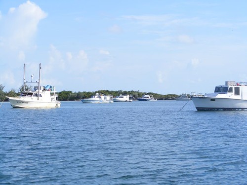
Bahamian Fishing Fleet
There was still enough light left to do some exploring with the dinghy. In particular, we needed to see if we would be able to get into the anchorage the following day when the tide was favorable. Fat chance!
We had heard that in recent years Carters Cays had become the home port for native fishing vessels. No one lives there, but fishermen from nearby cays had taken to using the safety of the anchorage and its close proximity to the offshore reefs and inshore banks as a place to keep their boats. So, we weren't surprised when we saw all the moored boats you can see in the photo. Even if we had taken FLUKE inside there wouldn't have been enough room for us to feel comfortable and secure in the area not occupied by the native boats. They had the best spots for holding and avoiding the worst of the currents.
One boat was being tended to by a family with several children. They all waved at us as we dinghied by and were laughing and pointing when they saw Ursa straddling one of the pontoon tubes. We continued on through the anchorage to check out the tricky “front” entrance, which was not to our liking either. We had originally thought that if we managed to get in the back door, we would head back to the safety of the Banks using the chartered course out the front door. Nix that idea after our dinghy recon mission!
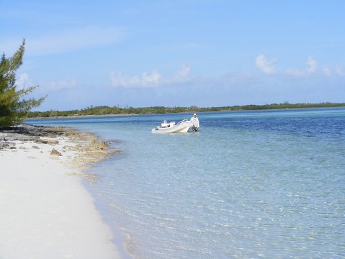
We continued on with the dinghy to check out the other nearby cays. We could see the remnants of an old missile tracking station, one of many (we've seen others in various parts of the Bahamas) left over from the early days of space exploration. The tiny keyhole of Hogstye Harbor contained a sportfish boat (BACKLASH) safely tucked in behind a rocky strip of land with a tiny entrance hole wide enough for the boat to go through only on high tide. We stopped in and said hi to him. Going over to Jacks Cay we found a nice beach to land the dinghy and go for a picturesque walk on the idyllic little cay surrounded by calm, colorful, shallow waters. I just kept wanting to walk around the next point, losing track of how far I was from the dinghy. I was happy to see Wayne come around the point behind me walking with the dinghy, and that's the photo at the beginning of the post. Native blooms provided fragrant, aromatherapathic scents helping drain away the tension of the day. The footprints (and paw prints!) we left behind were the only ones on this remote little beach.
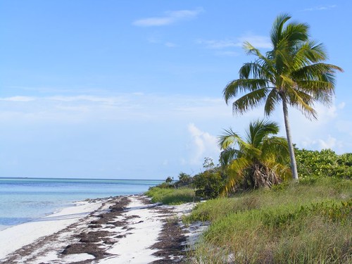
Secret Beach
After surveying the entire area and getting an updated weather forecast anticipating higher winds, we knew we had to leave the following day and seek a safer anchorage. We had a feeling of being “trapped” in that we would never be able to move FLUKE at all during the night if a storm blew in and caused our anchor to start dragging. Plus, we would need good daylight to weave our way through the coral heads again to get us out of the area to deep water, and if it was too cloudy we would be stuck there until we could safely get underway.
Fortunately, the new morning came with some decent light and a rising tide, so we decided to get going while the going was good. BACKLASH was easing himself out of Hogstye Harbor, and we called him on the radio for advice about getting out of the area. He offered some helpful suggestions, saying the trip will have a lot of “pucker” factor to it, but if we kept our eyes open and picked our way through the heads, we would have enough water to get us to a navigable channel that would take us over to the safety of the Banks.
We were working with more water than we had the previous day, and the coral head formations were much larger, rather than small and numerous, and had enough space between them for us to weave through the 10 miles we needed to go. We would have thought it was a difficult transit if we hadn't been so “challenged” the previous day. So, as it was, we had a less stressful voyage and breathed a big sigh of relief to get back to more familiar, safer waters.
We dropped the hook at Great Sale Cay on the northwest side. Great Sale is a frequent stopping anchorage for boats coming over from Florida where cruisers can rest for a day before moving on into the rest of the Bahamas. The flat, mostly mangrove, cay is uninhabited and doesn't have any outstanding land or water attractions to keep people anchored for any length of time. However, because of its shape (like a giant wishbone) it affords protection from windy weather in many directions with good holding and room for lots of boats.
There are a few areas of sandy beach, depending on what side you anchor. We explored the shoreline, which I nicknamed Pig Poop Beach because it was loaded with the most pig poop I have ever seen outside of attending a state fair. Native Bahamians drop hogs off on uninhabited cays to “get fat” until they are ready to be eaten. They are free to roam, root, and ravage the native wildlife, flora and fauna, without anyone having to worry about caring for them or cleaning up after them. We reported they did the same thing with goats and sheep when we were in the Jumentos.


And I thought you guys were always just kicking back, relaxing, and enjoying things.... but was it as stressful as work?
ReplyDeleteThe water there is just amazing. I'm so used to the east coast beaches.
Al
Wow...actually sounds a little stressful:). Great 'postcard' type pictures. Thanks as always for sharing your adventures.
ReplyDeleteBob and Dorinda