Part 3: Morton Bay
Peeking in at Morton Bay
The cruising guide's description of Morton Bay sounded just like the kind of place we try to seek out: beautiful, well-sheltered, scenic, with loons and ospreys. It is not too far off the main cruising route of the usual Rideau traffic path, so it is well worth the time to take to spend at least one night at anchor. There is really not another place like it on the Rideau.
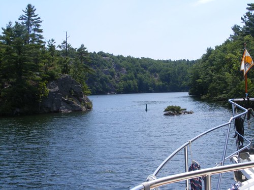
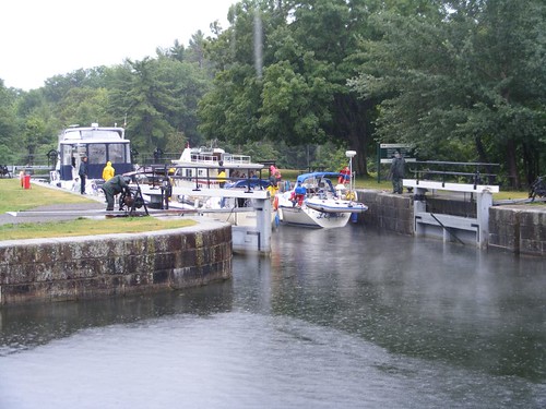
From the opening photo you can see that the entrance is very narrow, only about 30' wide. However, the water is deep to get in, and you just pass between that straight down-to-the-water cliff on the left side of the photo and keep the green channel marker next to that clump of rocks sticking out of the water on your starboard side. As soon as you get through the entrance your jaw will drop and you will be so surprised to see that you are in a big basin with high cliffs all around you.
Our destination: the highest peak
The bottom of the long bay is muddy and very weedy with thick, rotten gigantic mats of decayed vegetation. We switched back to our Delta anchor and got good holding. As long as you aren't close to anyone else or the rocky shoreline you should have plenty of time to react if your anchor drags anyway.
As soon as the anchor was set and we could look around, we spotted people at the highest point on top of the boulders visible in the photo above. We knew we had to figure out how to hike up there!
The next morning we launched the dinghy to take to the opposite end of the bay (20 minute ride), where the cruising guide said was a dock. We figured that there might be some information there that could tell us where the trail head was to Rock Dunder, the boulder peak.
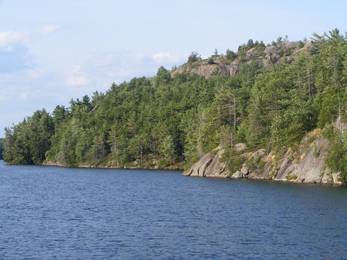
The half mile ride through the bay was very picturesque since the sides are steep with lots of overhanging boulders and trees. One big boulder had a huge flat surface and extended out quite a ways from shore. Plus, there was a long rope attached to a nearby tree. It must have been a really neat jumping rock for the locals.
We were disappointed to arrive at the dock and not find any signage except no trespassing signs for the private property near the dock. Since there was a road going down to the dock we decided to walk uphill and see where the road went.
The road exited into the little, dead village of Morton, right next to a yard where there was a garage sale. Eddie and I love to go saling, as we call it. Plus, the woman was selling home-baked cookies in addition to all kinds of typical garage sale stuff we don't really need, but had to look at anyway. In addition to the cookies, we even found some things that we wanted, but we didn't have any money on us. We told her that we would go back to FLUKE and get some money after we hiked up to Rock Dunder, if we could find out how to get there. She had no clue about Rock Dunder, but she called her husband to come outside. While, he wasn't sure exactly how to get there, he remembered that the Boy Scouts used to have cabins in the area, and he knew the road that they took to get to the cabins. Even if we couldn't find the road at that point, we had had a great time talking to those two friendly locals.
The entry road was about ¾ mile from the garage sale, and then we had another 1/4 mile until we came to a parking area with the Rock Dunder signboard map. We learned that the Rock Dunder property consisted of 276 acres and was managed by a conservation group called the Rideau Waterway Land Trust. RWLT had purchased the land from Scouts Canada in 2006 to provide recreational opportunities for nature enthusiasts like the FLUKE crew.
There are several well-marked trails through the property that wind through a variety of habitats, from boggy areas with beaver ponds, up through mixed hardwoods and pines, all the way up to the lichen-covered boulders. We decided we would hike a 2.5 mile loop that would give us a chance to see a lot of the property.
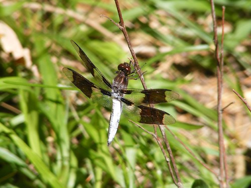
Dragonfly
One of the wetland meadow areas had lots of these pretty dragonflies. Mosquitoes weren't really a problem anywhere along the trail. However, the deerflies were very pesty, especially going after Ursa's ears, always trying to burrow down through her thick hair. Once we got to the open areas along the top of the ridge they weren't bad.
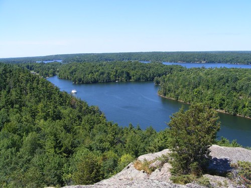
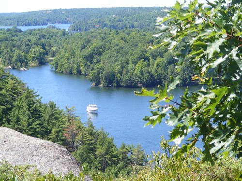
We could see everything!
When we finally arrived at the highest ridge, 550', and looked out into the distance, we knew all the effort to find the place had been worth it. We could see well beyond the bay to the waterway we had taken from the last lock and that which we would take after we left the bay. FLUKE was visible way down below, as you can see in the left part of the picture above.
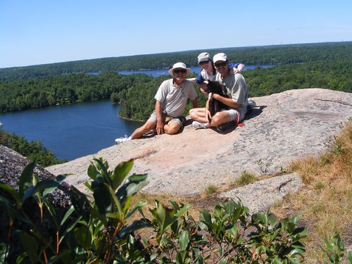
FLUKE crew conquers Rock Dunder
We all managed to gather together for our group photo. It is amazing how happy we look. Right before the photo we were all yelling at each other about where to put the camera, how to get the auto setting to work right, and who was going to be where in the photo. Since I was the one having to push the button and run back to the group I got yelled at the most; it took me 3 tries to get it right!
FLUKE from another level
Eddie scampered around on some other nearby boulders, and Wayne and I found some wild blueberries to snack on. It was well past our regular feeding time, so we had to get back. Thoughts of those cookies at the garage sale were foremost on our minds.
The garage sale was still going on when we passed through on the way back to the dock. Eddie said he would meet the guy at the dock and give him the money in 40 minutes, 20 for us to get back to FLUKE to get the money and then another 20 for Eddie to have to dinghy back to the dock to make the payoff.
Earlier in this post, I mentioned loons. They are the official bird of Ontario, and if you ever see one you will know why. At this time of year the males have their full breeding plumage, striking black and white stripes and dots. These big birds are 2-3' long and have wingspans of 4-5'. However, they are very cautious and do not come around to beg for food or let boats get very near them. I am going crazy trying to get a good photograph of a loon that really shows the beautiful plumage, but I am not having much success. Before this trip ends, I will show you my best effort, but don't place any bets that I'm going to come up with something great as far as these elusive birds go. Another thing, they have the strangest call of any bird I have ever heard, especially at night; it sounds like a cackling howl. Trying to get a good photo is going to drive me into becoming a real loon-a-tic before it's over!
All weather cruisers
“In every silver cloud there is a dark lining” isn't really how that old familiar saying is supposed to go, but it describes how the skies changed from one day to the next. Those beautiful blue skies that shown upon us as we stood on top of Rock Dunder had changed to these gray misty skies early the next morning when it was time to haul up the anchor. As Eddie was looking at the anchor chain coming up out of the water, he said it looked like we were pulling up a 100 year-old Christmas tree since all the ancient organic matter was clinging to the chain, draping back down towards the water.
As we squeezed out the skinny opening to head back into the main cruising stream, we all agreed that secretive Morton Bay should be on any cruiser's “must stop” list.
July 25 – 26, 2011
Part 4: Jones Falls
Overview of Jones Falls
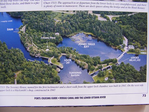
We only had 2 miles to go once we left Morton Bay before we reached Jones Falls. If you look in the photo above, we tied off on the floating dock (the blue line) next to the bridge visible towards the right side of the photo. Since this is a combined lock (3) and a detached lock, and you are required to lock through them all once you begin, we needed to see where we would fit in the time schedule. So, Captain Wayne went up the hill to talk to the lockmaster and explain the need for us to have as much water as possible. We had been instructed to say that every time we went in a lock. Word gets passed by telephone to other locks when boats like FLUKE are coming anyway, so that the lock staff can do whatever they need to do to get ready, especially in regards to holding the lock open and waiting.
Notice the lock numbers are decreasing for the direction in which we are traveling; the combined chambers are locks 42, 41, 40 and the detached lock is 39. Even though the turning basin appears to be very large, protected, and have nice walls all around, it is very shallow and boats are not permitted to stop. The basin is a popular swimming area for travelers and locals who come to use the facility.
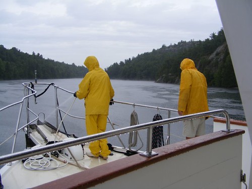
Locking through rain or shine
Since it appeared that it was going to rain all day anyway, we told the lockmaster we would lock through on the first available opening he had, which turned out to be the first lock up of the day. We just put on our rain gear and did the job. Because it was so early, we were lucky to find dock space just above Lock 39, to the right, below the Sweeney House. It was a great location to be able to watch other boats locking through like in the above photo.
All of the locks are land parks too. They have picnic tables, grills, and places to fish. A lot of them have historical buildings (with interpretive displays or artifacts), swimming areas, or hiking trails. Many people canoe the Rideau and set up camp right on the lock property. Day people come to the locks just to watch all the activity going on. Jones Falls is one of the most popular day use parks because it has all of the above, plus you can buy ice cream at the Hotel Kenney snack bar. In the aerial photo it is located on the right hand side, just above the floating dock we tied off to before we went into the first flight lock.
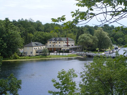
Hotel Kenney
The Hotel Kenney was built in the 1880s as part of the building “boom” associated with the tourists coming to the Rideau Canal. It was built as a fishing lodge. If you go in the main lobby and just sit in front of the fireplace you can imagine that you are in the late 1800s.
A good place to start a visit at Jones Falls is to stop at the Visitor Center located on the east side of the flight locks. You can't see the building in the aerial photo because of all the trees. The building has served for storage since the turn of the century, but now also has restrooms and the orientation center where you can pick up written literature and watch some interesting audio/video presentations about different parts of the Rideau Canal. There is also a stone-cutting demo that lets you see how the big key-shaped blocks are cut so that they all fit in correctly to hold themselves in the walls.
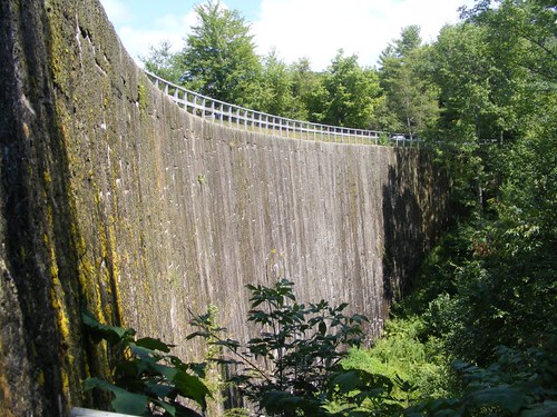
Stone arch dam
It was necessary to build a dam so that water for the locks could be controlled. It had to be 60' in height, making it the biggest dam of its time built on the North American continent. Each block was 6' x 3' x 2' in size. The huge blocks were moved from their quarry site 6 miles away in winter since the frozen ground made it easier for the oxen teams to pull them. The final dam was 217' wide at the top and 100' wide at the base and still looks as good as it did 175 years ago.
The original plan called for water to flow over the dam as needed for high water levels, but erosion at the base of the dam was feared so a waste weir was constructed. It is now a small trickle down waterfall, all that remains in the name of the original Jones Falls.
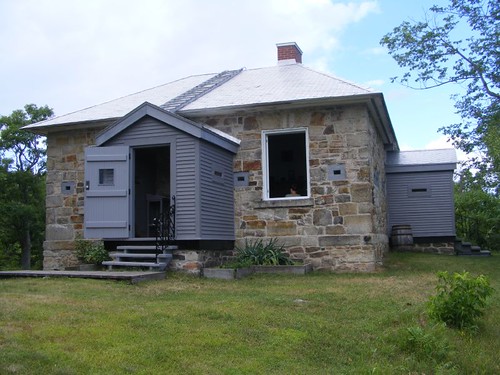
The Sweeney House
A big boulder's throw from the little falls, and just above where we were docked, is the 1841 Sweeney House, visible in the photo above. It is one of the defensible lockmaster's houses built as a cheaper alternative to the blockhouses Colonel By had hope to build for each lock. The beautiful stone walls are very thick, and you can see the gun slit holes all around the structure. The casement windows, rare at the time, were used because they swung inward and could be fitted with fireboards during an attack.
The Sweeney House is set up as an interpretive museum. The house is furnished much like it would have been when John Sweeney and his family lived in it. It is open free to the public and a person in period costume is available to answer questions. When I went in, a girl was spinning yarn from raw wool. She pointed out that John Sweeney's diary was found in the house and a copy was available for reading excerpts. He wrote about the isolated, difficult life he had with his wife and daughter. He was particularly frustrated with the two women drinking and he tried to take away their liquor bottles, but they kept hiding them out in the woods where he couldn't find them. At one point he paid his wife to leave him, but the locals sent out a search party and brought her back because payoffs like that were illegal. Times sure have changed!
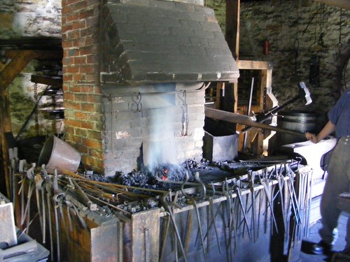
Blacksmith shop, 1843
Working in another defensible building, the blacksmith played a critical role in helping to repair and maintain canal structures. Being in such an isolated area, workers would have had to wait weeks for repair parts if they hadn't had their own blacksmith on site. Today, the forge is fired up, and you can watch metal hardware items being created by a blacksmith. He makes nails to give out free to children, and sells decorative tools and hardware as well as some artistic metalwork pieces.
Packing them in
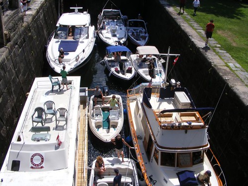
If you want to see some real lock action after you check out the historical buildings, there will be plenty to see, especially on the weekends. The lock staff does a wonderful job trying to move as many boats as possible into the locks. It is surprising how much cooperation even exists amongst the boaters themselves, squeezing their boats in place and getting their fenders and lines in order without tempers flaring.
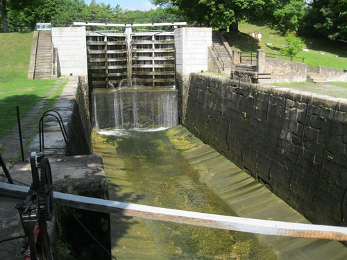
Repair time
Boaters get a bit frustrated when they hear that the locks are shut down temporarily for repairs. Not only can't boats enter the lock, the space also gets very congested at the blue line, and boats have to end up rafting up or turn away altogether, and that can be difficult when the waterway approaching the lock is very narrow. During our stay, the Jones Falls locks were shut down a couple of hours during midday one day. The lock chamber had to be drained so the maintenance man could do the repair work. This photo shows the drained chamber. Note the sill visible towards the end of the chamber. For FLUKE to clear the sill, there needs to be just over 5' of water above it. If you look closely on the sides, you can see the water stains which hardly look like they are much more than 5' up the sides of the wall.
There are several hiking paths around the facility, some of which give you the opportunity to see what the terrain was really like when the lock was being built. After we had hiked all the trails, visited all the displays, and waited for good weather to return, it was time to leave the dock again and creep slowly onto to the next lock.


Thanks. It is beautiful.
ReplyDeleteExcellent group shot - it was worth all of the yelling :-)
ReplyDeleteThanks,
Jerry