Part 7: The Narrows

Overview of the Narrows Lock
Looking at the above photo, you can see why they call this lock The Narrows. Before the canal construction days, Big Rideau Lake and Upper Rideau Lake were all one lake. Colonel By figured out it would be easier to build a dam and a lock at this narrow portion of the lake which would raise the level of the Upper Rideau side about 5', allowing for less digging through bedrock to make a navigable channel on the Upper Rideau side.

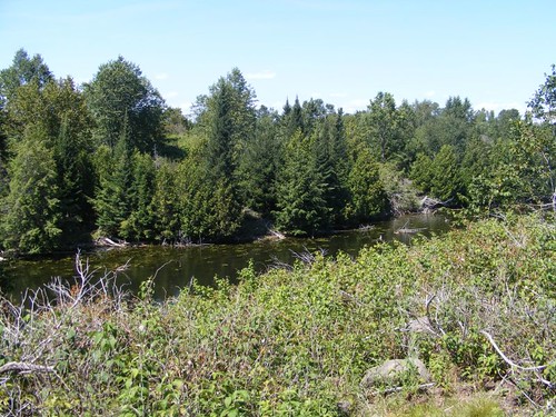
A pinhole channel in the lake
You can see from this photo how narrow the channel really is even though it is surrounded by a broad expanse of lake water. We had to pay close attention to markers like this, so that we could be “guaranteed” to find the deepest water for our passages. Remember, I told you that Colonel By wanted to minimize having to dig through bedrock, and we sure didn't want to end up on any of it he didn't dig out, outside the channel.
We had only traveled 5 miles from Newboro before tying up to the dock in the right hand side of the photo, on the side where you can see the two boats. It was pretty windy, so we wanted to wait for another day before we locked through here. It would be the first time we would enter a full chamber to begin locking down, and we had heard that the water level would be almost up to the top of the lock. That could mean that if it was windy we could get pushed too close to the side of the lock and scrape the hull. We were also worried that the lock attendants would be in added danger of trying to push FLUKE from the sides.
All that silvery looking stuff in the upper right of the photo isn't ice; it is a big mat of algae and aquatic plants I spoke about earlier. That area is very shallow.
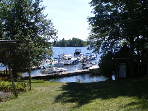
Notice how really long the docks are for this lock. That is because this lock gets so much day use by locals making ice cream runs to the nearby town of Westport. (We couldn't visit that town because there isn't enough water in the area for us to get into the town dock.) The blue lines fill up quickly with boats waiting to lock through, and the little lock runs continuously on nice days during the season.
Local land lubbers come to the lock just to watch all the boats locking through. A lot of people are there to look at not only the boats, but also the people, mostly women, on the boats. Through not so astute observations, I have learned that in these waters, a critical part of every woman's boating wardrobe is what she will be wearing to handle the docking lines for going through locks. This can vary from small pieces of fabric covering critical parts so as not to be arrested, but still leave little to the imagination, to flowing sarongs, long or short in length (mandatory to be cut as low as possible), and all kinds of outfits in between. There is no age requirement for any specific outfit either. It is not easy to move around on some of the boats to handle the lines because the bows are very steep and the railings low and flimsy. That forces the line handler to slide around on her butt, many looking like sea lions trying to move on land. No matter what the outfit is at that point, there is no element of grace involved. Call up Eddie to hear him describe what that maneuver looks like if a woman isn't wearing any underwear! No photos will be shown of me in my line handling outfit because I never did get one. As usual, I'm just not with “it” as far as fashion goes.
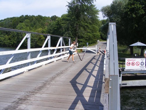
The Narrows swing bridge
This little bridge operates in conjunction with the lock. It is cranked opened and closed by hand as demonstrated by the lock attendant walking the crank around a gear set in the bridge. To our complete surprise, spectators are even allowed to be on the bridge when it is moving. You can also see one of the little traffic gates which are manually opened and closed. On Sundays, the entire lock is operated by an all-women crew.
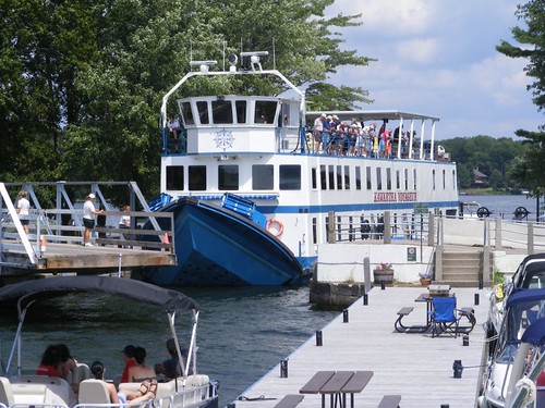
Kawartha Voyageur
Imagine our surprise when we looked out to see this canal cruiser in the lock. It was constructed specifically to fit through the locks by having a fold-up bow. In the photo, the bow is in mid-position, waiting to get fully lowered. We ran into the Kawartha another time later on and had the opportunity to talk to some crew and passengers. It makes a 5-day cruise from Ottawa to Kingston; we spent 3 weeks. The draft is only 4', but that is across the whole bottom, so they, too, are challenged in some of the shallower areas, especially where the weeds are really bad. One of the passengers told me they served food 8 times/day and it was all homemade and really tasty. Most passengers gain 10 lbs. on the trip!
Eddie made his first French-speaking friends here, Francoise and Louise. Because Francoise spoke such good English, Eddie was able to communicate well with him, engaging in boating and political conversations over a couple of beers. We would end up seeing them again a couple of more times before we left Canada, and it was always nice to see their familiar faces in the crowds of French-speaking people in which we would find ourselves.
August 1, 2011
Part 8 - Colonel By Island
We can't believe it is already the beginning of August. We must be enjoying ourselves since we have lost track of time. We even think we are going to be able to make it all the way through the Rideau without having to turn around and go back.
After we left the dock at the Narrows, and locked through and down without incident, we entered Big Rideau Lake. It is named that for a reason since it is the largest body of water on the Rideau system, and one of the prettiest. I always talk about how shallow the water has been for us. Well, on BRL, we passed over one spot that had water 330' deep – can't complain about that! There are beautiful vistas all around because of the interesting rock formations, some with significant elevation changes. It is said that there are so many places to anchor here, a cruiser could spend the whole summer exploring, and living off the waters since the fishing is supposed to be excellent, and there are sources for ice cream nearby.
Our destination was Colonel By Island, currently under the ownership of Parks Canada. However, the island was originally a summer cow pasture, called the Isle of Guernsey, until the late 1890s when it was sold to be used for a fishing lodge location. After a few other changes of ownership Parks Canada purchased it in the 1980s with the idea of honoring the canal's builder. After exploring the island, I think Parks Canada could have picked a better island, more representative of the beauty of the canal, complete with more of the geological and natural challenges that Colonel By had to overcome during construction.
The crowded dock
We originally intended to tie up at the park dock. However, when we pulled up there were 3 boats at the dock, all with large spaces between them. If any one of the boats could have moved closer to one of the others, we could have found space. By the time we had our anchor set, we could see 3 other boats headed toward the dock. When they got to the dock, the other boats moved. Clearly, they were saving the space for their friends. They could get away with doing that there because no park personnel are present to direct dockage like what happens at the lock docks. Oh well, we had a nice view from where we were anchored and didn't have to listen to all the noise from the dock party that developed.
We did launch the dinghy to go ashore to explore the island. A placard said that there was a 2 mile hiking trail loop around the island so we decided to take that.
Scenic overlook
Overall, the island is mostly flat, so the trail is easy. We did find one nice overlook, with the big rock formations that are present around the lake. Since it was originally used as a cow pasture a lot of the native vegetation had been cleared for the pasture field so there are no old stands of conifers or hardwoods.
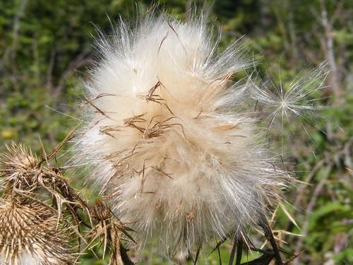
Thistles
One dry area had some thistles that had already gone to seed and were flying in the wind. I always like to see those delicately dancing through the air. They were next to a berry patch where I could pick a few for a snack.
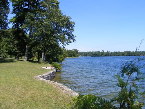
The picnic area
The public area off the dock has a nice picnic area and neatly mowed grounds. The pretty, curved, stone wall breakwater is a great place to catch some rays after you get out of the cold, clean water. Just beyond that is a great swimming area which has a natural, flat rock bottom so you don't have to worry about swimming in so many aquatic weeds.
The best part about visiting Colonel By Island is not going ashore, but just enjoying the beautiful scenery in the vicinity; it reminded me of some of the islands in the Thousand Islands. Plus, I saw several loons and tried to take some more pictures to add to my growing collection of lousy possibilities to share with you. I haven't given up, but my optimism is waning.


I've run out of adjectives! Breathtaking vistas, fish & ice cream - close to nirvana I think. Fluke looks very proud of herself at the Davis dock - very regal. Hope the trip south continues to amaze you! I'm amazed that Eddie didn't talk the canal paddler into letting him take a test run. Happy birthday to Ursa!
ReplyDeleteTechnically you've already delivered on the loon picture :-)
ReplyDeleteThanks for bringing us along!
Jerry